Saint-Loubès geodata
Saint-Loubès (Nouvelle-Aquitaine) is a populated place; located in France in Europe/Paris (GMT+2) time zone. With population of 7,678 people, there are 1261 cities with bigger population in this country. Compared to other cities in France, 80.4% of cities are located further ↑North; 82.5% of cities are located further →East and 92% of cities have higher elevation than Saint-Loubès. Note1
Administrative division(s):
- Level 1: Nouvelle-Aquitaine
- Level 2: Gironde
- Level 3: Arrondissement de Bordeaux
- Level 4: Saint-Loubès


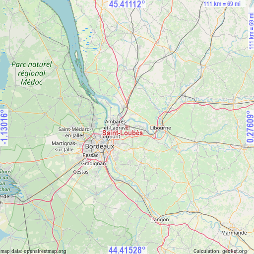
Saint-Loubès GPS coordinates[2]
44° 54' 55.296" North, 0° 25' 37.308" West
| Map corner | latitude | longitude |
|---|---|---|
| Upper-left | 45.41112°, | -1.13016° |
| Center: | 44.91536°, | -0.42703° |
| Lower-right: | 44.41528°, | 0.27609° |
| Map W x H: | 110.7×110.7 km | = 68.8×68.8mi |
| max Lat: | 51.07786° ⇑80.4% North |
| Saint-Loubès: | 44.91536° |
| min Lat: | ⇓19.6% South 41.3874° |
| min Long | Saint-Loubès | max Long |
| -5.08615° | -0.42703° | 9.52242° |
| W 17.5%⇐ | ⇒82.5% E |
Elevation
Elevation of Saint-Loubès is 25 m = 82 ft, and this is 168.7 m = 553 ft below average elevation for this country.
| Max E: |
2333 m = 7654 ft | 92% |
| Avg. | 193.7 m = 635 ft | |
| Saint-Loubès | 25 m = 82 ft | |
Min E: |
-1 m = -3 ft | 8% |
See also: France elevation on elevation.city.
Geographical zone
Saint-Loubès is located in North temperate zone (between Tropic of Cancer and the Arctic Circle). Distance of this Northern Tropic circle is 2388.2 km =1484 mi to South.| Distance of | km | miles | from Saint-Loubès |
|---|---|---|---|
| North Pole | 5012.9 | 3114.9 | to North |
| Arctic Circle | 2407.1 | 1495.7 | to North |
| Tropic Cancer | 2388.2 | 1484 | to South |
| Equator | 4994.1 | 3103.2 | to South |


Nearby cities:
15 places around Saint-Loubès: (largest is in red/bold)
• Ambarès-et-Lagrave
4.4 km =2.7 mi,  271°
271°
• Asques
4.3 km =2.7 mi,  17°
17°
• Bassens
7.2 km =4.5 mi,  258°
258°
• Beychac-et-Caillau
4.6 km =2.9 mi,  154°
154°
• Cadillac-en-Fronsadais
7.2 km =4.5 mi,  36°
36°
• Carbon-Blanc
6.2 km =3.9 mi,  250°
250°
• Cubzac-les-Ponts
6.5 km =4 mi,  343°
343°
• Izon
5.1 km =3.2 mi,  78°
78°
• Montussan
3.9 km =2.4 mi,  173°
173°
• Pompignac
7.2 km =4.5 mi,  186°
186°
• Saint-Romain-la-Virvée
6 km =3.7 mi, 21°
• Saint-Sulpice-et-Cameyrac
2.9 km =1.8 mi,  98°
98°
• Saint-Vincent-de-Paul
5.4 km =3.4 mi,  323°
323°
• Sainte-Eulalie
3.8 km =2.4 mi, 255°
• Yvrac
4.9 km =3 mi,  210°
210°
Sources, notices
• [Note1] Compared only with cities in France existing in our database
• [Src1] Map data: © OpenStreetMap contributors (CC-BY-SA)
• [Src2] Other city data from geonames.org with taken over terms of usage.
• [Src3] Geographical zone / Annual Mean Temperature by Robert A. Rohde @ Wikipedia
