Beychac-et-Caillau geodata
Beychac-et-Caillau (Nouvelle-Aquitaine) is a populated place; located in France in Europe/Paris (GMT+2) time zone. With population of 1,926 people, there are 4976 cities with bigger population in this country. Compared to other cities in France, 80.6% of cities are located further ↑North; 82.1% of cities are located further →East and 81.1% of cities have higher elevation than Beychac-et-Caillau. Note1
Administrative division(s):
- Level 1: Nouvelle-Aquitaine
- Level 2: Gironde
- Level 3: Arrondissement de Bordeaux
- Level 4: Beychac-et-Caillau


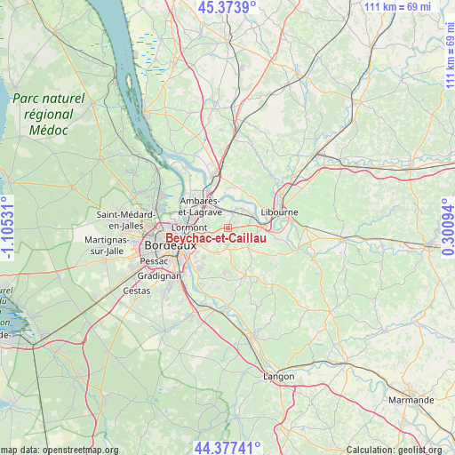
Beychac-et-Caillau GPS coordinates[2]
44° 52' 40.116" North, 0° 24' 7.884" West
| Map corner | latitude | longitude |
|---|---|---|
| Upper-left | 45.3739°, | -1.10531° |
| Center: | 44.87781°, | -0.40219° |
| Lower-right: | 44.37741°, | 0.30094° |
| Map W x H: | 110.8×110.8 km | = 68.8×68.8mi |
| max Lat: | 51.07786° ⇑80.6% North |
| Beychac-et-Caillau: | 44.87781° |
| min Lat: | ⇓19.4% South 41.3874° |
| min Long | Beychac-et-Cail | max Long |
| -5.08615° | -0.40219° | 9.52242° |
| W 17.9%⇐ | ⇒82.1% E |
Elevation
Elevation of Beychac-et-Caillau is 52 m = 171 ft, and this is 141.7 m = 465 ft below average elevation for this country.
| Max E: |
2333 m = 7654 ft | 81.1% |
| Avg. | 193.7 m = 635 ft | |
| Beychac-et-Caillau | 52 m = 171 ft | |
Min E: |
-1 m = -3 ft | 18.9% |
See also: France elevation on elevation.city.
Geographical zone
Beychac-et-Caillau is located in North temperate zone (between Tropic of Cancer and the Arctic Circle). Distance of this Northern Tropic circle is 2384 km =1481.3 mi to South.| Distance of | km | miles | from Beychac-et-Caillau |
|---|---|---|---|
| North Pole | 5017.1 | 3117.5 | to North |
| Arctic Circle | 2411.2 | 1498.2 | to North |
| Tropic Cancer | 2384 | 1481.3 | to South |
| Equator | 4989.9 | 3100.6 | to South |


Nearby cities:
15 places around Beychac-et-Caillau: (largest is in red/bold)
• Bonnetan
7 km =4.3 mi,  188°
188°
• Camarsac
6 km =3.7 mi,  149°
149°
• Fargues-Saint-Hilaire
7 km =4.3 mi,  209°
209°
• Izon
6 km =3.7 mi,  30°
30°
• Loupes
7.7 km =4.8 mi,  171°
171°
• Montussan
1.6 km =1 mi,  281°
281°
• Pompignac
4 km =2.5 mi,  222°
222°
• Saint-Germain-du-Puch
7.4 km =4.6 mi,  114°
114°
• Saint-Loubès
4.6 km =2.9 mi,  334°
334°
• Saint-Sulpice-et-Cameyrac
3.8 km =2.4 mi,  13°
13°
• Sainte-Eulalie
6.5 km =4 mi,  299°
299°
• Sallebœuf
4.9 km =3 mi,  178°
178°
• Tresses
5.8 km =3.6 mi,  235°
235°
• Vayres
7.2 km =4.5 mi,  69°
69°
• Yvrac
4.5 km =2.8 mi,  270°
270°
Sources, notices
• [Note1] Compared only with cities in France existing in our database
• [Src1] Map data: © OpenStreetMap contributors (CC-BY-SA)
• [Src2] Other city data from geonames.org with taken over terms of usage.
• [Src3] Geographical zone / Annual Mean Temperature by Robert A. Rohde @ Wikipedia
