Izon geodata
Izon (Nouvelle-Aquitaine) is a populated place; located in France in Europe/Paris (GMT+2) time zone. With population of 4,317 people, there are 2285 cities with bigger population in this country. Compared to other cities in France, 80.3% of cities are located further ↑North; 81.6% of cities are located further →East and 99% of cities have higher elevation than Izon. Note1
Administrative division(s):
- Level 1: Nouvelle-Aquitaine
- Level 2: Gironde
- Level 3: Arrondissement de Libourne
- Level 4: Izon


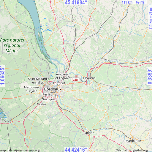
Izon GPS coordinates[2]
44° 55' 26.976" North, 0° 21' 47.592" West
| Map corner | latitude | longitude |
|---|---|---|
| Upper-left | 45.41984°, | -1.06635° |
| Center: | 44.92416°, | -0.36322° |
| Lower-right: | 44.42416°, | 0.3399° |
| Map W x H: | 110.7×110.7 km | = 68.8×68.8mi |
| max Lat: | 51.07786° ⇑80.3% North |
| Izon: | 44.92416° |
| min Lat: | ⇓19.7% South 41.3874° |
| min Long | Izon | max Long |
| -5.08615° | -0.36322° | 9.52242° |
| W 18.4%⇐ | ⇒81.6% E |
Elevation
Elevation of Izon is 6 m = 20 ft, and this is 187.7 m = 616 ft below average elevation for this country.
| Max E: |
2333 m = 7654 ft | 99% |
| Avg. | 193.7 m = 635 ft | |
| Izon | 6 m = 20 ft | |
Min E: |
-1 m = -3 ft | 1% |
See also: France elevation on elevation.city.
Geographical zone
Izon is located in North temperate zone (between Tropic of Cancer and the Arctic Circle). Distance of this Northern Tropic circle is 2389.2 km =1484.6 mi to South.| Distance of | km | miles | from Izon |
|---|---|---|---|
| North Pole | 5012 | 3114.3 | to North |
| Arctic Circle | 2406.1 | 1495.1 | to North |
| Tropic Cancer | 2389.2 | 1484.6 | to South |
| Equator | 4995.1 | 3103.8 | to South |


Nearby cities:
15 places around Izon: (largest is in red/bold)
• Arveyres
7.8 km =4.8 mi,  125°
125°
• Asques
4.9 km =3 mi,  309°
309°
• Beychac-et-Caillau
6 km =3.7 mi,  210°
210°
• Cadillac-en-Fronsadais
4.8 km =3 mi,  351°
351°
• Fronsac
7.6 km =4.7 mi,  96°
96°
• La Lande-de-Fronsac
6.4 km =4 mi, 347°
• Lugon-et-l'Île-du-Carnay
4.1 km =2.5 mi,  31°
31°
• Montussan
6.7 km =4.2 mi,  223°
223°
• Saint-Loubès
5.1 km =3.2 mi,  258°
258°
• Saint-Michel-de-Fronsac
3.8 km =2.4 mi,  74°
74°
• Saint-Romain-la-Virvée
5.4 km =3.4 mi,  328°
328°
• Saint-Sulpice-et-Cameyrac
2.6 km =1.6 mi,  236°
236°
• Vayres
4.5 km =2.8 mi, 126°
• Villegouge
6.9 km =4.3 mi,  46°
46°
• Vérac
7 km =4.3 mi,  19°
19°
Sources, notices
• [Note1] Compared only with cities in France existing in our database
• [Src1] Map data: © OpenStreetMap contributors (CC-BY-SA)
• [Src2] Other city data from geonames.org with taken over terms of usage.
• [Src3] Geographical zone / Annual Mean Temperature by Robert A. Rohde @ Wikipedia
