Ambarès-et-Lagrave geodata
Ambarès-et-Lagrave (Nouvelle-Aquitaine) is a populated place; located in France in Europe/Paris (GMT+2) time zone. With population of 12,955 people, there are 735 cities with bigger population in this country. Compared to other cities in France, 80.4% of cities are located further ↑North; 83.2% of cities are located further →East and 96% of cities have higher elevation than Ambarès-et-Lagrave. Note1
Administrative division(s):
- Level 1: Nouvelle-Aquitaine
- Level 2: Gironde
- Level 3: Arrondissement de Bordeaux
- Level 4: Ambarès-et-Lagrave


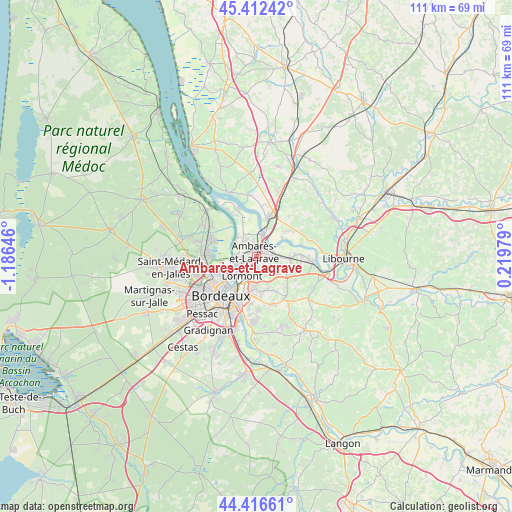
Ambarès-et-Lagrave GPS coordinates[2]
44° 55' 0.012" North, 0° 28' 59.988" West
| Map corner | latitude | longitude |
|---|---|---|
| Upper-left | 45.41242°, | -1.18646° |
| Center: | 44.91667°, | -0.48333° |
| Lower-right: | 44.41661°, | 0.21979° |
| Map W x H: | 110.7×110.7 km | = 68.8×68.8mi |
| max Lat: | 51.07786° ⇑80.4% North |
| Ambarès-et-Lagrave: | 44.91667° |
| min Lat: | ⇓19.6% South 41.3874° |
| min Long | Ambarès-et-Lag | max Long |
| -5.08615° | -0.48333° | 9.52242° |
| W 16.8%⇐ | ⇒83.2% E |
Elevation
Elevation of Ambarès-et-Lagrave is 14 m = 46 ft, and this is 179.7 m = 590 ft below average elevation for this country.
| Max E: |
2333 m = 7654 ft | 96% |
| Avg. | 193.7 m = 635 ft | |
| Ambarès-et-Lagrave | 14 m = 46 ft | |
Min E: |
-1 m = -3 ft | 4% |
See also: France elevation on elevation.city.
Geographical zone
Ambarès-et-Lagrave is located in North temperate zone (between Tropic of Cancer and the Arctic Circle). Distance of this Northern Tropic circle is 2388.3 km =1484 mi to South.| Distance of | km | miles | from Ambarès-et-Lagrave |
|---|---|---|---|
| North Pole | 5012.8 | 3114.8 | to North |
| Arctic Circle | 2406.9 | 1495.6 | to North |
| Tropic Cancer | 2388.3 | 1484 | to South |
| Equator | 4994.3 | 3103.3 | to South |


Nearby cities:
15 places around Ambarès-et-Lagrave: (largest is in red/bold)
• Asques
6.9 km =4.3 mi,  55°
55°
• Bassens
3.1 km =1.9 mi,  238°
238°
• Beychac-et-Caillau
7.7 km =4.8 mi,  124°
124°
• Carbon-Blanc
2.6 km =1.6 mi,  211°
211°
• Cenon
7.3 km =4.5 mi,  202°
202°
• Cubzac-les-Ponts
6.6 km =4.1 mi,  23°
23°
• Lormont
5.4 km =3.4 mi, 210°
• Montussan
6.3 km =3.9 mi,  129°
129°
• Saint-Loubès
4.4 km =2.7 mi,  91°
91°
• Saint-Louis-de-Montferrand
5.5 km =3.4 mi,  312°
312°
• Saint-Sulpice-et-Cameyrac
7.3 km =4.5 mi, 94°
• Saint-Vincent-de-Paul
4.4 km =2.7 mi, 16°
• Sainte-Eulalie
1.3 km =0.8 mi,  147°
147°
• Tresses
7.8 km =4.8 mi,  168°
168°
• Yvrac
4.7 km =2.9 mi,  155°
155°
Sources, notices
• [Note1] Compared only with cities in France existing in our database
• [Src1] Map data: © OpenStreetMap contributors (CC-BY-SA)
• [Src2] Other city data from geonames.org with taken over terms of usage.
• [Src3] Geographical zone / Annual Mean Temperature by Robert A. Rohde @ Wikipedia
