Saint-Laurent-des-Hommes geodata
Saint-Laurent-des-Hommes (Nouvelle-Aquitaine) is a populated place; located in France in Europe/Paris (GMT+2) time zone. With population of 935 people, there are 9342 cities with bigger population in this country. Compared to other cities in France, 79.3% of cities are located further ↑North; 75.8% of cities are located further →East and 83.4% of cities have higher elevation than Saint-Laurent-des-Hommes. Note1
Administrative division(s):
- Level 1: Nouvelle-Aquitaine
- Level 2: Dordogne
- Level 3: Arrondissement de Périgueux
- Level 4: Saint-Laurent-des-Hommes
Current local time in Saint-Laurent-des-Hommes:
04:50 PM, SaturdayDifference from your time zone: hours


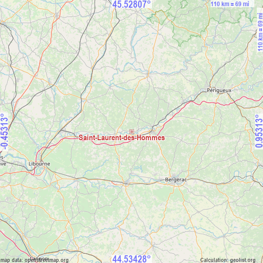
Saint-Laurent-des-Hommes GPS coordinates[2]
45° 1' 59.988" North, 0° 15' 0" East
| Map corner | latitude | longitude |
|---|---|---|
| Upper-left | 45.52807°, | -0.45313° |
| Center: | 45.03333°, | 0.25° |
| Lower-right: | 44.53428°, | 0.95313° |
| Map W x H: | 110.5×110.5 km | = 68.7×68.7mi |
| max Lat: | 51.07786° ⇑79.3% North |
| Saint-Laurent-des-Hommes: | 45.03333° |
| min Lat: | ⇓20.7% South 41.3874° |
| min Long | Saint-Laurent-d | max Long |
| -5.08615° | 0.25° | 9.52242° |
| W 24.2%⇐ | ⇒75.8% E |
Elevation
Elevation of Saint-Laurent-des-Hommes is 46 m = 151 ft, and this is 147.7 m = 485 ft below average elevation for this country.
| Max E: |
2333 m = 7654 ft | 83.4% |
| Avg. | 193.7 m = 635 ft | |
| Saint-Laurent-des-Hommes | 46 m = 151 ft | |
Min E: |
-1 m = -3 ft | 16.6% |
See also: France elevation on elevation.city.
Geographical zone
Saint-Laurent-des-Hommes is located in North temperate zone (between Tropic of Cancer and the Arctic Circle). Distance of this North polar circle is 2393.9 km =1487.5 mi to North.| Distance of | km | miles | from Saint-Laurent-des-Hommes |
|---|---|---|---|
| North Pole | 4999.8 | 3106.7 | to North |
| Arctic Circle | 2393.9 | 1487.5 | to North |
| Tropic Cancer | 2401.3 | 1492.1 | to South |
| Equator | 5007.2 | 3111.3 | to South |


Nearby cities:
15 places around Saint-Laurent-des-Hommes: (largest is in red/bold)
• Douzillac
14.2 km =8.8 mi,  66°
66°
• Le Fleix
18.5 km =11.5 mi,  180°
180°
• Le Pizou
14.5 km =9 mi,  262°
262°
• Montpon-Ménestérol
7.5 km =4.7 mi,  240°
240°
• Moulin-Neuf
14.5 km =9 mi, 262°
• Mussidan
8.9 km =5.5 mi,  88°
88°
• Ménesplet
10.6 km =6.6 mi, 259°
• Porchères
18.3 km =11.4 mi,  270°
270°
• Saint-Front-de-Pradoux
8.1 km =5 mi,  76°
76°
• Saint-Martin-de-Gurson
14.3 km =8.9 mi,  231°
231°
• Saint-Méard-de-Gurçon
15.7 km =9.8 mi,  199°
199°
• Saint-Médard-de-Mussidan
7.9 km =4.9 mi, 90°
• Saint-Vincent-de-Connezac
18.6 km =11.6 mi,  38°
38°
• Sourzac
11.6 km =7.2 mi, 80°
• Villefranche-de-Lonchat
18.3 km =11.4 mi, 239°
Sources, notices
• [Note1] Compared only with cities in France existing in our database
• [Src1] Map data: © OpenStreetMap contributors (CC-BY-SA)
• [Src2] Other city data from geonames.org with taken over terms of usage.
• [Src3] Geographical zone / Annual Mean Temperature by Robert A. Rohde @ Wikipedia
