Saint-Lambert-la-Potherie geodata
Saint-Lambert-la-Potherie (Pays de la Loire) is a populated place; located in France in Europe/Paris (GMT+2) time zone. With population of 2,405 people, there are 4022 cities with bigger population in this country. Compared to other cities in France, 50.9% of cities are located further ↓South; 85.3% of cities are located further →East and 77.8% of cities have higher elevation than Saint-Lambert-la-Potherie. Note1
Administrative division(s):
- Level 1: Pays de la Loire
- Level 2: Département de Maine-et-Loire
- Level 3: Angers
- Level 4: Saint-Lambert-la-Potherie
Current local time in Saint-Lambert-la-Potherie:
02:06 PM, SaturdayDifference from your time zone: hours


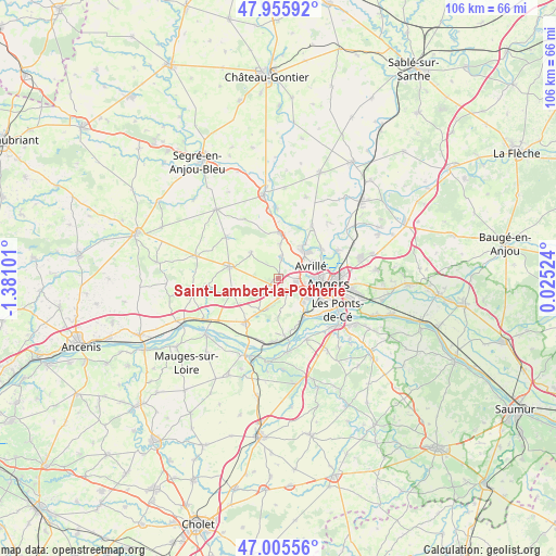
Saint-Lambert-la-Potherie GPS coordinates[2]
47° 28' 58.404" North, 0° 40' 40.404" West
| Map corner | latitude | longitude |
|---|---|---|
| Upper-left | 47.95592°, | -1.38101° |
| Center: | 47.48289°, | -0.67789° |
| Lower-right: | 47.00556°, | 0.02524° |
| Map W x H: | 105.7×105.7 km | = 65.7×65.7mi |
| max Lat: | 51.07786° ⇑49.1% North |
| Saint-Lambert-la-Potherie: | 47.48289° |
| min Lat: | ⇓50.9% South 41.3874° |
| min Long | Saint-Lambert-l | max Long |
| -5.08615° | -0.67789° | 9.52242° |
| W 14.7%⇐ | ⇒85.3% E |
Elevation
Elevation of Saint-Lambert-la-Potherie is 60 m = 197 ft, and this is 133.7 m = 439 ft below average elevation for this country.
| Max E: |
2333 m = 7654 ft | 77.8% |
| Avg. | 193.7 m = 635 ft | |
| Saint-Lambert-la-Potherie | 60 m = 197 ft | |
Min E: |
-1 m = -3 ft | 22.2% |
See also: France elevation on elevation.city.
Geographical zone
Saint-Lambert-la-Potherie is located in North temperate zone (between Tropic of Cancer and the Arctic Circle). Distance of this North polar circle is 2121.6 km =1318.3 mi to North.| Distance of | km | miles | from Saint-Lambert-la-Potherie |
|---|---|---|---|
| North Pole | 4727.5 | 2937.5 | to North |
| Arctic Circle | 2121.6 | 1318.3 | to North |
| Tropic Cancer | 2673.7 | 1661.4 | to South |
| Equator | 5279.6 | 3280.6 | to South |


Nearby cities:
15 places around Saint-Lambert-la-Potherie: (largest is in red/bold)
• Angers
9.8 km =6.1 mi,  95°
95°
• Avrillé
7.4 km =4.6 mi,  75°
75°
• Beaucouzé
3.7 km =2.3 mi, 104°
• Bouchemaine
8.5 km =5.3 mi,  142°
142°
• Bécon-les-Granits
9.4 km =5.8 mi,  282°
282°
• Cantenay-Épinard
10 km =6.2 mi,  54°
54°
• La Meignanne
3.9 km =2.4 mi,  10°
10°
• La Membrolle-sur-Longuenée
8.6 km =5.3 mi,  2°
2°
• Le Plessis-Macé
6.7 km =4.2 mi, 2°
• Pruillé
10.6 km =6.6 mi, 6°
• Saint-Augustin-des-Bois
9.2 km =5.7 mi,  253°
253°
• Saint-Clément-de-la-Place
7.1 km =4.4 mi,  314°
314°
• Saint-Georges-sur-Loire
10.5 km =6.5 mi,  217°
217°
• Saint-Léger-des-Bois
3.3 km =2.1 mi,  226°
226°
• Saint-Martin-du-Fouilloux
5.8 km =3.6 mi,  199°
199°
Sources, notices
• [Note1] Compared only with cities in France existing in our database
• [Src1] Map data: © OpenStreetMap contributors (CC-BY-SA)
• [Src2] Other city data from geonames.org with taken over terms of usage.
• [Src3] Geographical zone / Annual Mean Temperature by Robert A. Rohde @ Wikipedia
