Bouchemaine geodata
Bouchemaine (Pays de la Loire) is a populated place; located in France in Europe/Paris (GMT+2) time zone. With population of 6,534 people, there are 1510 cities with bigger population in this country. Compared to other cities in France, 50.2% of cities are located further ↓South; 84.6% of cities are located further →East and 91.6% of cities have higher elevation than Bouchemaine. Note1
Administrative division(s):
- Level 1: Pays de la Loire
- Level 2: Département de Maine-et-Loire
- Level 3: Angers
- Level 4: Bouchemaine


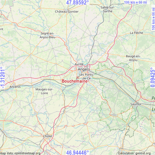
Bouchemaine GPS coordinates[2]
47° 25' 20.424" North, 0° 36' 31.968" West
| Map corner | latitude | longitude |
|---|---|---|
| Upper-left | 47.89592°, | -1.31201° |
| Center: | 47.42234°, | -0.60888° |
| Lower-right: | 46.94446°, | 0.09425° |
| Map W x H: | 105.8×105.8 km | = 65.7×65.7mi |
| max Lat: | 51.07786° ⇑49.8% North |
| Bouchemaine: | 47.42234° |
| min Lat: | ⇓50.2% South 41.3874° |
| min Long | Bouchemaine | max Long |
| -5.08615° | -0.60888° | 9.52242° |
| W 15.4%⇐ | ⇒84.6% E |
Elevation
Elevation of Bouchemaine is 26 m = 85 ft, and this is 167.7 m = 550 ft below average elevation for this country.
| Max E: |
2333 m = 7654 ft | 91.6% |
| Avg. | 193.7 m = 635 ft | |
| Bouchemaine | 26 m = 85 ft | |
Min E: |
-1 m = -3 ft | 8.4% |
See also: France elevation on elevation.city.
Geographical zone
Bouchemaine is located in North temperate zone (between Tropic of Cancer and the Arctic Circle). Distance of this North polar circle is 2128.3 km =1322.5 mi to North.| Distance of | km | miles | from Bouchemaine |
|---|---|---|---|
| North Pole | 4734.2 | 2941.7 | to North |
| Arctic Circle | 2128.3 | 1322.5 | to North |
| Tropic Cancer | 2667 | 1657.2 | to South |
| Equator | 5272.9 | 3276.4 | to South |


Nearby cities:
15 places around Bouchemaine: (largest is in red/bold)
• Angers
7.3 km =4.5 mi,  38°
38°
• Avrillé
8.8 km =5.5 mi,  12°
12°
• Beaucouzé
6 km =3.7 mi,  344°
344°
• Denée
4.8 km =3 mi,  179°
179°
• La Possonnière
7.8 km =4.8 mi,  227°
227°
• Les Ponts-de-Cé
6.3 km =3.9 mi,  89°
89°
• Mozé-sur-Louet
8.2 km =5.1 mi,  149°
149°
• Mûrs-Erigné
5.1 km =3.2 mi,  119°
119°
• Rochefort-sur-Loire
8.1 km =5 mi,  206°
206°
• Saint-Lambert-la-Potherie
8.5 km =5.3 mi,  322°
322°
• Saint-Léger-des-Bois
8.8 km =5.5 mi,  300°
300°
• Saint-Martin-du-Fouilloux
7.2 km =4.5 mi,  279°
279°
• Sainte-Gemmes-sur-Loire
3.9 km =2.4 mi, 89°
• Savennières
5.7 km =3.5 mi,  219°
219°
• Soulaines-sur-Aubance
9.2 km =5.7 mi,  135°
135°
Sources, notices
• [Note1] Compared only with cities in France existing in our database
• [Src1] Map data: © OpenStreetMap contributors (CC-BY-SA)
• [Src2] Other city data from geonames.org with taken over terms of usage.
• [Src3] Geographical zone / Annual Mean Temperature by Robert A. Rohde @ Wikipedia
