Saint-Josse geodata
Saint-Josse (Hauts-de-France) is a populated place; located in France in Europe/Paris (GMT+2) time zone. With population of 1,088 people, there are 8211 cities with bigger population in this country. Compared to other cities in France, 97% of cities are located further ↓South; 60.9% of cities are located further →East and 87.1% of cities have higher elevation than Saint-Josse. Note1
Administrative division(s):
- Level 1: Hauts-de-France
- Level 2: Pas-de-Calais
- Level 3: Arrondissement de Montreuil
- Level 4: Saint-Josse


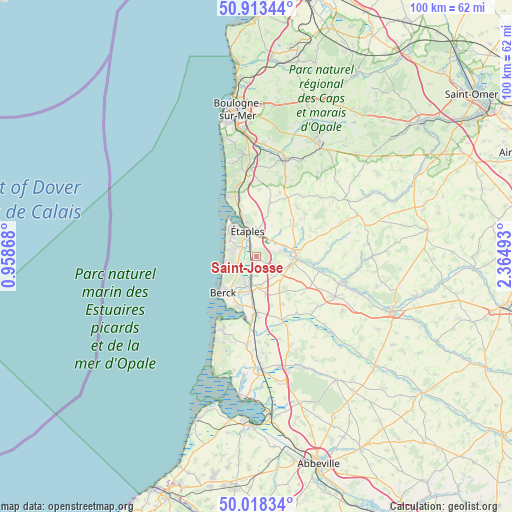
Saint-Josse GPS coordinates[2]
50° 28' 4.836" North, 1° 39' 42.48" East
| Map corner | latitude | longitude |
|---|---|---|
| Upper-left | 50.91344°, | 0.95868° |
| Center: | 50.46801°, | 1.6618° |
| Lower-right: | 50.01834°, | 2.36493° |
| Map W x H: | 99.5×99.5 km | = 61.8×61.8mi |
| max Lat: | 51.07786° ⇑3% North |
| Saint-Josse: | 50.46801° |
| min Lat: | ⇓97% South 41.3874° |
| min Long | Saint-Josse | max Long |
| -5.08615° | 1.6618° | 9.52242° |
| W 39.1%⇐ | ⇒60.9% E |
Elevation
Elevation of Saint-Josse is 37 m = 121 ft, and this is 156.7 m = 514 ft below average elevation for this country.
| Max E: |
2333 m = 7654 ft | 87.1% |
| Avg. | 193.7 m = 635 ft | |
| Saint-Josse | 37 m = 121 ft | |
Min E: |
-1 m = -3 ft | 12.9% |
See also: France elevation on elevation.city.
Geographical zone
Saint-Josse is located in North temperate zone (between Tropic of Cancer and the Arctic Circle). Distance of this North polar circle is 1789.7 km =1112.1 mi to North.| Distance of | km | miles | from Saint-Josse |
|---|---|---|---|
| North Pole | 4395.5 | 2731.2 | to North |
| Arctic Circle | 1789.7 | 1112.1 | to North |
| Tropic Cancer | 3005.6 | 1867.6 | to South |
| Equator | 5611.5 | 3486.8 | to South |


Nearby cities:
15 places around Saint-Josse: (largest is in red/bold)
• Attin
6.3 km =3.9 mi,  70°
70°
• Berck
8.7 km =5.4 mi,  210°
210°
• Bréxent-Énocq
6.8 km =4.2 mi,  46°
46°
• Campigneulles-les-Petites
5.8 km =3.6 mi,  117°
117°
• Cucq
3.1 km =1.9 mi,  289°
289°
• La Calotterie
4.7 km =2.9 mi,  79°
79°
• Le Touquet-Paris-Plage
8.3 km =5.2 mi,  319°
319°
• Merlimont
3.7 km =2.3 mi,  248°
248°
• Montreuil
7.2 km =4.5 mi,  93°
93°
• Neuville-sous-Montreuil
8.2 km =5.1 mi, 84°
• Rang-du-Fliers
5.8 km =3.6 mi,  192°
192°
• Verton
7.4 km =4.6 mi, 187°
• Wailly-Beaucamp
7.8 km =4.8 mi,  144°
144°
• Écuires
7.5 km =4.7 mi,  106°
106°
• Étaples
6.3 km =3.9 mi,  341°
341°
Sources, notices
• [Note1] Compared only with cities in France existing in our database
• [Src1] Map data: © OpenStreetMap contributors (CC-BY-SA)
• [Src2] Other city data from geonames.org with taken over terms of usage.
• [Src3] Geographical zone / Annual Mean Temperature by Robert A. Rohde @ Wikipedia
