Bréxent-Énocq geodata
Bréxent-Énocq (Hauts-de-France) is a populated place; located in France in Europe/Paris (GMT+2) time zone. With population of 598 people, there are 13354 cities with bigger population in this country. Compared to other cities in France, 97.4% of cities are located further ↓South; 60.1% of cities are located further →East and 95.7% of cities have higher elevation than Bréxent-Énocq. Note1
Administrative division(s):
- Level 1: Hauts-de-France
- Level 2: Pas-de-Calais
- Level 3: Arrondissement de Montreuil
- Level 4: Bréxent-Énocq


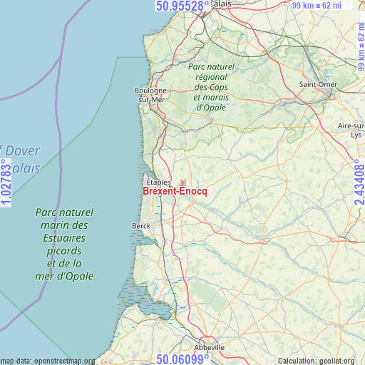
Bréxent-Énocq GPS coordinates[2]
50° 30' 36.9" North, 1° 43' 51.42" East
| Map corner | latitude | longitude |
|---|---|---|
| Upper-left | 50.95528°, | 1.02783° |
| Center: | 50.51025°, | 1.73095° |
| Lower-right: | 50.06099°, | 2.43408° |
| Map W x H: | 99.4×99.4 km | = 61.8×61.8mi |
| max Lat: | 51.07786° ⇑2.6% North |
| Bréxent-Énocq: | 50.51025° |
| min Lat: | ⇓97.4% South 41.3874° |
| min Long | Bréxent-Énocq | max Long |
| -5.08615° | 1.73095° | 9.52242° |
| W 39.9%⇐ | ⇒60.1% E |
Elevation
Elevation of Bréxent-Énocq is 15 m = 49 ft, and this is 178.7 m = 586 ft below average elevation for this country.
| Max E: |
2333 m = 7654 ft | 95.7% |
| Avg. | 193.7 m = 635 ft | |
| Bréxent-Énocq | 15 m = 49 ft | |
Min E: |
-1 m = -3 ft | 4.3% |
See also: France elevation on elevation.city.
Geographical zone
Bréxent-Énocq is located in North temperate zone (between Tropic of Cancer and the Arctic Circle). Distance of this North polar circle is 1785 km =1109.1 mi to North.| Distance of | km | miles | from Bréxent-Énocq |
|---|---|---|---|
| North Pole | 4390.8 | 2728.3 | to North |
| Arctic Circle | 1785 | 1109.1 | to North |
| Tropic Cancer | 3010.3 | 1870.5 | to South |
| Equator | 5616.2 | 3489.7 | to South |


Nearby cities:
15 places around Bréxent-Énocq: (largest is in red/bold)
• Attin
2.8 km =1.7 mi,  157°
157°
• Brimeux
10.5 km =6.5 mi,  135°
135°
• Camiers
10.8 km =6.7 mi,  309°
309°
• Campigneulles-les-Petites
7.4 km =4.6 mi,  177°
177°
• Cucq
8.6 km =5.3 mi,  244°
244°
• Frencq
6 km =3.7 mi,  338°
338°
• La Calotterie
3.9 km =2.4 mi, 184°
• Le Touquet-Paris-Plage
10.4 km =6.5 mi,  278°
278°
• Merlimont
10.3 km =6.4 mi,  234°
234°
• Montreuil
5.7 km =3.5 mi, 156°
• Neuville-sous-Montreuil
5.1 km =3.2 mi, 140°
• Saint-Josse
6.8 km =4.2 mi, 226°
• Wailly-Beaucamp
11.1 km =6.9 mi, 181°
• Écuires
7.2 km =4.5 mi, 161°
• Étaples
7 km =4.3 mi, 280°
Sources, notices
• [Note1] Compared only with cities in France existing in our database
• [Src1] Map data: © OpenStreetMap contributors (CC-BY-SA)
• [Src2] Other city data from geonames.org with taken over terms of usage.
• [Src3] Geographical zone / Annual Mean Temperature by Robert A. Rohde @ Wikipedia
