Étaples geodata
Étaples (Hauts-de-France) is a populated place; located in France in Europe/Paris (GMT+2) time zone. With population of 11,397 people, there are 846 cities with bigger population in this country. Compared to other cities in France, 97.5% of cities are located further ↓South; 61.2% of cities are located further →East and 96.3% of cities have higher elevation than Étaples. Note1
Administrative division(s):
- Level 1: Hauts-de-France
- Level 2: Pas-de-Calais
- Level 3: Arrondissement de Montreuil
- Level 4: Étaples


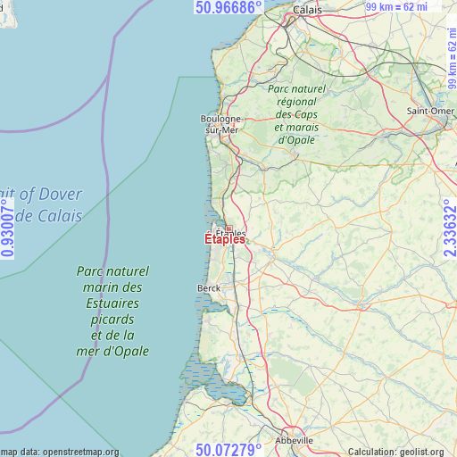
Étaples GPS coordinates[2]
50° 31' 18.984" North, 1° 37' 59.484" East
| Map corner | latitude | longitude |
|---|---|---|
| Upper-left | 50.96686°, | 0.93007° |
| Center: | 50.52194°, | 1.63319° |
| Lower-right: | 50.07279°, | 2.33632° |
| Map W x H: | 99.4×99.4 km | = 61.8×61.8mi |
| max Lat: | 51.07786° ⇑2.5% North |
| Étaples: | 50.52194° |
| min Lat: | ⇓97.5% South 41.3874° |
| min Long | Étaples | max Long |
| -5.08615° | 1.63319° | 9.52242° |
| W 38.8%⇐ | ⇒61.2% E |
Elevation
Elevation of Étaples is 13 m = 43 ft, and this is 180.7 m = 593 ft below average elevation for this country.
| Max E: |
2333 m = 7654 ft | 96.3% |
| Avg. | 193.7 m = 635 ft | |
| Étaples | 13 m = 43 ft | |
Min E: |
-1 m = -3 ft | 3.7% |
See also: France elevation on elevation.city.
Geographical zone
Étaples is located in North temperate zone (between Tropic of Cancer and the Arctic Circle). Distance of this North polar circle is 1783.7 km =1108.3 mi to North.| Distance of | km | miles | from Étaples |
|---|---|---|---|
| North Pole | 4389.5 | 2727.5 | to North |
| Arctic Circle | 1783.7 | 1108.3 | to North |
| Tropic Cancer | 3011.6 | 1871.3 | to South |
| Equator | 5617.5 | 3490.6 | to South |


Nearby cities:
15 places around Étaples: (largest is in red/bold)
• Attin
8.9 km =5.5 mi,  115°
115°
• Bréxent-Énocq
7 km =4.3 mi,  100°
100°
• Camiers
5.7 km =3.5 mi,  345°
345°
• Campigneulles-les-Petites
11.3 km =7 mi,  140°
140°
• Cucq
5 km =3.1 mi,  190°
190°
• Dannes
7.5 km =4.7 mi, 349°
• Frencq
6.4 km =4 mi,  47°
47°
• La Calotterie
8.4 km =5.2 mi,  128°
128°
• Le Touquet-Paris-Plage
3.4 km =2.1 mi,  274°
274°
• Merlimont
7.5 km =4.7 mi, 190°
• Montreuil
11.3 km =7 mi, 125°
• Nesles
11.7 km =7.3 mi,  8°
8°
• Neufchâtel-Hardelot
10.9 km =6.8 mi,  3°
3°
• Neuville-sous-Montreuil
11.4 km =7.1 mi, 117°
• Saint-Josse
6.3 km =3.9 mi,  161°
161°
Sources, notices
• [Note1] Compared only with cities in France existing in our database
• [Src1] Map data: © OpenStreetMap contributors (CC-BY-SA)
• [Src2] Other city data from geonames.org with taken over terms of usage.
• [Src3] Geographical zone / Annual Mean Temperature by Robert A. Rohde @ Wikipedia
