Marcheprime geodata
Marcheprime (Nouvelle-Aquitaine) is a populated place; located in France in Europe/Paris (GMT+2) time zone. With population of 3,768 people, there are 2603 cities with bigger population in this country. Compared to other cities in France, 82.2% of cities are located further ↑North; 86.9% of cities are located further →East and 80.2% of cities have higher elevation than Marcheprime. Note1
Administrative division(s):
- Level 1: Nouvelle-Aquitaine
- Level 2: Gironde
- Level 3: Arrondissement d'Arcachon
- Level 4: Marcheprime


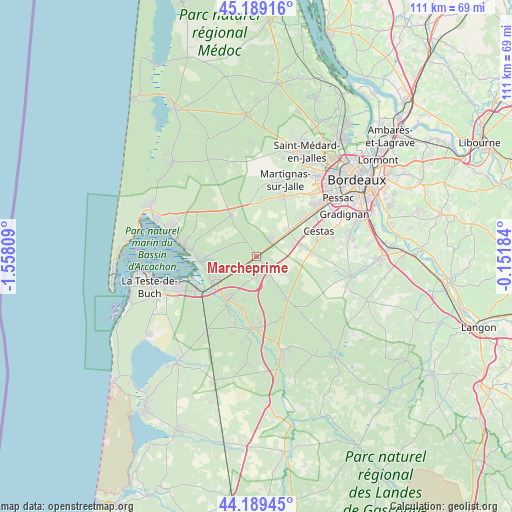
Marcheprime GPS coordinates[2]
44° 41' 29.256" North, 0° 51' 17.856" West
| Map corner | latitude | longitude |
|---|---|---|
| Upper-left | 45.18916°, | -1.55809° |
| Center: | 44.69146°, | -0.85496° |
| Lower-right: | 44.18945°, | -0.15184° |
| Map W x H: | 111.2×111.2 km | = 69.1×69.1mi |
| max Lat: | 51.07786° ⇑82.2% North |
| Marcheprime: | 44.69146° |
| min Lat: | ⇓17.8% South 41.3874° |
| min Long | Marcheprime | max Long |
| -5.08615° | -0.85496° | 9.52242° |
| W 13.1%⇐ | ⇒86.9% E |
Elevation
Elevation of Marcheprime is 54 m = 177 ft, and this is 139.7 m = 458 ft below average elevation for this country.
| Max E: |
2333 m = 7654 ft | 80.2% |
| Avg. | 193.7 m = 635 ft | |
| Marcheprime | 54 m = 177 ft | |
Min E: |
-1 m = -3 ft | 19.8% |
See also: France elevation on elevation.city.
Geographical zone
Marcheprime is located in North temperate zone (between Tropic of Cancer and the Arctic Circle). Distance of this Northern Tropic circle is 2363.3 km =1468.5 mi to South.| Distance of | km | miles | from Marcheprime |
|---|---|---|---|
| North Pole | 5037.8 | 3130.3 | to North |
| Arctic Circle | 2431.9 | 1511.1 | to North |
| Tropic Cancer | 2363.3 | 1468.5 | to South |
| Equator | 4969.2 | 3087.7 | to South |


Nearby cities:
15 places around Marcheprime: (largest is in red/bold)
• Andernos-les-Bains
20.5 km =12.7 mi,  287°
287°
• Audenge
12.5 km =7.8 mi,  267°
267°
• Biganos
10.7 km =6.6 mi,  241°
241°
• Canéjan
19.4 km =12.1 mi,  64°
64°
• Cestas
15.1 km =9.4 mi,  67°
67°
• Gujan-Mestras
17.9 km =11.1 mi,  248°
248°
• Lanton
14.4 km =8.9 mi,  275°
275°
• Le Barp
11.5 km =7.1 mi,  143°
143°
• Le Teich
14.8 km =9.2 mi, 243°
• Léognan
20.9 km =13 mi,  76°
76°
• Martignas-sur-Jalle
18.1 km =11.2 mi,  18°
18°
• Mios
11.4 km =7.1 mi,  212°
212°
• Saint-Jean-d’Illac
14.1 km =8.8 mi, 22°
• Salles
15.7 km =9.8 mi,  181°
181°
• Saucats
20.9 km =13 mi,  101°
101°
Sources, notices
• [Note1] Compared only with cities in France existing in our database
• [Src1] Map data: © OpenStreetMap contributors (CC-BY-SA)
• [Src2] Other city data from geonames.org with taken over terms of usage.
• [Src3] Geographical zone / Annual Mean Temperature by Robert A. Rohde @ Wikipedia
