Sautron geodata
Sautron (Pays de la Loire) is a populated place; located in France in Europe/Paris (GMT+2) time zone. With population of 7,405 people, there are 1321 cities with bigger population in this country. Compared to other cities in France, 52.1% of cities are located further ↑North; 93.3% of cities are located further →East and 74.6% of cities have higher elevation than Sautron. Note1
Administrative division(s):
- Level 1: Pays de la Loire
- Level 2: Loire-Atlantique
- Level 3: Arrondissement de Nantes
- Level 4: Sautron


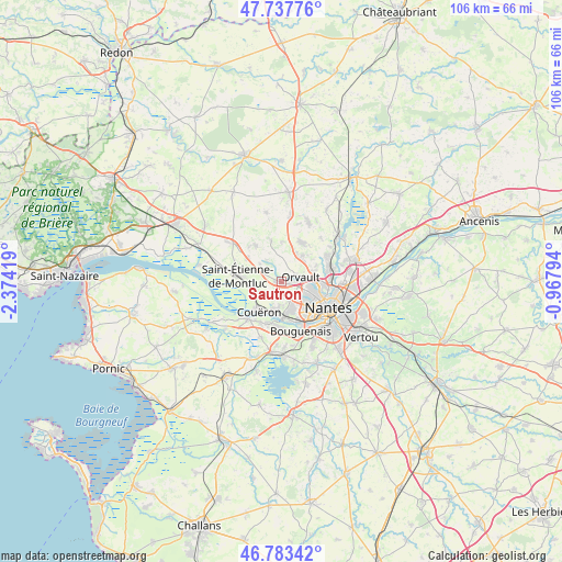
Sautron GPS coordinates[2]
47° 15' 45.864" North, 1° 40' 15.852" West
| Map corner | latitude | longitude |
|---|---|---|
| Upper-left | 47.73776°, | -2.37419° |
| Center: | 47.26274°, | -1.67107° |
| Lower-right: | 46.78342°, | -0.96794° |
| Map W x H: | 106.1×106.1 km | = 65.9×65.9mi |
| max Lat: | 51.07786° ⇑52.1% North |
| Sautron: | 47.26274° |
| min Lat: | ⇓47.9% South 41.3874° |
| min Long | Sautron | max Long |
| -5.08615° | -1.67107° | 9.52242° |
| W 6.7%⇐ | ⇒93.3% E |
Elevation
Elevation of Sautron is 68 m = 223 ft, and this is 125.7 m = 412 ft below average elevation for this country.
| Max E: |
2333 m = 7654 ft | 74.6% |
| Avg. | 193.7 m = 635 ft | |
| Sautron | 68 m = 223 ft | |
Min E: |
-1 m = -3 ft | 25.4% |
See also: France elevation on elevation.city.
Geographical zone
Sautron is located in North temperate zone (between Tropic of Cancer and the Arctic Circle). Distance of this North polar circle is 2146.1 km =1333.5 mi to North.| Distance of | km | miles | from Sautron |
|---|---|---|---|
| North Pole | 4751.9 | 2952.7 | to North |
| Arctic Circle | 2146.1 | 1333.5 | to North |
| Tropic Cancer | 2649.2 | 1646.1 | to South |
| Equator | 5255.1 | 3265.4 | to South |


Nearby cities:
15 places around Sautron: (largest is in red/bold)
• Bouguenais
10.2 km =6.3 mi,  158°
158°
• Brains
11.2 km =7 mi,  200°
200°
• Couëron
6.5 km =4 mi,  215°
215°
• Indre
7 km =4.3 mi,  177°
177°
• La Chapelle-sur-Erdre
9.6 km =6 mi,  67°
67°
• La Montagne
8.5 km =5.3 mi,  185°
185°
• Le Pellerin
9.5 km =5.9 mi, 221°
• Le Temple-de-Bretagne
11.4 km =7.1 mi,  308°
308°
• Nantes
10.2 km =6.3 mi,  119°
119°
• Orvault
3.8 km =2.4 mi,  76°
76°
• Saint-Herblain
5.3 km =3.3 mi, 161°
• Saint-Jean-de-Boiseau
8.7 km =5.4 mi,  207°
207°
• Saint-Étienne-de-Montluc
8.4 km =5.2 mi,  280°
280°
• Treillières
8.5 km =5.3 mi,  27°
27°
• Vigneux-de-Bretagne
8.6 km =5.3 mi,  324°
324°
Sources, notices
• [Note1] Compared only with cities in France existing in our database
• [Src1] Map data: © OpenStreetMap contributors (CC-BY-SA)
• [Src2] Other city data from geonames.org with taken over terms of usage.
• [Src3] Geographical zone / Annual Mean Temperature by Robert A. Rohde @ Wikipedia
