Saint-Igny-de-Vers geodata
Saint-Igny-de-Vers (Auvergne-Rhône-Alpes) is a populated place; located in France in Europe/Paris (GMT+2) time zone. With population of 590 people, there are 13479 cities with bigger population in this country. Compared to other cities in France, 63% of cities are located further ↑North; 71.6% of cities are located further ←West and 94% of cities have lower elevation than Saint-Igny-de-Vers. Note1
Administrative division(s):
- Level 1: Auvergne-Rhône-Alpes
- Level 2: Département du Rhône
- Level 3: Arrondissement de Villefranche-sur-Saône
- Level 4: Saint-Igny-de-Vers


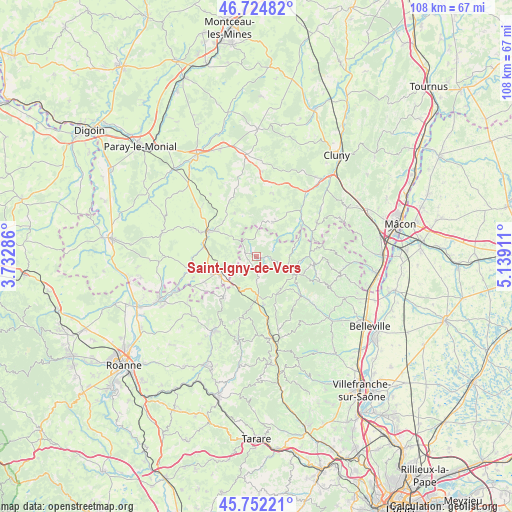
Saint-Igny-de-Vers GPS coordinates[2]
46° 14' 26.412" North, 4° 26' 9.528" East
| Map corner | latitude | longitude |
|---|---|---|
| Upper-left | 46.72482°, | 3.73286° |
| Center: | 46.24067°, | 4.43598° |
| Lower-right: | 45.75221°, | 5.13911° |
| Map W x H: | 108.1×108.1 km | = 67.2×67.2mi |
| max Lat: | 51.07786° ⇑63% North |
| Saint-Igny-de-Vers: | 46.24067° |
| min Lat: | ⇓37% South 41.3874° |
| min Long | Saint-Igny-de-V | max Long |
| -5.08615° | 4.43598° | 9.52242° |
| W 71.6%⇐ | ⇒28.4% E |
Elevation
Elevation of Saint-Igny-de-Vers is 541 m = 1775 ft, and this is 347.3 m = 1139 ft above average elevation for this country.
| Max E: |
2333 m = 7654 ft | 6% |
| Saint-Igny-de-Vers | 541 m 1775 ft | |
| Avg. | 193.7 m = 635 ft | |
Min E: |
-1 m = -3 ft | 94% |
See also: France elevation on elevation.city.
Geographical zone
Saint-Igny-de-Vers is located in North temperate zone (between Tropic of Cancer and the Arctic Circle). Distance of this North polar circle is 2259.7 km =1404.1 mi to North.| Distance of | km | miles | from Saint-Igny-de-Vers |
|---|---|---|---|
| North Pole | 4865.6 | 3023.3 | to North |
| Arctic Circle | 2259.7 | 1404.1 | to North |
| Tropic Cancer | 2535.6 | 1575.5 | to South |
| Equator | 5141.5 | 3194.8 | to South |


Nearby cities:
15 places around Saint-Igny-de-Vers: (largest is in red/bold)
• Baudemont
12.6 km =7.8 mi,  294°
294°
• Belmont-de-la-Loire
10.7 km =6.6 mi,  219°
219°
• Chassigny-sous-Dun
10.9 km =6.8 mi,  269°
269°
• Chauffailles
8.3 km =5.2 mi,  243°
243°
• Coublanc
14.5 km =9 mi, 239°
• Dompierre-les-Ormes
13.8 km =8.6 mi,  15°
15°
• Gibles
10.3 km =6.4 mi,  334°
334°
• La Clayette
11.5 km =7.1 mi,  298°
298°
• Les Ardillats
10.6 km =6.6 mi,  130°
130°
• Matour
8.1 km =5 mi,  25°
25°
• Monsols
6.9 km =4.3 mi,  110°
110°
• Poule-les-Écharmeaux
10.3 km =6.4 mi,  170°
170°
• Saint-Igny-de-Roche
12.1 km =7.5 mi, 244°
• Saint-Maurice-lès-Châteauneuf
14.3 km =8.9 mi,  259°
259°
• Varennes-sous-Dun
9.6 km =6 mi, 304°
Sources, notices
• [Note1] Compared only with cities in France existing in our database
• [Src1] Map data: © OpenStreetMap contributors (CC-BY-SA)
• [Src2] Other city data from geonames.org with taken over terms of usage.
• [Src3] Geographical zone / Annual Mean Temperature by Robert A. Rohde @ Wikipedia
