Matour geodata
Matour (Bourgogne-Franche-Comté) is a populated place; located in France in Europe/Paris (GMT+2) time zone. With population of 1,014 people, there are 8739 cities with bigger population in this country. Compared to other cities in France, 62.2% of cities are located further ↑North; 72% of cities are located further ←West and 90.2% of cities have lower elevation than Matour. Note1
Administrative division(s):
- Level 1: Bourgogne-Franche-Comté
- Level 2: Département de Saône-et-Loire
- Level 3: Arrondissement de Mâcon
- Level 4: Matour


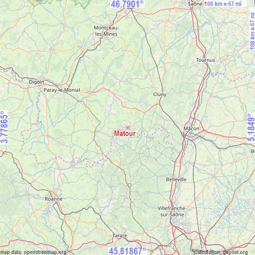
Matour GPS coordinates[2]
46° 18' 23.544" North, 4° 28' 54.408" East
| Map corner | latitude | longitude |
|---|---|---|
| Upper-left | 46.7901°, | 3.77865° |
| Center: | 46.30654°, | 4.48178° |
| Lower-right: | 45.81867°, | 5.1849° |
| Map W x H: | 108×108 km | = 67.1×67.1mi |
| max Lat: | 51.07786° ⇑62.2% North |
| Matour: | 46.30654° |
| min Lat: | ⇓37.8% South 41.3874° |
| min Long | Matour | max Long |
| -5.08615° | 4.48178° | 9.52242° |
| W 72%⇐ | ⇒28% E |
Elevation
Elevation of Matour is 431 m = 1414 ft, and this is 237.3 m = 779 ft above average elevation for this country.
| Max E: |
2333 m = 7654 ft | 9.8% |
| Matour | 431 m 1414 ft | |
| Avg. | 193.7 m = 635 ft | |
Min E: |
-1 m = -3 ft | 90.2% |
See also: France elevation on elevation.city.
Geographical zone
Matour is located in North temperate zone (between Tropic of Cancer and the Arctic Circle). Distance of this North polar circle is 2252.4 km =1399.6 mi to North.| Distance of | km | miles | from Matour |
|---|---|---|---|
| North Pole | 4858.3 | 3018.8 | to North |
| Arctic Circle | 2252.4 | 1399.6 | to North |
| Tropic Cancer | 2542.9 | 1580.1 | to South |
| Equator | 5148.8 | 3199.3 | to South |


Nearby cities:
15 places around Matour: (largest is in red/bold)
• Baudemont
15.1 km =9.4 mi,  262°
262°
• Bussières
17.7 km =11 mi,  78°
78°
• Chassigny-sous-Dun
16.2 km =10.1 mi,  242°
242°
• Chauffailles
15.6 km =9.7 mi,  224°
224°
• Dompierre-les-Ormes
6 km =3.7 mi,  1°
1°
• Gibles
8.2 km =5.1 mi,  283°
283°
• La Clayette
13.8 km =8.6 mi, 262°
• Les Ardillats
14.8 km =9.2 mi,  162°
162°
• Monsols
10.1 km =6.3 mi, 163°
• Pierreclos
16 km =9.9 mi, 78°
• Poule-les-Écharmeaux
17.6 km =10.9 mi,  186°
186°
• Saint-Igny-de-Vers
8.1 km =5 mi,  205°
205°
• Tramayes
9.3 km =5.8 mi,  91°
91°
• Varennes-sous-Dun
11.6 km =7.2 mi, 260°
• Verosvres
11 km =6.8 mi,  340°
340°
Sources, notices
• [Note1] Compared only with cities in France existing in our database
• [Src1] Map data: © OpenStreetMap contributors (CC-BY-SA)
• [Src2] Other city data from geonames.org with taken over terms of usage.
• [Src3] Geographical zone / Annual Mean Temperature by Robert A. Rohde @ Wikipedia
