Chauffailles geodata
Chauffailles (Bourgogne-Franche-Comté) is a populated place; located in France in Europe/Paris (GMT+2) time zone. With population of 4,184 people, there are 2347 cities with bigger population in this country. Compared to other cities in France, 63.4% of cities are located further ↑North; 70.9% of cities are located further ←West and 88.9% of cities have lower elevation than Chauffailles. Note1
Administrative division(s):
- Level 1: Bourgogne-Franche-Comté
- Level 2: Département de Saône-et-Loire
- Level 3: Arrondissement de Charolles
- Level 4: Chauffailles


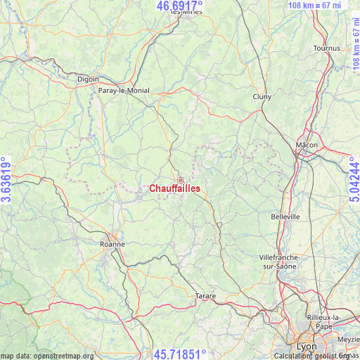
Chauffailles GPS coordinates[2]
46° 12' 26.136" North, 4° 20' 21.552" East
| Map corner | latitude | longitude |
|---|---|---|
| Upper-left | 46.6917°, | 3.63619° |
| Center: | 46.20726°, | 4.33932° |
| Lower-right: | 45.71851°, | 5.04244° |
| Map W x H: | 108.2×108.2 km | = 67.2×67.2mi |
| max Lat: | 51.07786° ⇑63.4% North |
| Chauffailles: | 46.20726° |
| min Lat: | ⇓36.6% South 41.3874° |
| min Long | Chauffailles | max Long |
| -5.08615° | 4.33932° | 9.52242° |
| W 70.9%⇐ | ⇒29.1% E |
Elevation
Elevation of Chauffailles is 405 m = 1329 ft, and this is 211.3 m = 693 ft above average elevation for this country.
| Max E: |
2333 m = 7654 ft | 11.1% |
| Chauffailles | 405 m 1329 ft | |
| Avg. | 193.7 m = 635 ft | |
Min E: |
-1 m = -3 ft | 88.9% |
See also: France elevation on elevation.city.
Geographical zone
Chauffailles is located in North temperate zone (between Tropic of Cancer and the Arctic Circle). Distance of this North polar circle is 2263.4 km =1406.4 mi to North.| Distance of | km | miles | from Chauffailles |
|---|---|---|---|
| North Pole | 4869.3 | 3025.6 | to North |
| Arctic Circle | 2263.4 | 1406.4 | to North |
| Tropic Cancer | 2531.8 | 1573.2 | to South |
| Equator | 5137.8 | 3192.5 | to South |


Nearby cities:
15 places around Chauffailles: (largest is in red/bold)
• Baudemont
9.8 km =6.1 mi,  335°
335°
• Belmont-de-la-Loire
4.6 km =2.9 mi,  172°
172°
• Chandon
11.6 km =7.2 mi,  236°
236°
• Chassigny-sous-Dun
5 km =3.1 mi,  315°
315°
• Coublanc
6.2 km =3.9 mi,  234°
234°
• Cuinzier
10.5 km =6.5 mi,  211°
211°
• La Clayette
9.6 km =6 mi, 343°
• Le Cergne
9.8 km =6.1 mi,  193°
193°
• Mars
9.4 km =5.8 mi, 230°
• Poule-les-Écharmeaux
11.2 km =7 mi,  125°
125°
• Saint-Denis-de-Cabanne
10.4 km =6.5 mi,  248°
248°
• Saint-Igny-de-Roche
3.8 km =2.4 mi, 247°
• Saint-Igny-de-Vers
8.3 km =5.2 mi,  63°
63°
• Saint-Maurice-lès-Châteauneuf
6.7 km =4.2 mi,  278°
278°
• Varennes-sous-Dun
9.2 km =5.7 mi,  356°
356°
Sources, notices
• [Note1] Compared only with cities in France existing in our database
• [Src1] Map data: © OpenStreetMap contributors (CC-BY-SA)
• [Src2] Other city data from geonames.org with taken over terms of usage.
• [Src3] Geographical zone / Annual Mean Temperature by Robert A. Rohde @ Wikipedia
