Châtel geodata
Châtel (Auvergne-Rhône-Alpes) is a populated place; located in France in Europe/Paris (GMT+2) time zone. With population of 1,309 people, there are 6984 cities with bigger population in this country. Compared to other cities in France, 62.7% of cities are located further ↑North; 93.9% of cities are located further ←West and 99.8% of cities have lower elevation than Châtel. Note1
Administrative division(s):
- Level 1: Auvergne-Rhône-Alpes
- Level 2: Haute-Savoie
- Level 3: Arrondissement de Thonon-les-Bains
- Level 4: Châtel


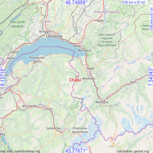
Châtel GPS coordinates[2]
46° 15' 53.82" North, 6° 50' 25.08" East
| Map corner | latitude | longitude |
|---|---|---|
| Upper-left | 46.74888°, | 6.13718° |
| Center: | 46.26495°, | 6.8403° |
| Lower-right: | 45.77671°, | 7.54343° |
| Map W x H: | 108.1×108.1 km | = 67.2×67.2mi |
| max Lat: | 51.07786° ⇑62.7% North |
| Châtel: | 46.26495° |
| min Lat: | ⇓37.3% South 41.3874° |
| min Long | Châtel | max Long |
| -5.08615° | 6.8403° | 9.52242° |
| W 93.9%⇐ | ⇒6.1% E |
Elevation
Elevation of Châtel is 1371 m = 4498 ft, and this is 1177.3 m = 3863 ft above average elevation for this country.
| Max E: |
2333 m = 7654 ft | 0.2% |
| Châtel | 1371 m 4498 ft | |
| Avg. | 193.7 m = 635 ft | |
Min E: |
-1 m = -3 ft | 99.8% |
See also: France elevation on elevation.city.
Geographical zone
Châtel is located in North temperate zone (between Tropic of Cancer and the Arctic Circle). Distance of this North polar circle is 2257 km =1402.4 mi to North.| Distance of | km | miles | from Châtel |
|---|---|---|---|
| North Pole | 4862.9 | 3021.7 | to North |
| Arctic Circle | 2257 | 1402.4 | to North |
| Tropic Cancer | 2538.3 | 1577.2 | to South |
| Equator | 5144.2 | 3196.5 | to South |


Nearby cities:
15 places around Châtel: (largest is in red/bold)
• Abondance
9.3 km =5.8 mi,  279°
279°
• Bernex
16.5 km =10.3 mi,  310°
310°
• Chevenoz
17.7 km =11 mi,  298°
298°
• Les Gets
18.2 km =11.3 mi,  227°
227°
• Lugrin
21 km =13 mi,  316°
316°
• Maxilly-sur-Léman
21.9 km =13.6 mi, 312°
• Montriond
13.7 km =8.5 mi,  238°
238°
• Morzine
13.9 km =8.6 mi, 227°
• Saint-Gingolph
14.6 km =9.1 mi,  346°
346°
• Saint-Jean-d’Aulps
14.8 km =9.2 mi,  256°
256°
• Saint-Paul-en-Chablais
20.9 km =13 mi, 307°
• Samoëns
22.1 km =13.7 mi,  203°
203°
• Thollon-les-Mémises
16.2 km =10.1 mi, 324°
• Vacheresse
14.5 km =9 mi, 297°
• Vinzier
19.4 km =12.1 mi, 298°
Sources, notices
• [Note1] Compared only with cities in France existing in our database
• [Src1] Map data: © OpenStreetMap contributors (CC-BY-SA)
• [Src2] Other city data from geonames.org with taken over terms of usage.
• [Src3] Geographical zone / Annual Mean Temperature by Robert A. Rohde @ Wikipedia
