Bignoux geodata
Bignoux (Nouvelle-Aquitaine) is a populated place; located in France in Europe/Paris (GMT+2) time zone. With population of 1,052 people, there are 8449 cities with bigger population in this country. Compared to other cities in France, 59.2% of cities are located further ↑North; 73.7% of cities are located further →East and 54.1% of cities have higher elevation than Bignoux. Note1
Administrative division(s):
- Level 1: Nouvelle-Aquitaine
- Level 2: Vienne
- Level 3: Arrondissement de Poitiers
- Level 4: Bignoux


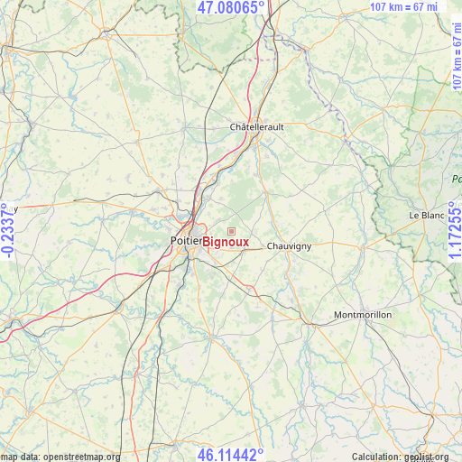
Bignoux GPS coordinates[2]
46° 35' 58.884" North, 0° 28' 9.948" East
| Map corner | latitude | longitude |
|---|---|---|
| Upper-left | 47.08065°, | -0.2337° |
| Center: | 46.59969°, | 0.46943° |
| Lower-right: | 46.11442°, | 1.17255° |
| Map W x H: | 107.4×107.4 km | = 66.7×66.7mi |
| max Lat: | 51.07786° ⇑59.2% North |
| Bignoux: | 46.59969° |
| min Lat: | ⇓40.8% South 41.3874° |
| min Long | Bignoux | max Long |
| -5.08615° | 0.46943° | 9.52242° |
| W 26.3%⇐ | ⇒73.7% E |
Elevation
Elevation of Bignoux is 119 m = 390 ft, and this is 74.7 m = 245 ft below average elevation for this country.
| Max E: |
2333 m = 7654 ft | 54.1% |
| Avg. | 193.7 m = 635 ft | |
| Bignoux | 119 m = 390 ft | |
Min E: |
-1 m = -3 ft | 45.9% |
See also: France elevation on elevation.city.
Geographical zone
Bignoux is located in North temperate zone (between Tropic of Cancer and the Arctic Circle). Distance of this North polar circle is 2219.8 km =1379.3 mi to North.| Distance of | km | miles | from Bignoux |
|---|---|---|---|
| North Pole | 4825.7 | 2998.6 | to North |
| Arctic Circle | 2219.8 | 1379.3 | to North |
| Tropic Cancer | 2575.5 | 1600.3 | to South |
| Equator | 5181.4 | 3219.6 | to South |


Nearby cities:
15 places around Bignoux: (largest is in red/bold)
• Bonnes
9.6 km =6 mi,  86°
86°
• Buxerolles
2.2 km =1.4 mi,  29°
29°
• Chasseneuil-du-Poitou
9.4 km =5.8 mi,  307°
307°
• Jardres
8 km =5 mi,  115°
115°
• La Chapelle-Moulière
9.2 km =5.7 mi,  52°
52°
• Lavoux
4.6 km =2.9 mi, 94°
• Liniers
5.3 km =3.3 mi,  76°
76°
• Mignaloux-Beauvoir
7.6 km =4.7 mi,  213°
213°
• Montamisé
4.2 km =2.6 mi, 305°
• Poitiers
9.8 km =6.1 mi,  258°
258°
• Pouillé
10.8 km =6.7 mi,  130°
130°
• Roman catholic diocese of Poitiers
9.5 km =5.9 mi, 256°
• Saint-Georges-lès-Baillargeaux
9.6 km =6 mi,  325°
325°
• Savigny-Lévescault
7.1 km =4.4 mi,  175°
175°
• Sèvres-Anxaumont
3.4 km =2.1 mi,  185°
185°
Sources, notices
• [Note1] Compared only with cities in France existing in our database
• [Src1] Map data: © OpenStreetMap contributors (CC-BY-SA)
• [Src2] Other city data from geonames.org with taken over terms of usage.
• [Src3] Geographical zone / Annual Mean Temperature by Robert A. Rohde @ Wikipedia
