Saint-Georges-de-Reintembault geodata
Saint-Georges-de-Reintembault (Brittany) is a populated place; located in France in Europe/Paris (GMT+2) time zone. With population of 1,841 people, there are 5145 cities with bigger population in this country. Compared to other cities in France, 68.5% of cities are located further ↓South; 90.3% of cities are located further →East and 51.1% of cities have lower elevation than Saint-Georges-de-Reintembault. Note1
Administrative division(s):
- Level 1: Brittany
- Level 2: Département d'Ille-et-Vilaine
- Level 3: Arrondissement de Fougères-Vitré
- Level 4: Saint-Georges-de-Reintembault
Current local time in Saint-Georges-de-Reintembault:
11:21 PM, SaturdayDifference from your time zone: hours


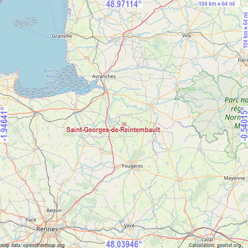
Saint-Georges-de-Reintembault GPS coordinates[2]
48° 30' 26.784" North, 1° 14' 35.808" West
| Map corner | latitude | longitude |
|---|---|---|
| Upper-left | 48.97114°, | -1.94641° |
| Center: | 48.50744°, | -1.24328° |
| Lower-right: | 48.03946°, | -0.54015° |
| Map W x H: | 103.6×103.6 km | = 64.4×64.4mi |
| max Lat: | 51.07786° ⇑31.5% North |
| Saint-Georges-de-Reintembault: | 48.50744° |
| min Lat: | ⇓68.5% South 41.3874° |
| min Long | Saint-Georges-d | max Long |
| -5.08615° | -1.24328° | 9.52242° |
| W 9.7%⇐ | ⇒90.3% E |
Elevation
Elevation of Saint-Georges-de-Reintembault is 136 m = 446 ft, and this is 57.7 m = 189 ft below average elevation for this country.
| Max E: |
2333 m = 7654 ft | 48.9% |
| Avg. | 193.7 m = 635 ft | |
| Saint-Georges-de-Reintembault | 136 m = 446 ft | |
Min E: |
-1 m = -3 ft | 51.1% |
See also: France elevation on elevation.city.
Geographical zone
Saint-Georges-de-Reintembault is located in North temperate zone (between Tropic of Cancer and the Arctic Circle). Distance of this North polar circle is 2007.7 km =1247.5 mi to North.| Distance of | km | miles | from Saint-Georges-de-Reintembault |
|---|---|---|---|
| North Pole | 4613.5 | 2866.7 | to North |
| Arctic Circle | 2007.7 | 1247.5 | to North |
| Tropic Cancer | 2787.6 | 1732.1 | to South |
| Equator | 5393.5 | 3351.4 | to South |


Nearby cities:
15 places around Saint-Georges-de-Reintembault: (largest is in red/bold)
• Argouges
11.3 km =7 mi,  267°
267°
• Coglès
10.5 km =6.5 mi,  238°
238°
• Le Ferré
4.1 km =2.5 mi,  246°
246°
• Les Loges-Marchis
12.1 km =7.5 mi,  71°
71°
• Louvigné-du-Désert
9.2 km =5.7 mi,  109°
109°
• Mellé
4.6 km =2.9 mi,  119°
119°
• Montours
8.7 km =5.4 mi,  213°
213°
• Parigné
9.7 km =6 mi,  157°
157°
• Saint-Aubin-de-Terregatte
8.7 km =5.4 mi,  331°
331°
• Saint-Brice-de-Landelles
7.2 km =4.5 mi, 67°
• Saint-Germain-en-Coglès
11.5 km =7.1 mi,  187°
187°
• Saint-James
6.3 km =3.9 mi,  284°
284°
• Saint-Laurent-de-Terregatte
7.2 km =4.5 mi,  350°
350°
• Saint-Martin-de-Landelles
6.7 km =4.2 mi,  51°
51°
• Virey
11.8 km =7.3 mi,  43°
43°
Sources, notices
• [Note1] Compared only with cities in France existing in our database
• [Src1] Map data: © OpenStreetMap contributors (CC-BY-SA)
• [Src2] Other city data from geonames.org with taken over terms of usage.
• [Src3] Geographical zone / Annual Mean Temperature by Robert A. Rohde @ Wikipedia
