Virey geodata
Virey (Normandy) is a populated place; located in France in Europe/Paris (GMT+2) time zone. With population of 953 people, there are 9182 cities with bigger population in this country. Compared to other cities in France, 70.5% of cities are located further ↓South; 89.5% of cities are located further →East and 58.3% of cities have higher elevation than Virey. Note1
Administrative division(s):
- Level 1: Normandy
- Level 2: Manche
- Level 3: Avranches
- Level 4: Saint-Hilaire-du-Harcouët


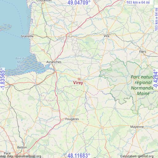
Virey GPS coordinates[2]
48° 35' 2.76" North, 1° 7' 57.072" West
| Map corner | latitude | longitude |
|---|---|---|
| Upper-left | 49.04709°, | -1.83565° |
| Center: | 48.5841°, | -1.13252° |
| Lower-right: | 48.11683°, | -0.4294° |
| Map W x H: | 103.4×103.4 km | = 64.2×64.2mi |
| max Lat: | 51.07786° ⇑29.5% North |
| Virey: | 48.5841° |
| min Lat: | ⇓70.5% South 41.3874° |
| min Long | Virey | max Long |
| -5.08615° | -1.13252° | 9.52242° |
| W 10.5%⇐ | ⇒89.5% E |
Elevation
Elevation of Virey is 107 m = 351 ft, and this is 86.7 m = 284 ft below average elevation for this country.
| Max E: |
2333 m = 7654 ft | 58.3% |
| Avg. | 193.7 m = 635 ft | |
| Virey | 107 m = 351 ft | |
Min E: |
-1 m = -3 ft | 41.7% |
See also: France elevation on elevation.city.
Geographical zone
Virey is located in North temperate zone (between Tropic of Cancer and the Arctic Circle). Distance of this North polar circle is 1999.1 km =1242.2 mi to North.| Distance of | km | miles | from Virey |
|---|---|---|---|
| North Pole | 4605 | 2861.4 | to North |
| Arctic Circle | 1999.1 | 1242.2 | to North |
| Tropic Cancer | 2796.1 | 1737.4 | to South |
| Equator | 5402 | 3356.6 | to South |


Nearby cities:
15 places around Virey: (largest is in red/bold)
• Ducey
12.2 km =7.6 mi,  288°
288°
• Isigny-le-Buat
4.6 km =2.9 mi,  323°
323°
• Le Grand-Celland
11.4 km =7.1 mi,  340°
340°
• Les Loges-Marchis
5.8 km =3.6 mi,  145°
145°
• Louvigné-du-Désert
11.5 km =7.1 mi,  177°
177°
• Mellé
11.5 km =7.1 mi,  201°
201°
• Parigny
4.1 km =2.5 mi,  73°
73°
• Reffuveille
9.5 km =5.9 mi,  8°
8°
• Saint-Aubin-de-Terregatte
12.3 km =7.6 mi,  265°
265°
• Saint-Brice-de-Landelles
5.9 km =3.7 mi,  194°
194°
• Saint-Georges-de-Reintembault
11.8 km =7.3 mi,  223°
223°
• Saint-Hilaire-du-Harcouët
3.2 km =2 mi,  104°
104°
• Saint-Laurent-de-Terregatte
9.4 km =5.8 mi,  261°
261°
• Saint-Martin-de-Landelles
5.2 km =3.2 mi,  214°
214°
• Savigny-le-Vieux
9.3 km =5.8 mi,  138°
138°
Sources, notices
• [Note1] Compared only with cities in France existing in our database
• [Src1] Map data: © OpenStreetMap contributors (CC-BY-SA)
• [Src2] Other city data from geonames.org with taken over terms of usage.
• [Src3] Geographical zone / Annual Mean Temperature by Robert A. Rohde @ Wikipedia
