Argouges geodata
Argouges (Normandy) is a populated place; located in France in Europe/Paris (GMT+2) time zone. With population of 553 people, there are 14157 cities with bigger population in this country. Compared to other cities in France, 68.4% of cities are located further ↓South; 91.5% of cities are located further →East and 85.3% of cities have higher elevation than Argouges. Note1
Administrative division(s):
- Level 1: Normandy
- Level 2: Manche
- Level 3: Avranches
- Level 4: Saint-James


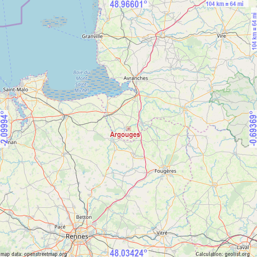
Argouges GPS coordinates[2]
48° 30' 8.172" North, 1° 23' 48.552" West
| Map corner | latitude | longitude |
|---|---|---|
| Upper-left | 48.96601°, | -2.09994° |
| Center: | 48.50227°, | -1.39682° |
| Lower-right: | 48.03424°, | -0.69369° |
| Map W x H: | 103.6×103.6 km | = 64.4×64.4mi |
| max Lat: | 51.07786° ⇑31.6% North |
| Argouges: | 48.50227° |
| min Lat: | ⇓68.4% South 41.3874° |
| min Long | Argouges | max Long |
| -5.08615° | -1.39682° | 9.52242° |
| W 8.5%⇐ | ⇒91.5% E |
Elevation
Elevation of Argouges is 41 m = 135 ft, and this is 152.7 m = 501 ft below average elevation for this country.
| Max E: |
2333 m = 7654 ft | 85.3% |
| Avg. | 193.7 m = 635 ft | |
| Argouges | 41 m = 135 ft | |
Min E: |
-1 m = -3 ft | 14.7% |
See also: France elevation on elevation.city.
Geographical zone
Argouges is located in North temperate zone (between Tropic of Cancer and the Arctic Circle). Distance of this North polar circle is 2008.2 km =1247.8 mi to North.| Distance of | km | miles | from Argouges |
|---|---|---|---|
| North Pole | 4614.1 | 2867.1 | to North |
| Arctic Circle | 2008.2 | 1247.8 | to North |
| Tropic Cancer | 2787 | 1731.8 | to South |
| Equator | 5392.9 | 3351 | to South |


Nearby cities:
15 places around Argouges: (largest is in red/bold)
• Antrain
7.9 km =4.9 mi,  233°
233°
• Coglès
5.4 km =3.4 mi,  154°
154°
• La Fontenelle
8.8 km =5.5 mi,  243°
243°
• Le Ferré
7.6 km =4.7 mi,  98°
98°
• Montours
9.3 km =5.8 mi,  135°
135°
• Pontorson
9.9 km =6.2 mi,  304°
304°
• Sacey
4 km =2.5 mi,  280°
280°
• Saint-Aubin-de-Terregatte
10.9 km =6.8 mi,  41°
41°
• Saint-Brice-en-Coglès
10.3 km =6.4 mi,  168°
168°
• Saint-Georges-de-Reintembault
11.3 km =7 mi,  87°
87°
• Saint-James
5.6 km =3.5 mi,  67°
67°
• Saint-Laurent-de-Terregatte
12.7 km =7.9 mi,  52°
52°
• Saint-Étienne-en-Coglès
12.3 km =7.6 mi,  155°
155°
• Sougéal
9.4 km =5.8 mi, 275°
• Tremblay
10.6 km =6.6 mi,  213°
213°
Sources, notices
• [Note1] Compared only with cities in France existing in our database
• [Src1] Map data: © OpenStreetMap contributors (CC-BY-SA)
• [Src2] Other city data from geonames.org with taken over terms of usage.
• [Src3] Geographical zone / Annual Mean Temperature by Robert A. Rohde @ Wikipedia
