Saint-Forgeux geodata
Saint-Forgeux (Auvergne-Rhône-Alpes) is a populated place; located in France in Europe/Paris (GMT+2) time zone. With population of 1,436 people, there are 6450 cities with bigger population in this country. Compared to other cities in France, 68.3% of cities are located further ↑North; 71.9% of cities are located further ←West and 89.6% of cities have lower elevation than Saint-Forgeux. Note1
Administrative division(s):
- Level 1: Auvergne-Rhône-Alpes
- Level 2: Département du Rhône
- Level 3: Arrondissement de Villefranche-sur-Saône
- Level 4: Saint-Forgeux


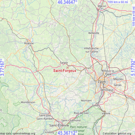
Saint-Forgeux GPS coordinates[2]
45° 51' 32.22" North, 4° 28' 29.28" East
| Map corner | latitude | longitude |
|---|---|---|
| Upper-left | 46.34647°, | 3.77167° |
| Center: | 45.85895°, | 4.4748° |
| Lower-right: | 45.36712°, | 5.17792° |
| Map W x H: | 108.9×108.9 km | = 67.7×67.7mi |
| max Lat: | 51.07786° ⇑68.3% North |
| Saint-Forgeux: | 45.85895° |
| min Lat: | ⇓31.7% South 41.3874° |
| min Long | Saint-Forgeux | max Long |
| -5.08615° | 4.4748° | 9.52242° |
| W 71.9%⇐ | ⇒28.1% E |
Elevation
Elevation of Saint-Forgeux is 419 m = 1375 ft, and this is 225.3 m = 739 ft above average elevation for this country.
| Max E: |
2333 m = 7654 ft | 10.4% |
| Saint-Forgeux | 419 m 1375 ft | |
| Avg. | 193.7 m = 635 ft | |
Min E: |
-1 m = -3 ft | 89.6% |
See also: France elevation on elevation.city.
Geographical zone
Saint-Forgeux is located in North temperate zone (between Tropic of Cancer and the Arctic Circle). Distance of this North polar circle is 2302.1 km =1430.5 mi to North.| Distance of | km | miles | from Saint-Forgeux |
|---|---|---|---|
| North Pole | 4908 | 3049.7 | to North |
| Arctic Circle | 2302.1 | 1430.5 | to North |
| Tropic Cancer | 2493.1 | 1549.1 | to South |
| Equator | 5099 | 3168.4 | to South |


Nearby cities:
15 places around Saint-Forgeux: (largest is in red/bold)
• Ancy
3.5 km =2.2 mi,  133°
133°
• Bully
8.4 km =5.2 mi,  95°
95°
• Les Olmes
4.2 km =2.6 mi,  50°
50°
• Longessaigne
8.4 km =5.2 mi,  207°
207°
• Montrottier
7.7 km =4.8 mi,  184°
184°
• Pontcharra-sur-Turdine
2.1 km =1.3 mi,  34°
34°
• Saint-Clément-sur-Valsonne
7.4 km =4.6 mi,  347°
347°
• Saint-Julien-sur-Bibost
7 km =4.3 mi,  150°
150°
• Saint-Loup
4.1 km =2.5 mi,  15°
15°
• Saint-Marcel-l’Éclairé
3.6 km =2.2 mi,  299°
299°
• Saint-Romain-de-Popey
4.6 km =2.9 mi,  106°
106°
• Saint-Vérand
7.8 km =4.8 mi, 31°
• Sarcey
6.5 km =4 mi,  68°
68°
• Tarare
5.3 km =3.3 mi,  321°
321°
• Villechenève
7.4 km =4.6 mi,  226°
226°
Sources, notices
• [Note1] Compared only with cities in France existing in our database
• [Src1] Map data: © OpenStreetMap contributors (CC-BY-SA)
• [Src2] Other city data from geonames.org with taken over terms of usage.
• [Src3] Geographical zone / Annual Mean Temperature by Robert A. Rohde @ Wikipedia
