Saint-Loup geodata
Saint-Loup (Auvergne-Rhône-Alpes) is a populated place; located in France in Europe/Paris (GMT+2) time zone. With population of 922 people, there are 9460 cities with bigger population in this country. Compared to other cities in France, 67.7% of cities are located further ↑North; 72% of cities are located further ←West and 90.2% of cities have lower elevation than Saint-Loup. Note1
Administrative division(s):
- Level 1: Auvergne-Rhône-Alpes
- Level 2: Département du Rhône
- Level 3: Arrondissement de Villefranche-sur-Saône
- Level 4: Vindry-sur-Turdine


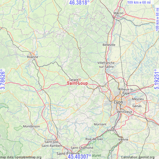
Saint-Loup GPS coordinates[2]
45° 53' 40.524" North, 4° 29' 21.768" East
| Map corner | latitude | longitude |
|---|---|---|
| Upper-left | 46.3818°, | 3.78626° |
| Center: | 45.89459°, | 4.48938° |
| Lower-right: | 45.40307°, | 5.19251° |
| Map W x H: | 108.8×108.8 km | = 67.6×67.6mi |
| max Lat: | 51.07786° ⇑67.7% North |
| Saint-Loup: | 45.89459° |
| min Lat: | ⇓32.3% South 41.3874° |
| min Long | Saint-Loup | max Long |
| -5.08615° | 4.48938° | 9.52242° |
| W 72%⇐ | ⇒28% E |
Elevation
Elevation of Saint-Loup is 430 m = 1411 ft, and this is 236.3 m = 775 ft above average elevation for this country.
| Max E: |
2333 m = 7654 ft | 9.8% |
| Saint-Loup | 430 m 1411 ft | |
| Avg. | 193.7 m = 635 ft | |
Min E: |
-1 m = -3 ft | 90.2% |
See also: France elevation on elevation.city.
Geographical zone
Saint-Loup is located in North temperate zone (between Tropic of Cancer and the Arctic Circle). Distance of this North polar circle is 2298.2 km =1428 mi to North.| Distance of | km | miles | from Saint-Loup |
|---|---|---|---|
| North Pole | 4904.1 | 3047.3 | to North |
| Arctic Circle | 2298.2 | 1428 | to North |
| Tropic Cancer | 2497.1 | 1551.6 | to South |
| Equator | 5103 | 3170.9 | to South |


Nearby cities:
15 places around Saint-Loup: (largest is in red/bold)
• Ancy
6.5 km =4 mi,  167°
167°
• Le Bois-d'Oingt
7.6 km =4.7 mi,  70°
70°
• Les Olmes
2.4 km =1.5 mi,  120°
120°
• Létra
8 km =5 mi,  19°
19°
• Pontcharra-sur-Turdine
2.3 km =1.4 mi,  179°
179°
• Saint-Clément-sur-Valsonne
4.2 km =2.6 mi,  320°
320°
• Saint-Forgeux
4.1 km =2.5 mi,  195°
195°
• Saint-Laurent-d’Oingt
8 km =5 mi,  45°
45°
• Saint-Marcel-l’Éclairé
4.8 km =3 mi,  242°
242°
• Saint-Romain-de-Popey
6.2 km =3.9 mi,  148°
148°
• Saint-Vérand
4 km =2.5 mi, 47°
• Sarcey
5.1 km =3.2 mi,  107°
107°
• Tarare
4.4 km =2.7 mi,  272°
272°
• Ternand
6.3 km =3.9 mi,  28°
28°
• Valsonne
7.4 km =4.6 mi, 321°
Sources, notices
• [Note1] Compared only with cities in France existing in our database
• [Src1] Map data: © OpenStreetMap contributors (CC-BY-SA)
• [Src2] Other city data from geonames.org with taken over terms of usage.
• [Src3] Geographical zone / Annual Mean Temperature by Robert A. Rohde @ Wikipedia
