Saint-Vérand geodata
Saint-Vérand (Auvergne-Rhône-Alpes) is a populated place; located in France in Europe/Paris (GMT+2) time zone. With population of 1,047 people, there are 8486 cities with bigger population in this country. Compared to other cities in France, 67.3% of cities are located further ↑North; 72.3% of cities are located further ←West and 86.2% of cities have lower elevation than Saint-Vérand. Note1
Administrative division(s):
- Level 1: Auvergne-Rhône-Alpes
- Level 2: Département du Rhône
- Level 3: Arrondissement de Villefranche-sur-Saône
- Level 4: Saint-Vérand


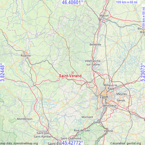
Saint-Vérand GPS coordinates[2]
45° 55' 8.472" North, 4° 31' 39.396" East
| Map corner | latitude | longitude |
|---|---|---|
| Upper-left | 46.40601°, | 3.82448° |
| Center: | 45.91902°, | 4.52761° |
| Lower-right: | 45.42772°, | 5.23073° |
| Map W x H: | 108.8×108.8 km | = 67.6×67.6mi |
| max Lat: | 51.07786° ⇑67.3% North |
| Saint-Vérand: | 45.91902° |
| min Lat: | ⇓32.7% South 41.3874° |
| min Long | Saint-Vérand | max Long |
| -5.08615° | 4.52761° | 9.52242° |
| W 72.3%⇐ | ⇒27.7% E |
Elevation
Elevation of Saint-Vérand is 362 m = 1188 ft, and this is 168.3 m = 552 ft above average elevation for this country.
| Max E: |
2333 m = 7654 ft | 13.8% |
| Saint-Vérand | 362 m 1188 ft | |
| Avg. | 193.7 m = 635 ft | |
Min E: |
-1 m = -3 ft | 86.2% |
See also: France elevation on elevation.city.
Geographical zone
Saint-Vérand is located in North temperate zone (between Tropic of Cancer and the Arctic Circle). Distance of this North polar circle is 2295.5 km =1426.4 mi to North.| Distance of | km | miles | from Saint-Vérand |
|---|---|---|---|
| North Pole | 4901.3 | 3045.5 | to North |
| Arctic Circle | 2295.5 | 1426.4 | to North |
| Tropic Cancer | 2499.8 | 1553.3 | to South |
| Equator | 5105.7 | 3172.5 | to South |


Nearby cities:
15 places around Saint-Vérand: (largest is in red/bold)
• Bagnols
6.2 km =3.9 mi,  91°
91°
• Chamelet
7.3 km =4.5 mi,  349°
349°
• Frontenas
7 km =4.3 mi,  84°
84°
• Le Bois-d'Oingt
4.3 km =2.7 mi, 92°
• Les Olmes
4.1 km =2.5 mi,  192°
192°
• Létra
4.8 km =3 mi,  356°
356°
• Oingt
5.4 km =3.4 mi,  52°
52°
• Pontcharra-sur-Turdine
5.8 km =3.6 mi,  210°
210°
• Saint-Clément-sur-Valsonne
5.7 km =3.5 mi,  275°
275°
• Saint-Laurent-d’Oingt
3.9 km =2.4 mi,  44°
44°
• Saint-Loup
4 km =2.5 mi,  227°
227°
• Sarcey
4.7 km =2.9 mi,  155°
155°
• Tarare
7.7 km =4.8 mi,  250°
250°
• Ternand
2.8 km =1.7 mi,  1°
1°
• Theizé
7.2 km =4.5 mi,  71°
71°
Sources, notices
• [Note1] Compared only with cities in France existing in our database
• [Src1] Map data: © OpenStreetMap contributors (CC-BY-SA)
• [Src2] Other city data from geonames.org with taken over terms of usage.
• [Src3] Geographical zone / Annual Mean Temperature by Robert A. Rohde @ Wikipedia
