Saint-Forget geodata
Saint-Forget (Île-de-France) is a populated place; located in France in Europe/Paris (GMT+2) time zone. With population of 547 people, there are 14264 cities with bigger population in this country. Compared to other cities in France, 73.2% of cities are located further ↓South; 57.1% of cities are located further →East and 55.6% of cities have higher elevation than Saint-Forget. Note1
Administrative division(s):
- Level 1: Île-de-France
- Level 2: Yvelines
- Level 3: Arrondissement de Rambouillet
- Level 4: Saint-Forget


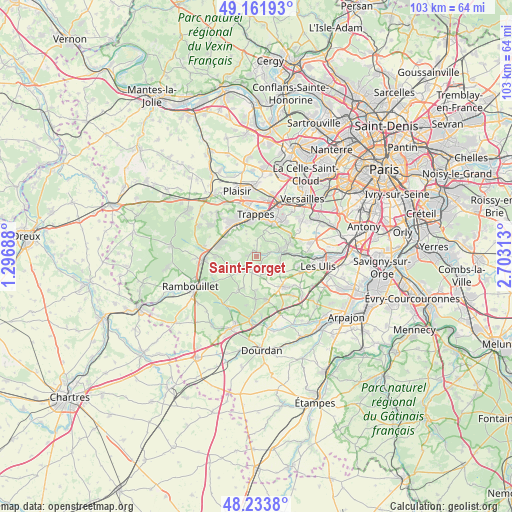
Saint-Forget GPS coordinates[2]
48° 42' 0" North, 2° 0' 0" East
| Map corner | latitude | longitude |
|---|---|---|
| Upper-left | 49.16193°, | 1.29688° |
| Center: | 48.7°, | 2° |
| Lower-right: | 48.2338°, | 2.70313° |
| Map W x H: | 103.2×103.2 km | = 64.1×64.1mi |
| max Lat: | 51.07786° ⇑26.8% North |
| Saint-Forget: | 48.7° |
| min Lat: | ⇓73.2% South 41.3874° |
| min Long | Saint-Forget | max Long |
| -5.08615° | 2° | 9.52242° |
| W 42.9%⇐ | ⇒57.1% E |
Elevation
Elevation of Saint-Forget is 115 m = 377 ft, and this is 78.7 m = 258 ft below average elevation for this country.
| Max E: |
2333 m = 7654 ft | 55.6% |
| Avg. | 193.7 m = 635 ft | |
| Saint-Forget | 115 m = 377 ft | |
Min E: |
-1 m = -3 ft | 44.4% |
See also: France elevation on elevation.city.
Geographical zone
Saint-Forget is located in North temperate zone (between Tropic of Cancer and the Arctic Circle). Distance of this North polar circle is 1986.2 km =1234.2 mi to North.| Distance of | km | miles | from Saint-Forget |
|---|---|---|---|
| North Pole | 4592.1 | 2853.4 | to North |
| Arctic Circle | 1986.2 | 1234.2 | to North |
| Tropic Cancer | 2809 | 1745.4 | to South |
| Equator | 5414.9 | 3364.7 | to South |


Nearby cities:
15 places around Saint-Forget: (largest is in red/bold)
• Boullay-les-Troux
4.3 km =2.7 mi,  123°
123°
• Cernay-la-Ville
3.5 km =2.2 mi,  212°
212°
• Chevreuse
2.6 km =1.6 mi,  73°
73°
• Choisel
1.9 km =1.2 mi,  135°
135°
• Dampierre-en-Yvelines
1.2 km =0.7 mi,  270°
270°
• La Verrière
7 km =4.3 mi,  325°
325°
• Le Mesnil-Saint-Denis
5.9 km =3.7 mi, 327°
• Les Essarts-le-Roi
7.5 km =4.7 mi,  284°
284°
• Les Molières
5.9 km =3.7 mi, 120°
• Lévis-Saint-Nom
4.1 km =2.5 mi,  296°
296°
• Magny-les-Hameaux
6.6 km =4.1 mi,  43°
43°
• Pecqueuse
6.9 km =4.3 mi,  149°
149°
• Saint-Rémy-lès-Chevreuse
5.7 km =3.5 mi,  82°
82°
• Senlisse
1.9 km =1.2 mi,  225°
225°
• Voisins-le-Bretonneux
7.5 km =4.7 mi,  30°
30°
Sources, notices
• [Note1] Compared only with cities in France existing in our database
• [Src1] Map data: © OpenStreetMap contributors (CC-BY-SA)
• [Src2] Other city data from geonames.org with taken over terms of usage.
• [Src3] Geographical zone / Annual Mean Temperature by Robert A. Rohde @ Wikipedia
