Saint-Rémy-lès-Chevreuse geodata
Saint-Rémy-lès-Chevreuse (Île-de-France) is a populated place; located in France in Europe/Paris (GMT+2) time zone. With population of 8,072 people, there are 1203 cities with bigger population in this country. Compared to other cities in France, 73.4% of cities are located further ↓South; 56.1% of cities are located further →East and 67.4% of cities have higher elevation than Saint-Rémy-lès-Chevreuse. Note1
Administrative division(s):
- Level 1: Île-de-France
- Level 2: Yvelines
- Level 3: Arrondissement de Rambouillet
- Level 4: Saint-Rémy-lès-Chevreuse
Current local time in Saint-Rémy-lès-Chevreuse:
05:51 AM, WednesdayDifference from your time zone: hours


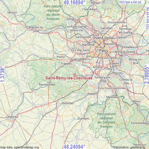
Saint-Rémy-lès-Chevreuse GPS coordinates[2]
48° 42' 25.488" North, 2° 4' 36.912" East
| Map corner | latitude | longitude |
|---|---|---|
| Upper-left | 49.16894°, | 1.3738° |
| Center: | 48.70708°, | 2.07692° |
| Lower-right: | 48.24094°, | 2.78005° |
| Map W x H: | 103.2×103.2 km | = 64.1×64.1mi |
| max Lat: | 51.07786° ⇑26.6% North |
| Saint-Rémy-lès-Chevreuse: | 48.70708° |
| min Lat: | ⇓73.4% South 41.3874° |
| min Long | Saint-Rémy-lè | max Long |
| -5.08615° | 2.07692° | 9.52242° |
| W 43.9%⇐ | ⇒56.1% E |
Elevation
Elevation of Saint-Rémy-lès-Chevreuse is 84 m = 276 ft, and this is 109.7 m = 360 ft below average elevation for this country.
| Max E: |
2333 m = 7654 ft | 67.4% |
| Avg. | 193.7 m = 635 ft | |
| Saint-Rémy-lès-Chevreuse | 84 m = 276 ft | |
Min E: |
-1 m = -3 ft | 32.6% |
See also: France elevation on elevation.city.
Geographical zone
Saint-Rémy-lès-Chevreuse is located in North temperate zone (between Tropic of Cancer and the Arctic Circle). Distance of this North polar circle is 1985.5 km =1233.7 mi to North.| Distance of | km | miles | from Saint-Rémy-lès-Chevreuse |
|---|---|---|---|
| North Pole | 4591.3 | 2852.9 | to North |
| Arctic Circle | 1985.5 | 1233.7 | to North |
| Tropic Cancer | 2809.8 | 1745.9 | to South |
| Equator | 5415.7 | 3365.2 | to South |


Nearby cities:
15 places around Saint-Rémy-lès-Chevreuse: (largest is in red/bold)
• Boullay-les-Troux
3.8 km =2.4 mi,  213°
213°
• Chevreuse
3.2 km =2 mi,  269°
269°
• Choisel
4.8 km =3 mi,  243°
243°
• Châteaufort
3.4 km =2.1 mi,  17°
17°
• Gif-sur-Yvette
4.9 km =3 mi,  122°
122°
• Gometz-la-Ville
5.4 km =3.4 mi,  135°
135°
• Gometz-le-Châtel
5.5 km =3.4 mi,  125°
125°
• Les Molières
3.8 km =2.4 mi,  188°
188°
• Limours
6.8 km =4.2 mi,  180°
180°
• Magny-les-Hameaux
4.2 km =2.6 mi,  344°
344°
• Saint-Aubin
4.8 km =3 mi,  81°
81°
• Saint-Forget
5.7 km =3.5 mi,  262°
262°
• Toussus-le-Noble
5.4 km =3.4 mi,  29°
29°
• Villiers-le-Bâcle
3.9 km =2.4 mi,  52°
52°
• Voisins-le-Bretonneux
6 km =3.7 mi, 341°
Sources, notices
• [Note1] Compared only with cities in France existing in our database
• [Src1] Map data: © OpenStreetMap contributors (CC-BY-SA)
• [Src2] Other city data from geonames.org with taken over terms of usage.
• [Src3] Geographical zone / Annual Mean Temperature by Robert A. Rohde @ Wikipedia
