Sainte-Sévère geodata
Sainte-Sévère (Nouvelle-Aquitaine) is a populated place; located in France in Europe/Paris (GMT+2) time zone. With population of 568 people, there are 13863 cities with bigger population in this country. Compared to other cities in France, 70% of cities are located further ↑North; 80.1% of cities are located further →East and 93.9% of cities have higher elevation than Sainte-Sévère. Note1
Administrative division(s):
- Level 1: Nouvelle-Aquitaine
- Level 2: Charente
- Level 3: Arrondissement de Cognac
- Level 4: Sainte-Sévère


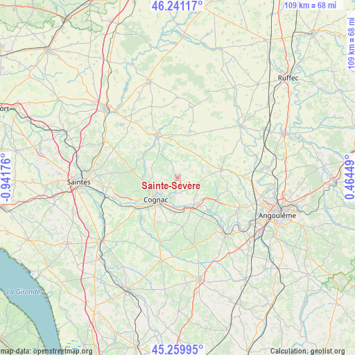
Sainte-Sévère GPS coordinates[2]
45° 45' 9.792" North, 0° 14' 19.068" West
| Map corner | latitude | longitude |
|---|---|---|
| Upper-left | 46.24117°, | -0.94176° |
| Center: | 45.75272°, | -0.23863° |
| Lower-right: | 45.25995°, | 0.46449° |
| Map W x H: | 109.1×109.1 km | = 67.8×67.8mi |
| max Lat: | 51.07786° ⇑70% North |
| Sainte-Sévère: | 45.75272° |
| min Lat: | ⇓30% South 41.3874° |
| min Long | Sainte-Sévère | max Long |
| -5.08615° | -0.23863° | 9.52242° |
| W 19.9%⇐ | ⇒80.1% E |
Elevation
Elevation of Sainte-Sévère is 20 m = 66 ft, and this is 173.7 m = 570 ft below average elevation for this country.
| Max E: |
2333 m = 7654 ft | 93.9% |
| Avg. | 193.7 m = 635 ft | |
| Sainte-Sévère | 20 m = 66 ft | |
Min E: |
-1 m = -3 ft | 6.1% |
See also: France elevation on elevation.city.
Geographical zone
Sainte-Sévère is located in North temperate zone (between Tropic of Cancer and the Arctic Circle). Distance of this North polar circle is 2313.9 km =1437.8 mi to North.| Distance of | km | miles | from Sainte-Sévère |
|---|---|---|---|
| North Pole | 4919.8 | 3057 | to North |
| Arctic Circle | 2313.9 | 1437.8 | to North |
| Tropic Cancer | 2481.3 | 1541.8 | to South |
| Equator | 5087.2 | 3161 | to South |


Nearby cities:
15 places around Sainte-Sévère: (largest is in red/bold)
• Bourg-Charente
9.6 km =6 mi,  177°
177°
• Boutiers-Saint-Trojan
6.2 km =3.9 mi,  229°
229°
• Bréville
5.2 km =3.2 mi,  339°
339°
• Chassors
6.1 km =3.8 mi,  163°
163°
• Cherves-Richemont
8.8 km =5.5 mi,  263°
263°
• Cognac
9.5 km =5.9 mi, 228°
• Courbillac
4.8 km =3 mi,  70°
70°
• Foussignac
10.3 km =6.4 mi,  112°
112°
• Jarnac
9.4 km =5.8 mi,  147°
147°
• Javrezac
10.4 km =6.5 mi,  235°
235°
• Nercillac
4.1 km =2.5 mi,  192°
192°
• Réparsac
2.6 km =1.6 mi, 176°
• Saint-Brice
8.5 km =5.3 mi,  204°
204°
• Sigogne
6.5 km =4 mi, 105°
• Sonnac
9.9 km =6.2 mi,  345°
345°
Sources, notices
• [Note1] Compared only with cities in France existing in our database
• [Src1] Map data: © OpenStreetMap contributors (CC-BY-SA)
• [Src2] Other city data from geonames.org with taken over terms of usage.
• [Src3] Geographical zone / Annual Mean Temperature by Robert A. Rohde @ Wikipedia
