Chassors geodata
Chassors (Nouvelle-Aquitaine) is a populated place; located in France in Europe/Paris (GMT+2) time zone. With population of 1,096 people, there are 8154 cities with bigger population in this country. Compared to other cities in France, 70.9% of cities are located further ↑North; 79.9% of cities are located further →East and 84.5% of cities have higher elevation than Chassors. Note1
Administrative division(s):
- Level 1: Nouvelle-Aquitaine
- Level 2: Charente
- Level 3: Arrondissement de Cognac
- Level 4: Chassors


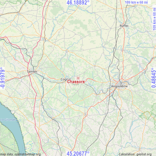
Chassors GPS coordinates[2]
45° 42' 0" North, 0° 13' 0.012" West
| Map corner | latitude | longitude |
|---|---|---|
| Upper-left | 46.18892°, | -0.91979° |
| Center: | 45.7°, | -0.21667° |
| Lower-right: | 45.20677°, | 0.48645° |
| Map W x H: | 109.2×109.2 km | = 67.9×67.9mi |
| max Lat: | 51.07786° ⇑70.9% North |
| Chassors: | 45.7° |
| min Lat: | ⇓29.1% South 41.3874° |
| min Long | Chassors | max Long |
| -5.08615° | -0.21667° | 9.52242° |
| W 20.1%⇐ | ⇒79.9% E |
Elevation
Elevation of Chassors is 43 m = 141 ft, and this is 150.7 m = 494 ft below average elevation for this country.
| Max E: |
2333 m = 7654 ft | 84.5% |
| Avg. | 193.7 m = 635 ft | |
| Chassors | 43 m = 141 ft | |
Min E: |
-1 m = -3 ft | 15.5% |
See also: France elevation on elevation.city.
Geographical zone
Chassors is located in North temperate zone (between Tropic of Cancer and the Arctic Circle). Distance of this North polar circle is 2319.8 km =1441.5 mi to North.| Distance of | km | miles | from Chassors |
|---|---|---|---|
| North Pole | 4925.7 | 3060.7 | to North |
| Arctic Circle | 2319.8 | 1441.5 | to North |
| Tropic Cancer | 2475.4 | 1538.1 | to South |
| Equator | 5081.4 | 3157.4 | to South |


Nearby cities:
15 places around Chassors: (largest is in red/bold)
• Bourg-Charente
3.9 km =2.4 mi,  199°
199°
• Boutiers-Saint-Trojan
6.7 km =4.2 mi,  285°
285°
• Cognac
8.7 km =5.4 mi,  266°
266°
• Courbillac
8 km =5 mi,  20°
20°
• Foussignac
8 km =5 mi,  76°
76°
• Gensac-la-Pallue
6.1 km =3.8 mi, 204°
• Gondeville
6.1 km =3.8 mi,  121°
121°
• Jarnac
3.9 km =2.4 mi, 121°
• Mainxe
7.9 km =4.9 mi,  160°
160°
• Nercillac
3.2 km =2 mi,  305°
305°
• Réparsac
3.7 km =2.3 mi,  335°
335°
• Saint-Brice
5.5 km =3.4 mi,  250°
250°
• Saint-Même-les-Carrières
7.6 km =4.7 mi,  137°
137°
• Sainte-Sévère
6.1 km =3.8 mi, 343°
• Sigogne
6.1 km =3.8 mi,  48°
48°
Sources, notices
• [Note1] Compared only with cities in France existing in our database
• [Src1] Map data: © OpenStreetMap contributors (CC-BY-SA)
• [Src2] Other city data from geonames.org with taken over terms of usage.
• [Src3] Geographical zone / Annual Mean Temperature by Robert A. Rohde @ Wikipedia
