Sainte-Blandine geodata
Sainte-Blandine (Auvergne-Rhône-Alpes) is a populated place; located in France in Europe/Paris (GMT+2) time zone. With population of 836 people, there are 10228 cities with bigger population in this country. Compared to other cities in France, 73.5% of cities are located further ↑North; 82.4% of cities are located further ←West and 91.3% of cities have lower elevation than Sainte-Blandine. Note1
Administrative division(s):
- Level 1: Auvergne-Rhône-Alpes
- Level 2: Département de l'Isère
- Level 3: Arrondissement de La Tour-du-Pin
- Level 4: Sainte-Blandine


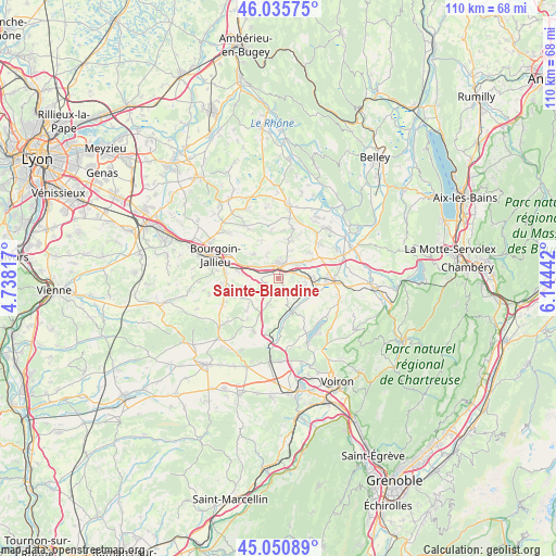
Sainte-Blandine GPS coordinates[2]
45° 32' 43.728" North, 5° 26' 28.644" East
| Map corner | latitude | longitude |
|---|---|---|
| Upper-left | 46.03575°, | 4.73817° |
| Center: | 45.54548°, | 5.44129° |
| Lower-right: | 45.05089°, | 6.14442° |
| Map W x H: | 109.5×109.5 km | = 68×68mi |
| max Lat: | 51.07786° ⇑73.5% North |
| Sainte-Blandine: | 45.54548° |
| min Lat: | ⇓26.5% South 41.3874° |
| min Long | Sainte-Blandine | max Long |
| -5.08615° | 5.44129° | 9.52242° |
| W 82.4%⇐ | ⇒17.6% E |
Elevation
Elevation of Sainte-Blandine is 457 m = 1499 ft, and this is 263.3 m = 864 ft above average elevation for this country.
| Max E: |
2333 m = 7654 ft | 8.7% |
| Sainte-Blandine | 457 m 1499 ft | |
| Avg. | 193.7 m = 635 ft | |
Min E: |
-1 m = -3 ft | 91.3% |
See also: France elevation on elevation.city.
Geographical zone
Sainte-Blandine is located in North temperate zone (between Tropic of Cancer and the Arctic Circle). Distance of this North polar circle is 2337 km =1452.1 mi to North.| Distance of | km | miles | from Sainte-Blandine |
|---|---|---|---|
| North Pole | 4942.9 | 3071.4 | to North |
| Arctic Circle | 2337 | 1452.1 | to North |
| Tropic Cancer | 2458.3 | 1527.5 | to South |
| Equator | 5064.2 | 3146.7 | to South |


Nearby cities:
15 places around Sainte-Blandine: (largest is in red/bold)
• Biol
7.4 km =4.6 mi,  215°
215°
• Cessieu
5.5 km =3.4 mi,  291°
291°
• Chélieu
4.6 km =2.9 mi,  144°
144°
• Doissin
5.1 km =3.2 mi,  201°
201°
• La Chapelle-de-la-Tour
4.7 km =2.9 mi,  21°
21°
• La Tour-du-Pin
2.3 km =1.4 mi,  6°
6°
• Le Passage
5.7 km =3.5 mi,  103°
103°
• Rochetoirin
4.8 km =3 mi,  332°
332°
• Saint-André-le-Gaz
6.8 km =4.2 mi,  90°
90°
• Saint-Clair-de-la-Tour
4.2 km =2.6 mi,  42°
42°
• Saint-Didier-de-la-Tour
3.3 km =2.1 mi,  66°
66°
• Saint-Jean-de-Soudain
2.7 km =1.7 mi,  338°
338°
• Saint-Victor-de-Cessieu
3.9 km =2.4 mi,  262°
262°
• Sérézin-de-la-Tour
7.4 km =4.6 mi,  279°
279°
• Virieu
7.3 km =4.5 mi,  158°
158°
Sources, notices
• [Note1] Compared only with cities in France existing in our database
• [Src1] Map data: © OpenStreetMap contributors (CC-BY-SA)
• [Src2] Other city data from geonames.org with taken over terms of usage.
• [Src3] Geographical zone / Annual Mean Temperature by Robert A. Rohde @ Wikipedia
