Biol geodata
Biol (Auvergne-Rhône-Alpes) is a populated place; located in France in Europe/Paris (GMT+2) time zone. With population of 1,343 people, there are 6854 cities with bigger population in this country. Compared to other cities in France, 74.2% of cities are located further ↑North; 81.7% of cities are located further ←West and 91.5% of cities have lower elevation than Biol. Note1
Administrative division(s):
- Level 1: Auvergne-Rhône-Alpes
- Level 2: Département de l'Isère
- Level 3: Arrondissement de La Tour-du-Pin
- Level 4: Biol


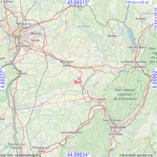
Biol GPS coordinates[2]
45° 29' 29.04" North, 5° 23' 7.8" East
| Map corner | latitude | longitude |
|---|---|---|
| Upper-left | 45.98215°, | 4.68237° |
| Center: | 45.4914°, | 5.3855° |
| Lower-right: | 44.99634°, | 6.08862° |
| Map W x H: | 109.6×109.6 km | = 68.1×68.1mi |
| max Lat: | 51.07786° ⇑74.2% North |
| Biol: | 45.4914° |
| min Lat: | ⇓25.8% South 41.3874° |
| min Long | Biol | max Long |
| -5.08615° | 5.3855° | 9.52242° |
| W 81.7%⇐ | ⇒18.3% E |
Elevation
Elevation of Biol is 464 m = 1522 ft, and this is 270.3 m = 887 ft above average elevation for this country.
| Max E: |
2333 m = 7654 ft | 8.5% |
| Biol | 464 m 1522 ft | |
| Avg. | 193.7 m = 635 ft | |
Min E: |
-1 m = -3 ft | 91.5% |
See also: France elevation on elevation.city.
Geographical zone
Biol is located in North temperate zone (between Tropic of Cancer and the Arctic Circle). Distance of this North polar circle is 2343 km =1455.9 mi to North.| Distance of | km | miles | from Biol |
|---|---|---|---|
| North Pole | 4948.9 | 3075.1 | to North |
| Arctic Circle | 2343 | 1455.9 | to North |
| Tropic Cancer | 2452.3 | 1523.8 | to South |
| Equator | 5058.2 | 3143 | to South |


Nearby cities:
15 places around Biol: (largest is in red/bold)
• Badinières
6.7 km =4.2 mi,  285°
285°
• Bizonnes
4.3 km =2.7 mi,  186°
186°
• Cessieu
8.1 km =5 mi,  354°
354°
• Champier
8.3 km =5.2 mi,  241°
241°
• Châbons
6.2 km =3.9 mi,  150°
150°
• Châteauvilain
5 km =3.1 mi,  300°
300°
• Chélieu
7.4 km =4.6 mi,  72°
72°
• Doissin
2.8 km =1.7 mi,  62°
62°
• Eclose
6.8 km =4.2 mi,  276°
276°
• Les Éparres
8.6 km =5.3 mi,  305°
305°
• Saint-Victor-de-Cessieu
5.5 km =3.4 mi,  4°
4°
• Sainte-Blandine
7.4 km =4.6 mi,  35°
35°
• Succieu
5.4 km =3.4 mi,  316°
316°
• Sérézin-de-la-Tour
7.8 km =4.8 mi,  337°
337°
• Virieu
7.1 km =4.4 mi,  96°
96°
Sources, notices
• [Note1] Compared only with cities in France existing in our database
• [Src1] Map data: © OpenStreetMap contributors (CC-BY-SA)
• [Src2] Other city data from geonames.org with taken over terms of usage.
• [Src3] Geographical zone / Annual Mean Temperature by Robert A. Rohde @ Wikipedia
