La Chapelle-de-la-Tour geodata
La Chapelle-de-la-Tour (Auvergne-Rhône-Alpes) is a populated place; located in France in Europe/Paris (GMT+2) time zone. With population of 1,566 people, there are 5950 cities with bigger population in this country. Compared to other cities in France, 72.8% of cities are located further ↑North; 82.6% of cities are located further ←West and 90.2% of cities have lower elevation than La Chapelle-de-la-Tour. Note1
Administrative division(s):
- Level 1: Auvergne-Rhône-Alpes
- Level 2: Département de l'Isère
- Level 3: Arrondissement de La Tour-du-Pin
- Level 4: La Chapelle-de-la-Tour
Current local time in La Chapelle-de-la-Tour:
11:25 AM, SaturdayDifference from your time zone: hours


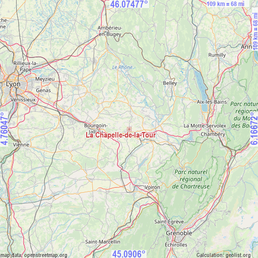
La Chapelle-de-la-Tour GPS coordinates[2]
45° 35' 5.424" North, 5° 27' 48.96" East
| Map corner | latitude | longitude |
|---|---|---|
| Upper-left | 46.07477°, | 4.76047° |
| Center: | 45.58484°, | 5.4636° |
| Lower-right: | 45.0906°, | 6.16672° |
| Map W x H: | 109.4×109.4 km | = 68×68mi |
| max Lat: | 51.07786° ⇑72.8% North |
| La Chapelle-de-la-Tour: | 45.58484° |
| min Lat: | ⇓27.2% South 41.3874° |
| min Long | La Chapelle-de- | max Long |
| -5.08615° | 5.4636° | 9.52242° |
| W 82.6%⇐ | ⇒17.4% E |
Elevation
Elevation of La Chapelle-de-la-Tour is 430 m = 1411 ft, and this is 236.3 m = 775 ft above average elevation for this country.
| Max E: |
2333 m = 7654 ft | 9.8% |
| La Chapelle-de-la-Tour | 430 m 1411 ft | |
| Avg. | 193.7 m = 635 ft | |
Min E: |
-1 m = -3 ft | 90.2% |
See also: France elevation on elevation.city.
Geographical zone
La Chapelle-de-la-Tour is located in North temperate zone (between Tropic of Cancer and the Arctic Circle). Distance of this North polar circle is 2332.6 km =1449.4 mi to North.| Distance of | km | miles | from La Chapelle-de-la-Tour |
|---|---|---|---|
| North Pole | 4938.5 | 3068.6 | to North |
| Arctic Circle | 2332.6 | 1449.4 | to North |
| Tropic Cancer | 2462.6 | 1530.2 | to South |
| Equator | 5068.6 | 3149.5 | to South |


Nearby cities:
15 places around La Chapelle-de-la-Tour: (largest is in red/bold)
• Corbelin
6.6 km =4.1 mi,  67°
67°
• Curtin
6.8 km =4.2 mi,  17°
17°
• Dolomieu
2.9 km =1.8 mi,  36°
36°
• Faverges-de-la-Tour
4.5 km =2.8 mi,  81°
81°
• La Bâtie-Montgascon
5.1 km =3.2 mi,  99°
99°
• La Tour-du-Pin
2.6 km =1.6 mi,  214°
214°
• Le Passage
6.8 km =4.2 mi,  146°
146°
• Rochetoirin
4 km =2.5 mi,  268°
268°
• Saint-André-le-Gaz
6.7 km =4.2 mi,  130°
130°
• Saint-Clair-de-la-Tour
1.7 km =1.1 mi,  139°
139°
• Saint-Didier-de-la-Tour
3.3 km =2.1 mi,  156°
156°
• Saint-Jean-de-Soudain
3.3 km =2.1 mi,  234°
234°
• Saint-Sorlin-de-Morestel
6 km =3.7 mi,  12°
12°
• Sainte-Blandine
4.7 km =2.9 mi,  201°
201°
• Vignieu
6.2 km =3.9 mi,  332°
332°
Sources, notices
• [Note1] Compared only with cities in France existing in our database
• [Src1] Map data: © OpenStreetMap contributors (CC-BY-SA)
• [Src2] Other city data from geonames.org with taken over terms of usage.
• [Src3] Geographical zone / Annual Mean Temperature by Robert A. Rohde @ Wikipedia
