Cessieu geodata
Cessieu (Auvergne-Rhône-Alpes) is a populated place; located in France in Europe/Paris (GMT+2) time zone. With population of 2,292 people, there are 4208 cities with bigger population in this country. Compared to other cities in France, 73.1% of cities are located further ↑North; 81.5% of cities are located further ←West and 81.9% of cities have lower elevation than Cessieu. Note1
Administrative division(s):
- Level 1: Auvergne-Rhône-Alpes
- Level 2: Département de l'Isère
- Level 3: Arrondissement de La Tour-du-Pin
- Level 4: Cessieu


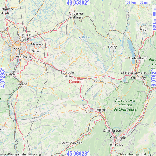
Cessieu GPS coordinates[2]
45° 33' 49.356" North, 5° 22' 33.852" East
| Map corner | latitude | longitude |
|---|---|---|
| Upper-left | 46.05382°, | 4.67295° |
| Center: | 45.56371°, | 5.37607° |
| Lower-right: | 45.06928°, | 6.0792° |
| Map W x H: | 109.5×109.5 km | = 68×68mi |
| max Lat: | 51.07786° ⇑73.1% North |
| Cessieu: | 45.56371° |
| min Lat: | ⇓26.9% South 41.3874° |
| min Long | Cessieu | max Long |
| -5.08615° | 5.37607° | 9.52242° |
| W 81.5%⇐ | ⇒18.5% E |
Elevation
Elevation of Cessieu is 310 m = 1017 ft, and this is 116.3 m = 382 ft above average elevation for this country.
| Max E: |
2333 m = 7654 ft | 18.1% |
| Cessieu | 310 m 1017 ft | |
| Avg. | 193.7 m = 635 ft | |
Min E: |
-1 m = -3 ft | 81.9% |
See also: France elevation on elevation.city.
Geographical zone
Cessieu is located in North temperate zone (between Tropic of Cancer and the Arctic Circle). Distance of this North polar circle is 2335 km =1450.9 mi to North.| Distance of | km | miles | from Cessieu |
|---|---|---|---|
| North Pole | 4940.9 | 3070.1 | to North |
| Arctic Circle | 2335 | 1450.9 | to North |
| Tropic Cancer | 2460.3 | 1528.8 | to South |
| Equator | 5066.2 | 3148 | to South |


Nearby cities:
15 places around Cessieu: (largest is in red/bold)
• Châteauvilain
6.5 km =4 mi,  213°
213°
• Doissin
7.5 km =4.7 mi,  154°
154°
• La Chapelle-de-la-Tour
7.2 km =4.5 mi,  70°
70°
• La Tour-du-Pin
5.4 km =3.4 mi,  87°
87°
• Les Éparres
7 km =4.3 mi,  244°
244°
• Meyrié
6.9 km =4.3 mi,  265°
265°
• Nivolas-Vermelle
5.5 km =3.4 mi,  264°
264°
• Rochetoirin
3.6 km =2.2 mi,  51°
51°
• Ruy
4.9 km =3 mi,  300°
300°
• Saint-Clair-de-la-Tour
8 km =5 mi,  82°
82°
• Saint-Jean-de-Soudain
4.1 km =2.5 mi, 83°
• Saint-Victor-de-Cessieu
2.8 km =1.7 mi,  155°
155°
• Sainte-Blandine
5.5 km =3.4 mi,  111°
111°
• Succieu
5 km =3.1 mi,  216°
216°
• Sérézin-de-la-Tour
2.4 km =1.5 mi,  248°
248°
Sources, notices
• [Note1] Compared only with cities in France existing in our database
• [Src1] Map data: © OpenStreetMap contributors (CC-BY-SA)
• [Src2] Other city data from geonames.org with taken over terms of usage.
• [Src3] Geographical zone / Annual Mean Temperature by Robert A. Rohde @ Wikipedia
