Saint-Dié-des-Vosges geodata
Saint-Dié-des-Vosges (Grand Est) is a seat of a third-order administrative division; located in France in Europe/Paris (GMT+2) time zone. With population of 24,628 people, there are 351 cities with bigger population in this country. Compared to other cities in France, 64.2% of cities are located further ↓South; 94.6% of cities are located further ←West and 84.8% of cities have lower elevation than Saint-Dié-des-Vosges. Note1
Administrative division(s):
- Level 1: Grand Est
- Level 2: Vosges
- Level 3: Arrondissement de Saint-Dié-des-Vosges
- Level 4: Saint-Dié-des-Vosges
Current local time in Saint-Dié-des-Vosges:
05:58 AM, WednesdayDifference from your time zone: hours


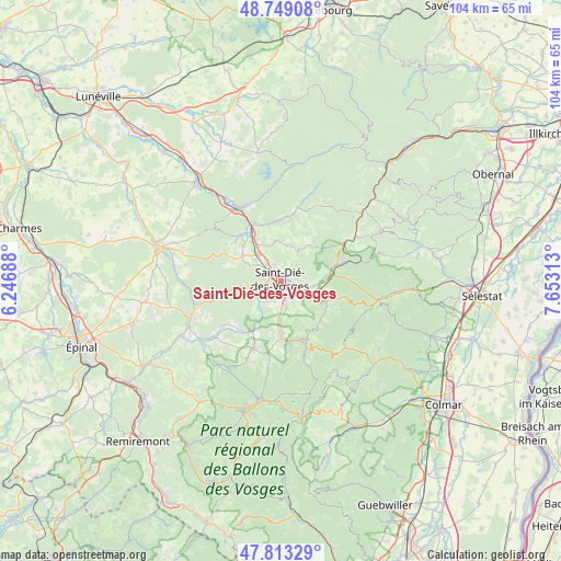
Saint-Dié-des-Vosges GPS coordinates[2]
48° 16' 59.988" North, 6° 57' 0" East
| Map corner | latitude | longitude |
|---|---|---|
| Upper-left | 48.74908°, | 6.24688° |
| Center: | 48.28333°, | 6.95° |
| Lower-right: | 47.81329°, | 7.65313° |
| Map W x H: | 104.1×10⁴ km | = 64.7×64.6mi |
| max Lat: | 51.07786° ⇑35.8% North |
| Saint-Dié-des-Vosges: | 48.28333° |
| min Lat: | ⇓64.2% South 41.3874° |
| min Long | Saint-Dié-des- | max Long |
| -5.08615° | 6.95° | 9.52242° |
| W 94.6%⇐ | ⇒5.4% E |
Elevation
Elevation of Saint-Dié-des-Vosges is 344 m = 1129 ft, and this is 150.3 m = 493 ft above average elevation for this country.
| Max E: |
2333 m = 7654 ft | 15.2% |
| Saint-Dié-des-Vosges | 344 m 1129 ft | |
| Avg. | 193.7 m = 635 ft | |
Min E: |
-1 m = -3 ft | 84.8% |
See also: France elevation on elevation.city.
Geographical zone
Saint-Dié-des-Vosges is located in North temperate zone (between Tropic of Cancer and the Arctic Circle). Distance of this North polar circle is 2032.6 km =1263 mi to North.| Distance of | km | miles | from Saint-Dié-des-Vosges |
|---|---|---|---|
| North Pole | 4638.5 | 2882.2 | to North |
| Arctic Circle | 2032.6 | 1263 | to North |
| Tropic Cancer | 2762.7 | 1716.7 | to South |
| Equator | 5368.6 | 3335.9 | to South |


Nearby cities:
15 places around Saint-Dié-des-Vosges: (largest is in red/bold)
• Anould
10.9 km =6.8 mi,  181°
181°
• Ban-de-Laveline
9.6 km =6 mi,  116°
116°
• La Bourgonce
9.6 km =6 mi,  289°
289°
• La Croix-aux-Mines
10.2 km =6.3 mi,  134°
134°
• La Voivre
6.4 km =4 mi,  326°
326°
• Mandray
7.8 km =4.8 mi,  155°
155°
• Moyenmoutier
11.1 km =6.9 mi,  340°
340°
• Nayemont-les-Fosses
4.5 km =2.8 mi,  70°
70°
• Nompatelize
8.6 km =5.3 mi,  302°
302°
• Provenchères-sur-Fave
9.9 km =6.2 mi, 74°
• Saint-Léonard
7.5 km =4.7 mi, 183°
• Saint-Michel-sur-Meurthe
6.2 km =3.9 mi,  314°
314°
• Sainte-Marguerite
3.1 km =1.9 mi, 124°
• Saulcy-sur-Meurthe
5.2 km =3.2 mi,  168°
168°
• Taintrux
5.3 km =3.3 mi,  224°
224°
Sources, notices
• [Note1] Compared only with cities in France existing in our database
• [Src1] Map data: © OpenStreetMap contributors (CC-BY-SA)
• [Src2] Other city data from geonames.org with taken over terms of usage.
• [Src3] Geographical zone / Annual Mean Temperature by Robert A. Rohde @ Wikipedia
