Provenchères-sur-Fave geodata
Provenchères-sur-Fave (Grand Est) is a populated place; located in France in Europe/Paris (GMT+2) time zone. With population of 768 people, there are 10974 cities with bigger population in this country. Compared to other cities in France, 64.7% of cities are located further ↓South; 95.1% of cities are located further ←West and 88.8% of cities have lower elevation than Provenchères-sur-Fave. Note1
Administrative division(s):
- Level 1: Grand Est
- Level 2: Vosges
- Level 3: Arrondissement de Saint-Dié-des-Vosges
- Level 4: Provenchères-et-Colroy


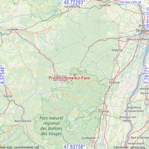
Provenchères-sur-Fave GPS coordinates[2]
48° 18' 26.64" North, 7° 4' 42.924" East
| Map corner | latitude | longitude |
|---|---|---|
| Upper-left | 48.77293°, | 6.37546° |
| Center: | 48.3074°, | 7.07859° |
| Lower-right: | 47.83758°, | 7.78171° |
| Map W x H: | 104×104 km | = 64.6×64.6mi |
| max Lat: | 51.07786° ⇑35.3% North |
| Provenchères-sur-Fave: | 48.3074° |
| min Lat: | ⇓64.7% South 41.3874° |
| min Long | Provenchères-s | max Long |
| -5.08615° | 7.07859° | 9.52242° |
| W 95.1%⇐ | ⇒4.9% E |
Elevation
Elevation of Provenchères-sur-Fave is 404 m = 1325 ft, and this is 210.3 m = 690 ft above average elevation for this country.
| Max E: |
2333 m = 7654 ft | 11.2% |
| Provenchères-sur-Fave | 404 m 1325 ft | |
| Avg. | 193.7 m = 635 ft | |
Min E: |
-1 m = -3 ft | 88.8% |
See also: France elevation on elevation.city.
Geographical zone
Provenchères-sur-Fave is located in North temperate zone (between Tropic of Cancer and the Arctic Circle). Distance of this North polar circle is 2029.9 km =1261.3 mi to North.| Distance of | km | miles | from Provenchères-sur-Fave |
|---|---|---|---|
| North Pole | 4635.8 | 2880.6 | to North |
| Arctic Circle | 2029.9 | 1261.3 | to North |
| Tropic Cancer | 2765.4 | 1718.3 | to South |
| Equator | 5371.3 | 3337.6 | to South |


Nearby cities:
15 places around Provenchères-sur-Fave: (largest is in red/bold)
• Ban-de-Laveline
7 km =4.3 mi,  187°
187°
• Colroy-la-Grande
2.5 km =1.6 mi,  66°
66°
• La Croix-aux-Mines
10 km =6.2 mi, 192°
• La Petite-Raon
12.5 km =7.8 mi,  330°
330°
• Mandray
11.6 km =7.2 mi,  212°
212°
• Nayemont-les-Fosses
5.4 km =3.4 mi,  257°
257°
• Plaine
13.2 km =8.2 mi,  22°
22°
• Saales
5.1 km =3.2 mi, 23°
• Saint-Dié-des-Vosges
9.9 km =6.2 mi,  254°
254°
• Sainte-Croix-aux-Mines
12.1 km =7.5 mi,  114°
114°
• Sainte-Marguerite
8.3 km =5.2 mi,  237°
237°
• Sainte-Marie-aux-Mines
10.3 km =6.4 mi,  131°
131°
• Saulcy-sur-Meurthe
11.5 km =7.1 mi,  227°
227°
• Senones
12.2 km =7.6 mi,  322°
322°
• Steige
13 km =8.1 mi,  62°
62°
Sources, notices
• [Note1] Compared only with cities in France existing in our database
• [Src1] Map data: © OpenStreetMap contributors (CC-BY-SA)
• [Src2] Other city data from geonames.org with taken over terms of usage.
• [Src3] Geographical zone / Annual Mean Temperature by Robert A. Rohde @ Wikipedia
