Saint-Denis-de-Cabanne geodata
Saint-Denis-de-Cabanne (Auvergne-Rhône-Alpes) is a populated place; located in France in Europe/Paris (GMT+2) time zone. With population of 1,323 people, there are 6928 cities with bigger population in this country. Compared to other cities in France, 64% of cities are located further ↑North; 69.8% of cities are located further ←West and 85.2% of cities have lower elevation than Saint-Denis-de-Cabanne. Note1
Administrative division(s):
- Level 1: Auvergne-Rhône-Alpes
- Level 2: Département de la Loire
- Level 3: Arrondissement de Roanne
- Level 4: Saint-Denis-de-Cabanne
Current local time in Saint-Denis-de-Cabanne:
01:14 PM, SaturdayDifference from your time zone: hours


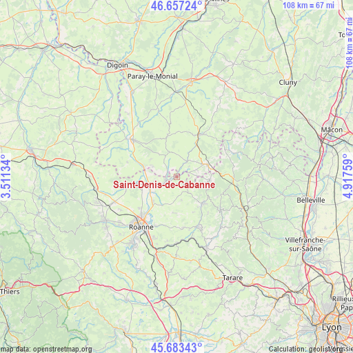
Saint-Denis-de-Cabanne GPS coordinates[2]
46° 10' 20.964" North, 4° 12' 52.092" East
| Map corner | latitude | longitude |
|---|---|---|
| Upper-left | 46.65724°, | 3.51134° |
| Center: | 46.17249°, | 4.21447° |
| Lower-right: | 45.68343°, | 4.91759° |
| Map W x H: | 108.3×108.3 km | = 67.3×67.3mi |
| max Lat: | 51.07786° ⇑64% North |
| Saint-Denis-de-Cabanne: | 46.17249° |
| min Lat: | ⇓36% South 41.3874° |
| min Long | Saint-Denis-de- | max Long |
| -5.08615° | 4.21447° | 9.52242° |
| W 69.8%⇐ | ⇒30.2% E |
Elevation
Elevation of Saint-Denis-de-Cabanne is 349 m = 1145 ft, and this is 155.3 m = 510 ft above average elevation for this country.
| Max E: |
2333 m = 7654 ft | 14.8% |
| Saint-Denis-de-Cabanne | 349 m 1145 ft | |
| Avg. | 193.7 m = 635 ft | |
Min E: |
-1 m = -3 ft | 85.2% |
See also: France elevation on elevation.city.
Geographical zone
Saint-Denis-de-Cabanne is located in North temperate zone (between Tropic of Cancer and the Arctic Circle). Distance of this North polar circle is 2267.3 km =1408.8 mi to North.| Distance of | km | miles | from Saint-Denis-de-Cabanne |
|---|---|---|---|
| North Pole | 4873.2 | 3028.1 | to North |
| Arctic Circle | 2267.3 | 1408.8 | to North |
| Tropic Cancer | 2528 | 1570.8 | to South |
| Equator | 5133.9 | 3190.1 | to South |


Nearby cities:
15 places around Saint-Denis-de-Cabanne: (largest is in red/bold)
• Belmont-de-la-Loire
10.3 km =6.4 mi,  94°
94°
• Chandon
2.6 km =1.6 mi,  180°
180°
• Charlieu
3.5 km =2.2 mi,  250°
250°
• Chassigny-sous-Dun
9.7 km =6 mi,  39°
39°
• Coublanc
4.5 km =2.8 mi, 86°
• Cuinzier
6.5 km =4 mi,  140°
140°
• Fleury-la-Montagne
8.2 km =5.1 mi,  296°
296°
• Le Cergne
9.3 km =5.8 mi,  127°
127°
• Mars
3.2 km =2 mi, 132°
• Nandax
9.1 km =5.7 mi,  204°
204°
• Pouilly-sous-Charlieu
8.4 km =5.2 mi, 249°
• Saint-Igny-de-Roche
6.5 km =4 mi,  68°
68°
• Saint-Maurice-lès-Châteauneuf
5.7 km =3.5 mi,  31°
31°
• Saint-Nizier-sous-Charlieu
7.3 km =4.5 mi, 252°
• Villers
5.7 km =3.5 mi,  174°
174°
Sources, notices
• [Note1] Compared only with cities in France existing in our database
• [Src1] Map data: © OpenStreetMap contributors (CC-BY-SA)
• [Src2] Other city data from geonames.org with taken over terms of usage.
• [Src3] Geographical zone / Annual Mean Temperature by Robert A. Rohde @ Wikipedia
