Saint-Cyr-sur-Menthon geodata
Saint-Cyr-sur-Menthon (Auvergne-Rhône-Alpes) is a populated place; located in France in Europe/Paris (GMT+2) time zone. With population of 1,452 people, there are 6369 cities with bigger population in this country. Compared to other cities in France, 62.6% of cities are located further ↑North; 77.4% of cities are located further ←West and 68% of cities have lower elevation than Saint-Cyr-sur-Menthon. Note1
Administrative division(s):
- Level 1: Auvergne-Rhône-Alpes
- Level 2: Département de l'Ain
- Level 3: Arrondissement de Bourg-en-Bresse
- Level 4: Saint-Cyr-sur-Menthon
Current local time in Saint-Cyr-sur-Menthon:
07:30 PM, SaturdayDifference from your time zone: hours


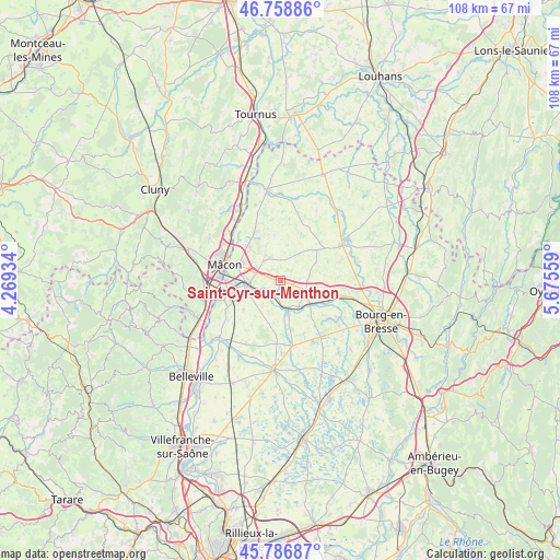
Saint-Cyr-sur-Menthon GPS coordinates[2]
46° 16' 30.072" North, 4° 58' 20.856" East
| Map corner | latitude | longitude |
|---|---|---|
| Upper-left | 46.75886°, | 4.26934° |
| Center: | 46.27502°, | 4.97246° |
| Lower-right: | 45.78687°, | 5.67559° |
| Map W x H: | 108.1×108.1 km | = 67.2×67.2mi |
| max Lat: | 51.07786° ⇑62.6% North |
| Saint-Cyr-sur-Menthon: | 46.27502° |
| min Lat: | ⇓37.4% South 41.3874° |
| min Long | Saint-Cyr-sur-M | max Long |
| -5.08615° | 4.97246° | 9.52242° |
| W 77.4%⇐ | ⇒22.6% E |
Elevation
Elevation of Saint-Cyr-sur-Menthon is 209 m = 686 ft, and this is 15.3 m = 50 ft above average elevation for this country.
| Max E: |
2333 m = 7654 ft | 32% |
| Saint-Cyr-sur-Menthon | 209 m 686 ft | |
| Avg. | 193.7 m = 635 ft | |
Min E: |
-1 m = -3 ft | 68% |
See also: France elevation on elevation.city.
Geographical zone
Saint-Cyr-sur-Menthon is located in North temperate zone (between Tropic of Cancer and the Arctic Circle). Distance of this North polar circle is 2255.9 km =1401.8 mi to North.| Distance of | km | miles | from Saint-Cyr-sur-Menthon |
|---|---|---|---|
| North Pole | 4861.8 | 3021 | to North |
| Arctic Circle | 2255.9 | 1401.8 | to North |
| Tropic Cancer | 2539.4 | 1577.9 | to South |
| Equator | 5145.3 | 3197.1 | to South |


Nearby cities:
15 places around Saint-Cyr-sur-Menthon: (largest is in red/bold)
• Biziat
6.8 km =4.2 mi,  199°
199°
• Bâgé-la-Ville
5.1 km =3.2 mi,  331°
331°
• Bâgé-le-Châtel
4.9 km =3 mi,  320°
320°
• Confrançon
7.3 km =4.5 mi,  97°
97°
• Crottet
6 km =3.7 mi,  271°
271°
• Curtafond
8.9 km =5.5 mi,  91°
91°
• Laiz
6.9 km =4.3 mi,  246°
246°
• Mézériat
7.1 km =4.4 mi,  126°
126°
• Perrex
3.3 km =2.1 mi,  173°
173°
• Pont-de-Veyle
6.8 km =4.2 mi,  257°
257°
• Replonges
7.4 km =4.6 mi,  292°
292°
• Saint-André-de-Bâgé
4.8 km =3 mi,  307°
307°
• Saint-Jean-sur-Veyle
4.6 km =2.9 mi, 247°
• Saint-Julien-sur-Veyle
8.4 km =5.2 mi,  188°
188°
• Vonnas
6.6 km =4.1 mi, 166°
Sources, notices
• [Note1] Compared only with cities in France existing in our database
• [Src1] Map data: © OpenStreetMap contributors (CC-BY-SA)
• [Src2] Other city data from geonames.org with taken over terms of usage.
• [Src3] Geographical zone / Annual Mean Temperature by Robert A. Rohde @ Wikipedia
