Saint-Côme-et-Maruéjols geodata
Saint-Côme-et-Maruéjols (Occitanie) is a populated place; located in France in Europe/Paris (GMT+2) time zone. With population of 622 people, there are 12950 cities with bigger population in this country. Compared to other cities in France, 88.9% of cities are located further ↑North; 69.7% of cities are located further ←West and 76.2% of cities have higher elevation than Saint-Côme-et-Maruéjols. Note1
Administrative division(s):
- Level 1: Occitanie
- Level 2: Gard
- Level 3: Arrondissement de Nîmes
- Level 4: Saint-Côme-et-Maruéjols
Current local time in Saint-Côme-et-Maruéjols:
01:38 PM, SundayDifference from your time zone: hours


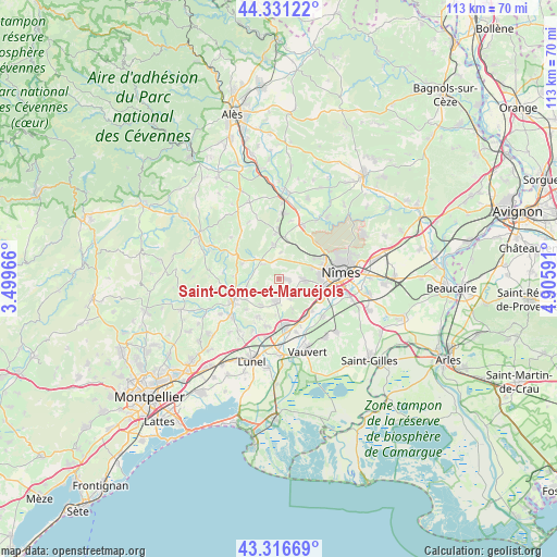
Saint-Côme-et-Maruéjols GPS coordinates[2]
43° 49' 33.996" North, 4° 12' 10.044" East
| Map corner | latitude | longitude |
|---|---|---|
| Upper-left | 44.33122°, | 3.49966° |
| Center: | 43.82611°, | 4.20279° |
| Lower-right: | 43.31669°, | 4.90591° |
| Map W x H: | 112.8×112.8 km | = 70.1×70.1mi |
| max Lat: | 51.07786° ⇑88.9% North |
| Saint-Côme-et-Maruéjols: | 43.82611° |
| min Lat: | ⇓11.1% South 41.3874° |
| min Long | Saint-Côme-et- | max Long |
| -5.08615° | 4.20279° | 9.52242° |
| W 69.7%⇐ | ⇒30.3% E |
Elevation
Elevation of Saint-Côme-et-Maruéjols is 64 m = 210 ft, and this is 129.7 m = 426 ft below average elevation for this country.
| Max E: |
2333 m = 7654 ft | 76.2% |
| Avg. | 193.7 m = 635 ft | |
| Saint-Côme-et-Maruéjols | 64 m = 210 ft | |
Min E: |
-1 m = -3 ft | 23.8% |
See also: France elevation on elevation.city.
Geographical zone
Saint-Côme-et-Maruéjols is located in North temperate zone (between Tropic of Cancer and the Arctic Circle). Distance of this Northern Tropic circle is 2267.1 km =1408.7 mi to South.| Distance of | km | miles | from Saint-Côme-et-Maruéjols |
|---|---|---|---|
| North Pole | 5134.1 | 3190.2 | to North |
| Arctic Circle | 2528.2 | 1571 | to North |
| Tropic Cancer | 2267.1 | 1408.7 | to South |
| Equator | 4873 | 3027.9 | to South |


Nearby cities:
15 places around Saint-Côme-et-Maruéjols: (largest is in red/bold)
• Aujargues
7.6 km =4.7 mi,  238°
238°
• Boissières
6.2 km =3.9 mi,  157°
157°
• Calvisson
4.4 km =2.7 mi,  186°
186°
• Caveirac
5.1 km =3.2 mi,  92°
92°
• Clarensac
1.4 km =0.9 mi, 93°
• Congénies
7.2 km =4.5 mi,  203°
203°
• Gajan
7.6 km =4.7 mi,  6°
6°
• Junas
8.9 km =5.5 mi,  227°
227°
• Langlade
4.7 km =2.9 mi,  123°
123°
• Montpezat
4.5 km =2.8 mi,  307°
307°
• Nages-et-Solorgues
4.6 km =2.9 mi,  151°
151°
• Parignargues
5.3 km =3.3 mi,  4°
4°
• Saint-Dionisy
3.8 km =2.4 mi,  139°
139°
• Saint-Mamert-du-Gard
7 km =4.3 mi,  349°
349°
• Souvignargues
6.6 km =4.1 mi,  256°
256°
Sources, notices
• [Note1] Compared only with cities in France existing in our database
• [Src1] Map data: © OpenStreetMap contributors (CC-BY-SA)
• [Src2] Other city data from geonames.org with taken over terms of usage.
• [Src3] Geographical zone / Annual Mean Temperature by Robert A. Rohde @ Wikipedia
