Aujargues geodata
Aujargues (Occitanie) is a populated place; located in France in Europe/Paris (GMT+2) time zone. With population of 784 people, there are 10781 cities with bigger population in this country. Compared to other cities in France, 89.2% of cities are located further ↑North; 69% of cities are located further ←West and 67.4% of cities have higher elevation than Aujargues. Note1
Administrative division(s):
- Level 1: Occitanie
- Level 2: Gard
- Level 3: Arrondissement de Nîmes
- Level 4: Aujargues


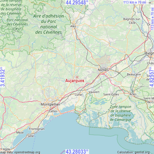
Aujargues GPS coordinates[2]
43° 47' 24.216" North, 4° 7' 20.82" East
| Map corner | latitude | longitude |
|---|---|---|
| Upper-left | 44.29548°, | 3.41932° |
| Center: | 43.79006°, | 4.12245° |
| Lower-right: | 43.28033°, | 4.82557° |
| Map W x H: | 112.9×112.9 km | = 70.2×70.2mi |
| max Lat: | 51.07786° ⇑89.2% North |
| Aujargues: | 43.79006° |
| min Lat: | ⇓10.8% South 41.3874° |
| min Long | Aujargues | max Long |
| -5.08615° | 4.12245° | 9.52242° |
| W 69%⇐ | ⇒31% E |
Elevation
Elevation of Aujargues is 84 m = 276 ft, and this is 109.7 m = 360 ft below average elevation for this country.
| Max E: |
2333 m = 7654 ft | 67.4% |
| Avg. | 193.7 m = 635 ft | |
| Aujargues | 84 m = 276 ft | |
Min E: |
-1 m = -3 ft | 32.6% |
See also: France elevation on elevation.city.
Geographical zone
Aujargues is located in North temperate zone (between Tropic of Cancer and the Arctic Circle). Distance of this Northern Tropic circle is 2263.1 km =1406.2 mi to South.| Distance of | km | miles | from Aujargues |
|---|---|---|---|
| North Pole | 5138.1 | 3192.7 | to North |
| Arctic Circle | 2532.2 | 1573.4 | to North |
| Tropic Cancer | 2263.1 | 1406.2 | to South |
| Equator | 4869 | 3025.5 | to South |


Nearby cities:
15 places around Aujargues: (largest is in red/bold)
• Aigues-Vives
7.4 km =4.6 mi,  141°
141°
• Aubais
4.4 km =2.7 mi,  155°
155°
• Boisseron
5 km =3.1 mi,  223°
223°
• Calvisson
5.9 km =3.7 mi,  93°
93°
• Congénies
4.4 km =2.7 mi,  126°
126°
• Junas
2.1 km =1.3 mi,  183°
183°
• Montpezat
7.4 km =4.6 mi,  22°
22°
• Saint-Côme-et-Maruéjols
7.6 km =4.7 mi,  58°
58°
• Saint-Sériès
6.6 km =4.1 mi,  195°
195°
• Saturargues
7.5 km =4.7 mi,  185°
185°
• Saussines
6.2 km =3.9 mi,  239°
239°
• Sommières
2.7 km =1.7 mi,  258°
258°
• Souvignargues
2.5 km =1.6 mi,  0°
0°
• Villetelle
6.7 km =4.2 mi,  170°
170°
• Villevieille
2 km =1.2 mi, 263°
Sources, notices
• [Note1] Compared only with cities in France existing in our database
• [Src1] Map data: © OpenStreetMap contributors (CC-BY-SA)
• [Src2] Other city data from geonames.org with taken over terms of usage.
• [Src3] Geographical zone / Annual Mean Temperature by Robert A. Rohde @ Wikipedia
