Gajan geodata
Gajan (Occitanie) is a populated place; located in France in Europe/Paris (GMT+2) time zone. With population of 684 people, there are 12023 cities with bigger population in this country. Compared to other cities in France, 88.1% of cities are located further ↑North; 69.8% of cities are located further ←West and 56.5% of cities have higher elevation than Gajan. Note1
Administrative division(s):
- Level 1: Occitanie
- Level 2: Gard
- Level 3: Arrondissement de Nîmes
- Level 4: Gajan


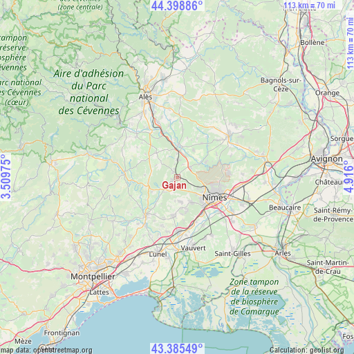
Gajan GPS coordinates[2]
43° 53' 39.588" North, 4° 12' 46.332" East
| Map corner | latitude | longitude |
|---|---|---|
| Upper-left | 44.39886°, | 3.50975° |
| Center: | 43.89433°, | 4.21287° |
| Lower-right: | 43.38549°, | 4.916° |
| Map W x H: | 112.7×112.7 km | = 70×70mi |
| max Lat: | 51.07786° ⇑88.1% North |
| Gajan: | 43.89433° |
| min Lat: | ⇓11.9% South 41.3874° |
| min Long | Gajan | max Long |
| -5.08615° | 4.21287° | 9.52242° |
| W 69.8%⇐ | ⇒30.2% E |
Elevation
Elevation of Gajan is 112 m = 367 ft, and this is 81.7 m = 268 ft below average elevation for this country.
| Max E: |
2333 m = 7654 ft | 56.5% |
| Avg. | 193.7 m = 635 ft | |
| Gajan | 112 m = 367 ft | |
Min E: |
-1 m = -3 ft | 43.5% |
See also: France elevation on elevation.city.
Geographical zone
Gajan is located in North temperate zone (between Tropic of Cancer and the Arctic Circle). Distance of this Northern Tropic circle is 2274.7 km =1413.4 mi to South.| Distance of | km | miles | from Gajan |
|---|---|---|---|
| North Pole | 5126.5 | 3185.5 | to North |
| Arctic Circle | 2520.6 | 1566.2 | to North |
| Tropic Cancer | 2274.7 | 1413.4 | to South |
| Equator | 4880.6 | 3032.7 | to South |


Nearby cities:
15 places around Gajan: (largest is in red/bold)
• Brignon
10.5 km =6.5 mi,  0°
0°
• Caveirac
8.9 km =5.5 mi,  151°
151°
• Clarensac
7.7 km =4.8 mi,  175°
175°
• Dions
7.9 km =4.9 mi,  58°
58°
• Domessargues
9.7 km =6 mi,  337°
337°
• La Calmette
5.3 km =3.3 mi,  53°
53°
• La Rouvière
4.4 km =2.7 mi,  22°
22°
• Montpezat
6.5 km =4 mi,  222°
222°
• Moussac
9.7 km =6 mi,  6°
6°
• Parignargues
2.4 km =1.5 mi,  189°
189°
• Saint-Chaptes
10.1 km =6.3 mi,  31°
31°
• Saint-Côme-et-Maruéjols
7.6 km =4.7 mi, 186°
• Saint-Geniès-de-Malgoirès
6.2 km =3.9 mi, 2°
• Saint-Mamert-du-Gard
2.2 km =1.4 mi,  252°
252°
• Sauzet
7.4 km =4.6 mi,  357°
357°
Sources, notices
• [Note1] Compared only with cities in France existing in our database
• [Src1] Map data: © OpenStreetMap contributors (CC-BY-SA)
• [Src2] Other city data from geonames.org with taken over terms of usage.
• [Src3] Geographical zone / Annual Mean Temperature by Robert A. Rohde @ Wikipedia
