Montpezat geodata
Montpezat (Occitanie) is a populated place; located in France in Europe/Paris (GMT+2) time zone. With population of 999 people, there are 8836 cities with bigger population in this country. Compared to other cities in France, 88.6% of cities are located further ↑North; 69.3% of cities are located further ←West and 54.7% of cities have lower elevation than Montpezat. Note1
Administrative division(s):
- Level 1: Occitanie
- Level 2: Gard
- Level 3: Arrondissement de Nîmes
- Level 4: Montpezat


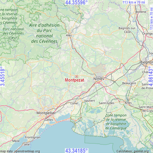
Montpezat GPS coordinates[2]
43° 51' 3.816" North, 4° 9' 29.88" East
| Map corner | latitude | longitude |
|---|---|---|
| Upper-left | 44.35596°, | 3.45518° |
| Center: | 43.85106°, | 4.1583° |
| Lower-right: | 43.34185°, | 4.86143° |
| Map W x H: | 112.8×112.8 km | = 70.1×70.1mi |
| max Lat: | 51.07786° ⇑88.6% North |
| Montpezat: | 43.85106° |
| min Lat: | ⇓11.4% South 41.3874° |
| min Long | Montpezat | max Long |
| -5.08615° | 4.1583° | 9.52242° |
| W 69.3%⇐ | ⇒30.7% E |
Elevation
Elevation of Montpezat is 149 m = 489 ft, and this is 44.7 m = 147 ft below average elevation for this country.
| Max E: |
2333 m = 7654 ft | 45.3% |
| Avg. | 193.7 m = 635 ft | |
| Montpezat | 149 m = 489 ft | |
Min E: |
-1 m = -3 ft | 54.7% |
See also: France elevation on elevation.city.
Geographical zone
Montpezat is located in North temperate zone (between Tropic of Cancer and the Arctic Circle). Distance of this Northern Tropic circle is 2269.9 km =1410.5 mi to South.| Distance of | km | miles | from Montpezat |
|---|---|---|---|
| North Pole | 5131.3 | 3188.4 | to North |
| Arctic Circle | 2525.4 | 1569.2 | to North |
| Tropic Cancer | 2269.9 | 1410.5 | to South |
| Equator | 4875.8 | 3029.7 | to South |


Nearby cities:
15 places around Montpezat: (largest is in red/bold)
• Aujargues
7.4 km =4.6 mi,  202°
202°
• Calvisson
7.8 km =4.8 mi,  156°
156°
• Caveirac
9.2 km =5.7 mi,  108°
108°
• Clarensac
5.7 km =3.5 mi,  119°
119°
• Gajan
6.5 km =4 mi,  42°
42°
• Junas
9.3 km =5.8 mi, 198°
• Langlade
9.3 km =5.8 mi,  125°
125°
• Nages-et-Solorgues
8.9 km =5.5 mi,  139°
139°
• Parignargues
4.7 km =2.9 mi,  58°
58°
• Saint-Côme-et-Maruéjols
4.5 km =2.8 mi, 127°
• Saint-Dionisy
8.3 km =5.2 mi, 133°
• Saint-Mamert-du-Gard
4.8 km =3 mi,  29°
29°
• Sommières
9.1 km =5.7 mi,  216°
216°
• Souvignargues
5.1 km =3.2 mi,  213°
213°
• Villevieille
8.5 km =5.3 mi, 214°
Sources, notices
• [Note1] Compared only with cities in France existing in our database
• [Src1] Map data: © OpenStreetMap contributors (CC-BY-SA)
• [Src2] Other city data from geonames.org with taken over terms of usage.
• [Src3] Geographical zone / Annual Mean Temperature by Robert A. Rohde @ Wikipedia
