Juvignac geodata
Juvignac (Occitanie) is a populated place; located in France in Europe/Paris (GMT+2) time zone. With population of 6,281 people, there are 1580 cities with bigger population in this country. Compared to other cities in France, 91.7% of cities are located further ↑North; 66.4% of cities are located further ←West and 80.2% of cities have higher elevation than Juvignac. Note1
Administrative division(s):
- Level 1: Occitanie
- Level 2: Département de l'Hérault
- Level 3: Arrondissement of Montpellier
- Level 4: Juvignac


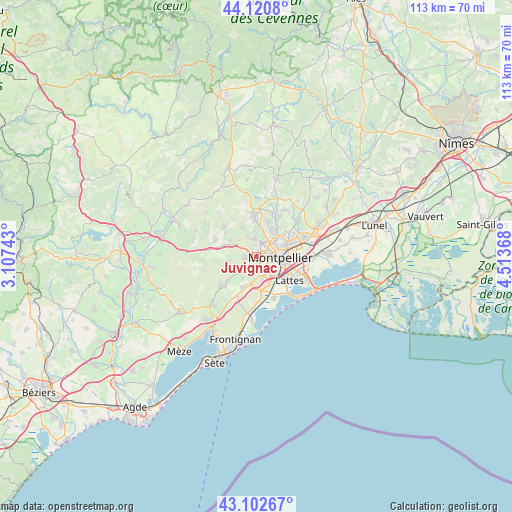
Juvignac GPS coordinates[2]
43° 36' 50.004" North, 3° 48' 38.016" East
| Map corner | latitude | longitude |
|---|---|---|
| Upper-left | 44.1208°, | 3.10743° |
| Center: | 43.61389°, | 3.81056° |
| Lower-right: | 43.10267°, | 4.51368° |
| Map W x H: | 113.2×113.2 km | = 70.3×70.3mi |
| max Lat: | 51.07786° ⇑91.7% North |
| Juvignac: | 43.61389° |
| min Lat: | ⇓8.3% South 41.3874° |
| min Long | Juvignac | max Long |
| -5.08615° | 3.81056° | 9.52242° |
| W 66.4%⇐ | ⇒33.6% E |
Elevation
Elevation of Juvignac is 54 m = 177 ft, and this is 139.7 m = 458 ft below average elevation for this country.
| Max E: |
2333 m = 7654 ft | 80.2% |
| Avg. | 193.7 m = 635 ft | |
| Juvignac | 54 m = 177 ft | |
Min E: |
-1 m = -3 ft | 19.8% |
See also: France elevation on elevation.city.
Geographical zone
Juvignac is located in North temperate zone (between Tropic of Cancer and the Arctic Circle). Distance of this Northern Tropic circle is 2243.5 km =1394 mi to South.| Distance of | km | miles | from Juvignac |
|---|---|---|---|
| North Pole | 5157.7 | 3204.8 | to North |
| Arctic Circle | 2551.8 | 1585.6 | to North |
| Tropic Cancer | 2243.5 | 1394 | to South |
| Equator | 4849.4 | 3013.3 | to South |


Nearby cities:
15 places around Juvignac: (largest is in red/bold)
• Castelnau-le-Lez
7.5 km =4.7 mi,  73°
73°
• Clapiers
8 km =5 mi,  52°
52°
• Combaillaux
7.3 km =4.5 mi,  331°
331°
• Fabrègues
7.6 km =4.7 mi,  201°
201°
• Grabels
3.9 km =2.4 mi,  345°
345°
• Lattes
9.2 km =5.7 mi,  124°
124°
• Lavérune
3.1 km =1.9 mi,  186°
186°
• Montferrier-sur-Lez
6.9 km =4.3 mi,  30°
30°
• Montpellier
5.4 km =3.4 mi,  93°
93°
• Murviel-lès-Montpellier
6 km =3.7 mi,  260°
260°
• Pignan
5.3 km =3.3 mi,  230°
230°
• Saint-Clément-de-Rivière
7.9 km =4.9 mi,  13°
13°
• Saint-Gély-du-Fesc
8.8 km =5.5 mi,  357°
357°
• Saint-Jean-de-Védas
4.2 km =2.6 mi,  162°
162°
• Saussan
5.4 km =3.4 mi,  211°
211°
Sources, notices
• [Note1] Compared only with cities in France existing in our database
• [Src1] Map data: © OpenStreetMap contributors (CC-BY-SA)
• [Src2] Other city data from geonames.org with taken over terms of usage.
• [Src3] Geographical zone / Annual Mean Temperature by Robert A. Rohde @ Wikipedia
