Saint-Bardoux geodata
Saint-Bardoux (Auvergne-Rhône-Alpes) is a populated place; located in France in Europe/Paris (GMT+2) time zone. With population of 584 people, there are 13570 cities with bigger population in this country. Compared to other cities in France, 78.7% of cities are located further ↑North; 77.4% of cities are located further ←West and 75.8% of cities have lower elevation than Saint-Bardoux. Note1
Administrative division(s):
- Level 1: Auvergne-Rhône-Alpes
- Level 2: Département de la Drôme
- Level 3: Arrondissement de Valence
- Level 4: Saint-Bardoux


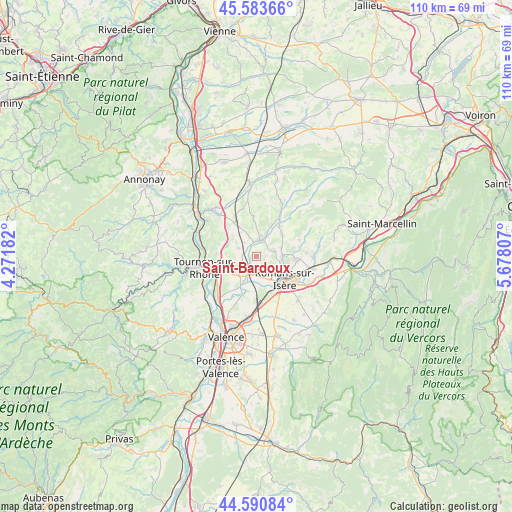
Saint-Bardoux GPS coordinates[2]
45° 5' 21.876" North, 4° 58' 29.784" East
| Map corner | latitude | longitude |
|---|---|---|
| Upper-left | 45.58366°, | 4.27182° |
| Center: | 45.08941°, | 4.97494° |
| Lower-right: | 44.59084°, | 5.67807° |
| Map W x H: | 110.4×110.4 km | = 68.6×68.6mi |
| max Lat: | 51.07786° ⇑78.7% North |
| Saint-Bardoux: | 45.08941° |
| min Lat: | ⇓21.3% South 41.3874° |
| min Long | Saint-Bardoux | max Long |
| -5.08615° | 4.97494° | 9.52242° |
| W 77.4%⇐ | ⇒22.6% E |
Elevation
Elevation of Saint-Bardoux is 255 m = 837 ft, and this is 61.3 m = 201 ft above average elevation for this country.
| Max E: |
2333 m = 7654 ft | 24.2% |
| Saint-Bardoux | 255 m 837 ft | |
| Avg. | 193.7 m = 635 ft | |
Min E: |
-1 m = -3 ft | 75.8% |
See also: France elevation on elevation.city.
Geographical zone
Saint-Bardoux is located in North temperate zone (between Tropic of Cancer and the Arctic Circle). Distance of this North polar circle is 2387.7 km =1483.6 mi to North.| Distance of | km | miles | from Saint-Bardoux |
|---|---|---|---|
| North Pole | 4993.6 | 3102.9 | to North |
| Arctic Circle | 2387.7 | 1483.6 | to North |
| Tropic Cancer | 2407.6 | 1496 | to South |
| Equator | 5013.5 | 3115.2 | to South |


Nearby cities:
15 places around Saint-Bardoux: (largest is in red/bold)
• Beaumont-Monteux
8.9 km =5.5 mi,  209°
209°
• Bourg-de-Péage
8.7 km =5.4 mi,  137°
137°
• Bren
5.8 km =3.6 mi,  337°
337°
• Chanos-Curson
5.1 km =3.2 mi,  231°
231°
• Chantemerle-les-Blés
6.9 km =4.3 mi,  295°
295°
• Châteauneuf-sur-Isère
8.7 km =5.4 mi,  202°
202°
• Clérieux
1.9 km =1.2 mi,  218°
218°
• Génissieux
8.4 km =5.2 mi,  94°
94°
• Larnage
8.8 km =5.5 mi,  275°
275°
• Margès
8.1 km =5 mi,  38°
38°
• Mercurol-Veaunes
6.7 km =4.2 mi,  255°
255°
• Mours-Saint-Eusèbe
7 km =4.3 mi,  112°
112°
• Peyrins
5.5 km =3.4 mi, 85°
• Romans-sur-Isère
8.4 km =5.2 mi,  121°
121°
• Tain-l’Hermitage
9.7 km =6 mi,  254°
254°
Sources, notices
• [Note1] Compared only with cities in France existing in our database
• [Src1] Map data: © OpenStreetMap contributors (CC-BY-SA)
• [Src2] Other city data from geonames.org with taken over terms of usage.
• [Src3] Geographical zone / Annual Mean Temperature by Robert A. Rohde @ Wikipedia
