Mercurol-Veaunes geodata
Mercurol-Veaunes (Auvergne-Rhône-Alpes) is a populated place; located in France in Europe/Paris (GMT+2) time zone. With population of 1,809 people, there are 5243 cities with bigger population in this country. Compared to other cities in France, 78.8% of cities are located further ↑North; 76.4% of cities are located further ←West and 64.6% of cities have lower elevation than Mercurol-Veaunes. Note1
Administrative division(s):
- Level 1: Auvergne-Rhône-Alpes
- Level 2: Département de la Drôme
- Level 3: Arrondissement de Valence
- Level 4: Mercurol-Veaunes


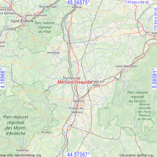
Mercurol-Veaunes GPS coordinates[2]
45° 4' 27.732" North, 4° 53' 34.044" East
| Map corner | latitude | longitude |
|---|---|---|
| Upper-left | 45.56875°, | 4.18966° |
| Center: | 45.07437°, | 4.89279° |
| Lower-right: | 44.57567°, | 5.59591° |
| Map W x H: | 110.4×110.4 km | = 68.6×68.6mi |
| max Lat: | 51.07786° ⇑78.8% North |
| Mercurol-Veaunes: | 45.07437° |
| min Lat: | ⇓21.2% South 41.3874° |
| min Long | Mercurol-Veaune | max Long |
| -5.08615° | 4.89279° | 9.52242° |
| W 76.4%⇐ | ⇒23.6% E |
Elevation
Elevation of Mercurol-Veaunes is 192 m = 630 ft, and this is 1.7 m = 6 ft below average elevation for this country.
| Max E: |
2333 m = 7654 ft | 35.4% |
| Avg. | 193.7 m = 635 ft | |
| Mercurol-Veaunes | 192 m = 630 ft | |
Min E: |
-1 m = -3 ft | 64.6% |
See also: France elevation on elevation.city.
Geographical zone
Mercurol-Veaunes is located in North temperate zone (between Tropic of Cancer and the Arctic Circle). Distance of this North polar circle is 2389.4 km =1484.7 mi to North.| Distance of | km | miles | from Mercurol-Veaunes |
|---|---|---|---|
| North Pole | 4995.3 | 3103.9 | to North |
| Arctic Circle | 2389.4 | 1484.7 | to North |
| Tropic Cancer | 2405.9 | 1495 | to South |
| Equator | 5011.8 | 3114.2 | to South |


Nearby cities:
15 places around Mercurol-Veaunes: (largest is in red/bold)
• Beaumont-Monteux
6.4 km =4 mi,  161°
161°
• Chanos-Curson
2.9 km =1.8 mi,  122°
122°
• Chantemerle-les-Blés
4.6 km =2.9 mi,  3°
3°
• Châteauneuf-sur-Isère
7.2 km =4.5 mi,  153°
153°
• Clérieux
5.3 km =3.3 mi,  88°
88°
• Glun
7.8 km =4.8 mi,  213°
213°
• La Roche-de-Glun
7.8 km =4.8 mi, 209°
• Larnage
3.4 km =2.1 mi,  317°
317°
• Mauves
6.4 km =4 mi,  231°
231°
• Saint-Bardoux
6.7 km =4.2 mi,  75°
75°
• Saint-Jean-de-Muzols
6.2 km =3.9 mi,  277°
277°
• Tain-l’Hermitage
3 km =1.9 mi,  253°
253°
• Tournon-sur-Rhône
4.7 km =2.9 mi,  259°
259°
• Vion
7.8 km =4.8 mi,  300°
300°
• Érôme
7.7 km =4.8 mi,  312°
312°
Sources, notices
• [Note1] Compared only with cities in France existing in our database
• [Src1] Map data: © OpenStreetMap contributors (CC-BY-SA)
• [Src2] Other city data from geonames.org with taken over terms of usage.
• [Src3] Geographical zone / Annual Mean Temperature by Robert A. Rohde @ Wikipedia
