Chanos-Curson geodata
Chanos-Curson (Auvergne-Rhône-Alpes) is a populated place; located in France in Europe/Paris (GMT+2) time zone. With population of 1,018 people, there are 8707 cities with bigger population in this country. Compared to other cities in France, 79% of cities are located further ↑North; 76.8% of cities are located further ←West and 70.6% of cities have lower elevation than Chanos-Curson. Note1
Administrative division(s):
- Level 1: Auvergne-Rhône-Alpes
- Level 2: Département de la Drôme
- Level 3: Arrondissement de Valence
- Level 4: Chanos-Curson


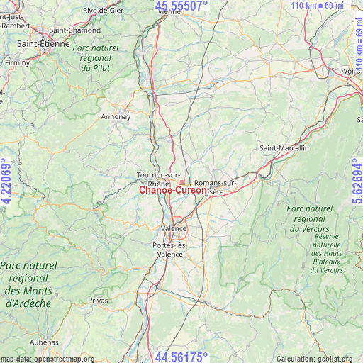
Chanos-Curson GPS coordinates[2]
45° 3' 38.052" North, 4° 55' 25.716" East
| Map corner | latitude | longitude |
|---|---|---|
| Upper-left | 45.55507°, | 4.22069° |
| Center: | 45.06057°, | 4.92381° |
| Lower-right: | 44.56175°, | 5.62694° |
| Map W x H: | 110.4×110.4 km | = 68.6×68.6mi |
| max Lat: | 51.07786° ⇑79% North |
| Chanos-Curson: | 45.06057° |
| min Lat: | ⇓21% South 41.3874° |
| min Long | Chanos-Curson | max Long |
| -5.08615° | 4.92381° | 9.52242° |
| W 76.8%⇐ | ⇒23.2% E |
Elevation
Elevation of Chanos-Curson is 222 m = 728 ft, and this is 28.3 m = 93 ft above average elevation for this country.
| Max E: |
2333 m = 7654 ft | 29.4% |
| Chanos-Curson | 222 m 728 ft | |
| Avg. | 193.7 m = 635 ft | |
Min E: |
-1 m = -3 ft | 70.6% |
See also: France elevation on elevation.city.
Geographical zone
Chanos-Curson is located in North temperate zone (between Tropic of Cancer and the Arctic Circle). Distance of this North polar circle is 2390.9 km =1485.6 mi to North.| Distance of | km | miles | from Chanos-Curson |
|---|---|---|---|
| North Pole | 4996.8 | 3104.9 | to North |
| Arctic Circle | 2390.9 | 1485.6 | to North |
| Tropic Cancer | 2404.3 | 1494 | to South |
| Equator | 5010.3 | 3113.3 | to South |


Nearby cities:
15 places around Chanos-Curson: (largest is in red/bold)
• Beaumont-Monteux
4.6 km =2.9 mi,  184°
184°
• Bren
8.7 km =5.4 mi,  11°
11°
• Chantemerle-les-Blés
6.5 km =4 mi,  340°
340°
• Châteauneuf-sur-Isère
4.9 km =3 mi,  171°
171°
• Clérieux
3.3 km =2.1 mi,  58°
58°
• Glun
8.3 km =5.2 mi,  233°
233°
• La Roche-de-Glun
8.1 km =5 mi, 229°
• Larnage
6.2 km =3.9 mi,  310°
310°
• Mauves
7.8 km =4.8 mi,  251°
251°
• Mercurol-Veaunes
2.9 km =1.8 mi,  302°
302°
• Peyrins
10.2 km =6.3 mi,  69°
69°
• Saint-Bardoux
5.1 km =3.2 mi,  51°
51°
• Saint-Jean-de-Muzols
8.9 km =5.5 mi,  285°
285°
• Tain-l’Hermitage
5.4 km =3.4 mi,  277°
277°
• Tournon-sur-Rhône
7.1 km =4.4 mi, 275°
Sources, notices
• [Note1] Compared only with cities in France existing in our database
• [Src1] Map data: © OpenStreetMap contributors (CC-BY-SA)
• [Src2] Other city data from geonames.org with taken over terms of usage.
• [Src3] Geographical zone / Annual Mean Temperature by Robert A. Rohde @ Wikipedia
