Saint-Astier geodata
Saint-Astier (Nouvelle-Aquitaine) is a populated place; located in France in Europe/Paris (GMT+2) time zone. With population of 4,914 people, there are 2015 cities with bigger population in this country. Compared to other cities in France, 78% of cities are located further ↑North; 73.2% of cities are located further →East and 69.2% of cities have higher elevation than Saint-Astier. Note1
Administrative division(s):
- Level 1: Nouvelle-Aquitaine
- Level 2: Dordogne
- Level 3: Arrondissement de Périgueux
- Level 4: Saint-Astier


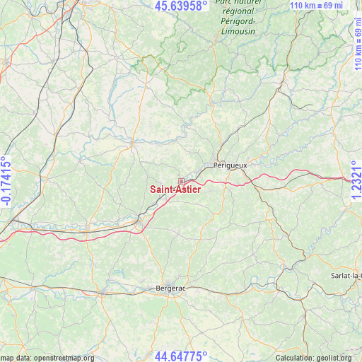
Saint-Astier GPS coordinates[2]
45° 8' 44.952" North, 0° 31' 44.328" East
| Map corner | latitude | longitude |
|---|---|---|
| Upper-left | 45.63958°, | -0.17415° |
| Center: | 45.14582°, | 0.52898° |
| Lower-right: | 44.64775°, | 1.2321° |
| Map W x H: | 110.3×110.3 km | = 68.5×68.5mi |
| max Lat: | 51.07786° ⇑78% North |
| Saint-Astier: | 45.14582° |
| min Lat: | ⇓22% South 41.3874° |
| min Long | Saint-Astier | max Long |
| -5.08615° | 0.52898° | 9.52242° |
| W 26.8%⇐ | ⇒73.2% E |
Elevation
Elevation of Saint-Astier is 80 m = 262 ft, and this is 113.7 m = 373 ft below average elevation for this country.
| Max E: |
2333 m = 7654 ft | 69.2% |
| Avg. | 193.7 m = 635 ft | |
| Saint-Astier | 80 m = 262 ft | |
Min E: |
-1 m = -3 ft | 30.8% |
See also: France elevation on elevation.city.
Geographical zone
Saint-Astier is located in North temperate zone (between Tropic of Cancer and the Arctic Circle). Distance of this North polar circle is 2381.4 km =1479.7 mi to North.| Distance of | km | miles | from Saint-Astier |
|---|---|---|---|
| North Pole | 4987.3 | 3099 | to North |
| Arctic Circle | 2381.4 | 1479.7 | to North |
| Tropic Cancer | 2413.8 | 1499.9 | to South |
| Equator | 5019.7 | 3119.1 | to South |


Nearby cities:
15 places around Saint-Astier: (largest is in red/bold)
• Annesse-et-Beaulieu
3.9 km =2.4 mi,  58°
58°
• Coulounieix-Chamiers
12.5 km =7.8 mi,  86°
86°
• Coursac
8.8 km =5.5 mi,  102°
102°
• Douzillac
11.2 km =7 mi,  232°
232°
• Grignols
7.1 km =4.4 mi,  173°
173°
• La Chapelle-Gonaguet
11.5 km =7.1 mi,  33°
33°
• Manzac-sur-Vern
7.9 km =4.9 mi,  145°
145°
• Mensignac
9.2 km =5.7 mi,  16°
16°
• Montrem
5 km =3.1 mi,  105°
105°
• Neuvic
6.9 km =4.3 mi,  222°
222°
• Razac-sur-l’Isle
6 km =3.7 mi,  70°
70°
• Saint-Germain-du-Salembre
6.2 km =3.9 mi,  262°
262°
• Saint-Léon-sur-l’Isle
3.9 km =2.4 mi,  209°
209°
• Saint-Vincent-de-Connezac
10.5 km =6.5 mi,  281°
281°
• Tocane-Saint-Apre
12.3 km =7.6 mi,  348°
348°
Sources, notices
• [Note1] Compared only with cities in France existing in our database
• [Src1] Map data: © OpenStreetMap contributors (CC-BY-SA)
• [Src2] Other city data from geonames.org with taken over terms of usage.
• [Src3] Geographical zone / Annual Mean Temperature by Robert A. Rohde @ Wikipedia
