Annesse-et-Beaulieu geodata
Annesse-et-Beaulieu (Nouvelle-Aquitaine) is a populated place; located in France in Europe/Paris (GMT+2) time zone. With population of 1,349 people, there are 6819 cities with bigger population in this country. Compared to other cities in France, 77.8% of cities are located further ↑North; 72.7% of cities are located further →East and 72.3% of cities have higher elevation than Annesse-et-Beaulieu. Note1
Administrative division(s):
- Level 1: Nouvelle-Aquitaine
- Level 2: Dordogne
- Level 3: Arrondissement de Périgueux
- Level 4: Annesse-et-Beaulieu


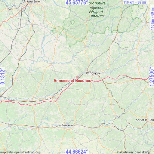
Annesse-et-Beaulieu GPS coordinates[2]
45° 9' 50.976" North, 0° 34' 18.948" East
| Map corner | latitude | longitude |
|---|---|---|
| Upper-left | 45.65776°, | -0.1312° |
| Center: | 45.16416°, | 0.57193° |
| Lower-right: | 44.66624°, | 1.27505° |
| Map W x H: | 110.2×110.2 km | = 68.5×68.5mi |
| max Lat: | 51.07786° ⇑77.8% North |
| Annesse-et-Beaulieu: | 45.16416° |
| min Lat: | ⇓22.2% South 41.3874° |
| min Long | Annesse-et-Beau | max Long |
| -5.08615° | 0.57193° | 9.52242° |
| W 27.3%⇐ | ⇒72.7% E |
Elevation
Elevation of Annesse-et-Beaulieu is 73 m = 240 ft, and this is 120.7 m = 396 ft below average elevation for this country.
| Max E: |
2333 m = 7654 ft | 72.3% |
| Avg. | 193.7 m = 635 ft | |
| Annesse-et-Beaulieu | 73 m = 240 ft | |
Min E: |
-1 m = -3 ft | 27.7% |
See also: France elevation on elevation.city.
Geographical zone
Annesse-et-Beaulieu is located in North temperate zone (between Tropic of Cancer and the Arctic Circle). Distance of this North polar circle is 2379.4 km =1478.5 mi to North.| Distance of | km | miles | from Annesse-et-Beaulieu |
|---|---|---|---|
| North Pole | 4985.3 | 3097.7 | to North |
| Arctic Circle | 2379.4 | 1478.5 | to North |
| Tropic Cancer | 2415.9 | 1501.2 | to South |
| Equator | 5021.8 | 3120.4 | to South |


Nearby cities:
15 places around Annesse-et-Beaulieu: (largest is in red/bold)
• Chancelade
8.9 km =5.5 mi,  62°
62°
• Coulounieix-Chamiers
9.2 km =5.7 mi,  97°
97°
• Coursac
6.6 km =4.1 mi,  126°
126°
• Grignols
9.4 km =5.8 mi,  195°
195°
• La Chapelle-Gonaguet
8.1 km =5 mi,  22°
22°
• Manzac-sur-Vern
8.6 km =5.3 mi,  172°
172°
• Mensignac
6.8 km =4.2 mi,  353°
353°
• Montrem
3.6 km =2.2 mi,  156°
156°
• Neuvic
10.7 km =6.6 mi,  228°
228°
• Périgueux
11.5 km =7.1 mi,  79°
79°
• Razac-sur-l’Isle
2.3 km =1.4 mi,  92°
92°
• Saint-Astier
3.9 km =2.4 mi,  238°
238°
• Saint-Germain-du-Salembre
10 km =6.2 mi,  253°
253°
• Saint-Léon-sur-l’Isle
7.6 km =4.7 mi,  224°
224°
• Tocane-Saint-Apre
11.6 km =7.2 mi,  329°
329°
Sources, notices
• [Note1] Compared only with cities in France existing in our database
• [Src1] Map data: © OpenStreetMap contributors (CC-BY-SA)
• [Src2] Other city data from geonames.org with taken over terms of usage.
• [Src3] Geographical zone / Annual Mean Temperature by Robert A. Rohde @ Wikipedia
