Saint-André-sur-Orne geodata
Saint-André-sur-Orne (Normandy) is a populated place; located in France in Europe/Paris (GMT+2) time zone. With population of 1,679 people, there are 5581 cities with bigger population in this country. Compared to other cities in France, 82.6% of cities are located further ↓South; 81.8% of cities are located further →East and 88.3% of cities have higher elevation than Saint-André-sur-Orne. Note1
Administrative division(s):
- Level 1: Normandy
- Level 2: Calvados
- Level 3: Arrondissement de Caen
- Level 4: Saint-André-sur-Orne


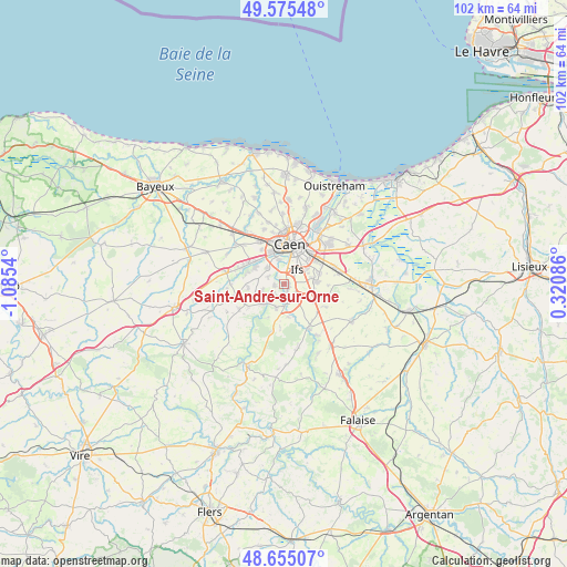
Saint-André-sur-Orne GPS coordinates[2]
49° 7' 2.676" North, 0° 22' 56.172" West
| Map corner | latitude | longitude |
|---|---|---|
| Upper-left | 49.57548°, | -1.0854° |
| Center: | 49.11741°, | -0.38227° |
| Lower-right: | 48.65507°, | 0.32086° |
| Map W x H: | 102.3×102.3 km | = 63.6×63.6mi |
| max Lat: | 51.07786° ⇑17.4% North |
| Saint-André-sur-Orne: | 49.11741° |
| min Lat: | ⇓82.6% South 41.3874° |
| min Long | Saint-André-su | max Long |
| -5.08615° | -0.38227° | 9.52242° |
| W 18.2%⇐ | ⇒81.8% E |
Elevation
Elevation of Saint-André-sur-Orne is 34 m = 112 ft, and this is 159.7 m = 524 ft below average elevation for this country.
| Max E: |
2333 m = 7654 ft | 88.3% |
| Avg. | 193.7 m = 635 ft | |
| Saint-André-sur-Orne | 34 m = 112 ft | |
Min E: |
-1 m = -3 ft | 11.7% |
See also: France elevation on elevation.city.
Geographical zone
Saint-André-sur-Orne is located in North temperate zone (between Tropic of Cancer and the Arctic Circle). Distance of this North polar circle is 1939.8 km =1205.3 mi to North.| Distance of | km | miles | from Saint-André-sur-Orne |
|---|---|---|---|
| North Pole | 4545.7 | 2824.6 | to North |
| Arctic Circle | 1939.8 | 1205.3 | to North |
| Tropic Cancer | 2855.4 | 1774.3 | to South |
| Equator | 5461.3 | 3393.5 | to South |


Nearby cities:
15 places around Saint-André-sur-Orne: (largest is in red/bold)
• Amayé-sur-Orne
5.4 km =3.4 mi,  229°
229°
• Bretteville-sur-Odon
6 km =3.7 mi,  335°
335°
• Bully
2.6 km =1.6 mi, 226°
• Clinchamps-sur-Orne
4.5 km =2.8 mi,  198°
198°
• Cormelles-le-Royal
5.5 km =3.4 mi,  42°
42°
• Fleury-sur-Orne
3.5 km =2.2 mi,  8°
8°
• Fontenay-le-Marmion
3.4 km =2.1 mi,  141°
141°
• Ifs
3.5 km =2.2 mi, 43°
• Louvigny
4.5 km =2.8 mi,  349°
349°
• Maltot
3.2 km =2 mi,  291°
291°
• May-sur-Orne
1.9 km =1.2 mi,  163°
163°
• Rocquancourt
5.1 km =3.2 mi,  120°
120°
• Saint-Martin-de-Fontenay
0.7 km =0.4 mi,  111°
111°
• Vieux
3.9 km =2.4 mi,  253°
253°
• Éterville
4.3 km =2.7 mi,  313°
313°
Sources, notices
• [Note1] Compared only with cities in France existing in our database
• [Src1] Map data: © OpenStreetMap contributors (CC-BY-SA)
• [Src2] Other city data from geonames.org with taken over terms of usage.
• [Src3] Geographical zone / Annual Mean Temperature by Robert A. Rohde @ Wikipedia
