Saint-André-de-Boëge geodata
Saint-André-de-Boëge (Auvergne-Rhône-Alpes) is a populated place; located in France in Europe/Paris (GMT+2) time zone. With population of 569 people, there are 13839 cities with bigger population in this country. Compared to other cities in France, 63.7% of cities are located further ↑North; 91% of cities are located further ←West and 98.3% of cities have lower elevation than Saint-André-de-Boëge. Note1
Administrative division(s):
- Level 1: Auvergne-Rhône-Alpes
- Level 2: Haute-Savoie
- Level 3: Arrondissement de Thonon-les-Bains
- Level 4: Saint-André-de-Boëge


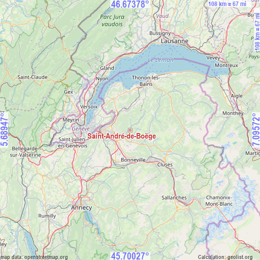
Saint-André-de-Boëge GPS coordinates[2]
46° 11' 21.048" North, 6° 23' 33.324" East
| Map corner | latitude | longitude |
|---|---|---|
| Upper-left | 46.67378°, | 5.68947° |
| Center: | 46.18918°, | 6.39259° |
| Lower-right: | 45.70027°, | 7.09572° |
| Map W x H: | 108.2×108.2 km | = 67.2×67.2mi |
| max Lat: | 51.07786° ⇑63.7% North |
| Saint-André-de-Boëge: | 46.18918° |
| min Lat: | ⇓36.3% South 41.3874° |
| min Long | Saint-André-de | max Long |
| -5.08615° | 6.39259° | 9.52242° |
| W 91%⇐ | ⇒9% E |
Elevation
Elevation of Saint-André-de-Boëge is 858 m = 2815 ft, and this is 664.3 m = 2179 ft above average elevation for this country.
| Max E: |
2333 m = 7654 ft | 1.7% |
| Saint-André-de-Boëge | 858 m 2815 ft | |
| Avg. | 193.7 m = 635 ft | |
Min E: |
-1 m = -3 ft | 98.3% |
See also: France elevation on elevation.city.
Geographical zone
Saint-André-de-Boëge is located in North temperate zone (between Tropic of Cancer and the Arctic Circle). Distance of this North polar circle is 2265.4 km =1407.7 mi to North.| Distance of | km | miles | from Saint-André-de-Boëge |
|---|---|---|---|
| North Pole | 4871.3 | 3026.9 | to North |
| Arctic Circle | 2265.4 | 1407.7 | to North |
| Tropic Cancer | 2529.8 | 1571.9 | to South |
| Equator | 5135.8 | 3191.2 | to South |


Nearby cities:
15 places around Saint-André-de-Boëge: (largest is in red/bold)
• Bogève
2.2 km =1.4 mi,  78°
78°
• Bonne
5.6 km =3.5 mi,  250°
250°
• Boëge
2.2 km =1.4 mi,  24°
24°
• Burdignin
4.3 km =2.7 mi,  33°
33°
• Contamine-sur-Arve
7 km =4.3 mi,  221°
221°
• Cranves-Sales
7.2 km =4.5 mi,  268°
268°
• Fillinges
5.1 km =3.2 mi,  229°
229°
• Habère-Lullin
7 km =4.3 mi,  43°
43°
• La Tour
6.9 km =4.3 mi,  154°
154°
• Lucinges
6 km =3.7 mi, 272°
• Marcellaz
5.5 km =3.4 mi,  211°
211°
• Onnion
6.8 km =4.2 mi,  105°
105°
• Peillonnex
6.8 km =4.2 mi,  190°
190°
• Ville-en-Sallaz
5.4 km =3.4 mi,  155°
155°
• Viuz-en-Sallaz
4.9 km =3 mi,  166°
166°
Sources, notices
• [Note1] Compared only with cities in France existing in our database
• [Src1] Map data: © OpenStreetMap contributors (CC-BY-SA)
• [Src2] Other city data from geonames.org with taken over terms of usage.
• [Src3] Geographical zone / Annual Mean Temperature by Robert A. Rohde @ Wikipedia
