Onnion geodata
Onnion (Auvergne-Rhône-Alpes) is a populated place; located in France in Europe/Paris (GMT+2) time zone. With population of 862 people, there are 9979 cities with bigger population in this country. Compared to other cities in France, 64% of cities are located further ↑North; 91.6% of cities are located further ←West and 97.4% of cities have lower elevation than Onnion. Note1
Administrative division(s):
- Level 1: Auvergne-Rhône-Alpes
- Level 2: Haute-Savoie
- Level 3: Arrondissement de Bonneville
- Level 4: Onnion


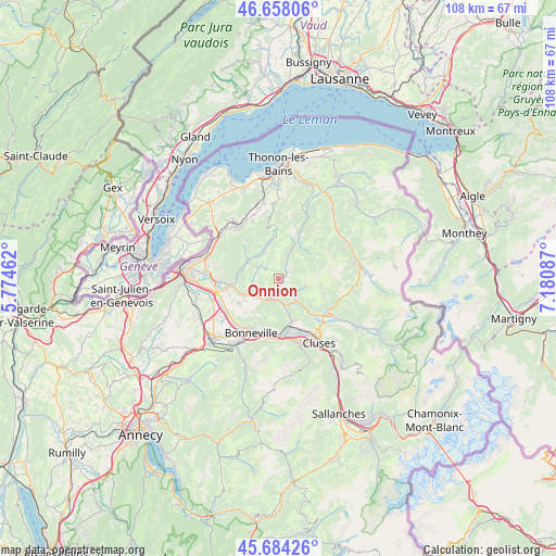
Onnion GPS coordinates[2]
46° 10' 23.952" North, 6° 28' 39.864" East
| Map corner | latitude | longitude |
|---|---|---|
| Upper-left | 46.65806°, | 5.77462° |
| Center: | 46.17332°, | 6.47774° |
| Lower-right: | 45.68426°, | 7.18087° |
| Map W x H: | 108.3×108.3 km | = 67.3×67.3mi |
| max Lat: | 51.07786° ⇑64% North |
| Onnion: | 46.17332° |
| min Lat: | ⇓36% South 41.3874° |
| min Long | Onnion | max Long |
| -5.08615° | 6.47774° | 9.52242° |
| W 91.6%⇐ | ⇒8.4% E |
Elevation
Elevation of Onnion is 759 m = 2490 ft, and this is 565.3 m = 1855 ft above average elevation for this country.
| Max E: |
2333 m = 7654 ft | 2.6% |
| Onnion | 759 m 2490 ft | |
| Avg. | 193.7 m = 635 ft | |
Min E: |
-1 m = -3 ft | 97.4% |
See also: France elevation on elevation.city.
Geographical zone
Onnion is located in North temperate zone (between Tropic of Cancer and the Arctic Circle). Distance of this North polar circle is 2267.2 km =1408.8 mi to North.| Distance of | km | miles | from Onnion |
|---|---|---|---|
| North Pole | 4873.1 | 3028 | to North |
| Arctic Circle | 2267.2 | 1408.8 | to North |
| Tropic Cancer | 2528.1 | 1570.9 | to South |
| Equator | 5134 | 3190.1 | to South |


Nearby cities:
15 places around Onnion: (largest is in red/bold)
• Bogève
4.9 km =3 mi,  296°
296°
• Boëge
6.8 km =4.2 mi, 303°
• Burdignin
6.8 km =4.2 mi,  322°
322°
• Habère-Lullin
7 km =4.3 mi,  345°
345°
• Habère-Poche
8.5 km =5.3 mi,  357°
357°
• La Tour
5.7 km =3.5 mi,  218°
218°
• Marcellaz
9.9 km =6.2 mi,  252°
252°
• Marignier
9.4 km =5.8 mi,  169°
169°
• Mieussy
5.7 km =3.5 mi,  140°
140°
• Peillonnex
9.2 km =5.7 mi,  237°
237°
• Saint-André-de-Boëge
6.8 km =4.2 mi,  285°
285°
• Saint-Jean-de-Tholome
9.3 km =5.8 mi, 223°
• Saint-Jeoire
4.2 km =2.6 mi,  197°
197°
• Ville-en-Sallaz
5.4 km =3.4 mi,  234°
234°
• Viuz-en-Sallaz
6.1 km =3.8 mi, 241°
Sources, notices
• [Note1] Compared only with cities in France existing in our database
• [Src1] Map data: © OpenStreetMap contributors (CC-BY-SA)
• [Src2] Other city data from geonames.org with taken over terms of usage.
• [Src3] Geographical zone / Annual Mean Temperature by Robert A. Rohde @ Wikipedia
