Contamine-sur-Arve geodata
Contamine-sur-Arve (Auvergne-Rhône-Alpes) is a populated place; located in France in Europe/Paris (GMT+2) time zone. With population of 1,634 people, there are 5717 cities with bigger population in this country. Compared to other cities in France, 64.4% of cities are located further ↑North; 90.5% of cities are located further ←West and 93.6% of cities have lower elevation than Contamine-sur-Arve. Note1
Administrative division(s):
- Level 1: Auvergne-Rhône-Alpes
- Level 2: Haute-Savoie
- Level 3: Arrondissement de Bonneville
- Level 4: Contamine-sur-Arve


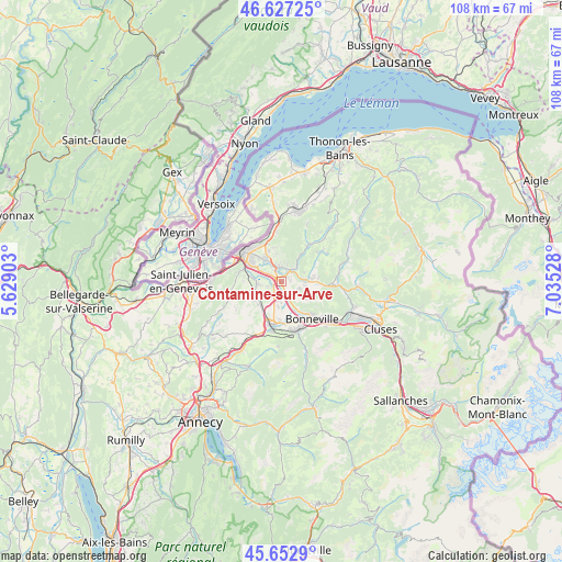
Contamine-sur-Arve GPS coordinates[2]
46° 8' 32.028" North, 6° 19' 55.74" East
| Map corner | latitude | longitude |
|---|---|---|
| Upper-left | 46.62725°, | 5.62903° |
| Center: | 46.14223°, | 6.33215° |
| Lower-right: | 45.6529°, | 7.03528° |
| Map W x H: | 108.3×108.3 km | = 67.3×67.3mi |
| max Lat: | 51.07786° ⇑64.4% North |
| Contamine-sur-Arve: | 46.14223° |
| min Lat: | ⇓35.6% South 41.3874° |
| min Long | Contamine-sur-A | max Long |
| -5.08615° | 6.33215° | 9.52242° |
| W 90.5%⇐ | ⇒9.5% E |
Elevation
Elevation of Contamine-sur-Arve is 526 m = 1726 ft, and this is 332.3 m = 1090 ft above average elevation for this country.
| Max E: |
2333 m = 7654 ft | 6.4% |
| Contamine-sur-Arve | 526 m 1726 ft | |
| Avg. | 193.7 m = 635 ft | |
Min E: |
-1 m = -3 ft | 93.6% |
See also: France elevation on elevation.city.
Geographical zone
Contamine-sur-Arve is located in North temperate zone (between Tropic of Cancer and the Arctic Circle). Distance of this North polar circle is 2270.6 km =1410.9 mi to North.| Distance of | km | miles | from Contamine-sur-Arve |
|---|---|---|---|
| North Pole | 4876.5 | 3030.1 | to North |
| Arctic Circle | 2270.6 | 1410.9 | to North |
| Tropic Cancer | 2524.6 | 1568.7 | to South |
| Equator | 5130.5 | 3187.9 | to South |


Nearby cities:
15 places around Contamine-sur-Arve: (largest is in red/bold)
• Arenthon
3.9 km =2.4 mi,  178°
178°
• Arthaz-Pont-Notre-Dame
5.4 km =3.4 mi,  290°
290°
• Bonne
3.4 km =2.1 mi,  349°
349°
• Cornier
6 km =3.7 mi,  205°
205°
• Cranves-Sales
5.7 km =3.5 mi,  333°
333°
• Fillinges
2.1 km =1.3 mi,  22°
22°
• Lucinges
5.7 km =3.5 mi, 346°
• Marcellaz
1.9 km =1.2 mi,  74°
74°
• Nangy
2.4 km =1.5 mi,  304°
304°
• Peillonnex
3.8 km =2.4 mi,  113°
113°
• Pers-Jussy
6.3 km =3.9 mi,  230°
230°
• Reignier-Ésery
5.1 km =3.2 mi,  258°
258°
• Saint-Jean-de-Tholome
5.8 km =3.6 mi,  124°
124°
• Scientrier
3 km =1.9 mi,  190°
190°
• Viuz-en-Sallaz
5.9 km =3.7 mi,  85°
85°
Sources, notices
• [Note1] Compared only with cities in France existing in our database
• [Src1] Map data: © OpenStreetMap contributors (CC-BY-SA)
• [Src2] Other city data from geonames.org with taken over terms of usage.
• [Src3] Geographical zone / Annual Mean Temperature by Robert A. Rohde @ Wikipedia
