Montagny geodata
Montagny (Auvergne-Rhône-Alpes) is a populated place; located in France in Europe/Paris (GMT+2) time zone. With population of 2,458 people, there are 3947 cities with bigger population in this country. Compared to other cities in France, 72.1% of cities are located further ↑North; 74.3% of cities are located further ←West and 72.8% of cities have lower elevation than Montagny. Note1
Administrative division(s):
- Level 1: Auvergne-Rhône-Alpes
- Level 2: Département du Rhône
- Level 3: Arrondissement de Lyon
- Level 4: Montagny


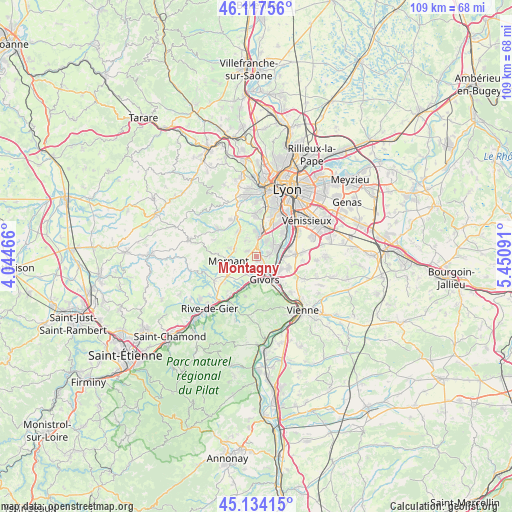
Montagny GPS coordinates[2]
45° 37' 40.836" North, 4° 44' 52.008" East
| Map corner | latitude | longitude |
|---|---|---|
| Upper-left | 46.11756°, | 4.04466° |
| Center: | 45.62801°, | 4.74778° |
| Lower-right: | 45.13415°, | 5.45091° |
| Map W x H: | 109.3×109.3 km | = 67.9×67.9mi |
| max Lat: | 51.07786° ⇑72.1% North |
| Montagny: | 45.62801° |
| min Lat: | ⇓27.9% South 41.3874° |
| min Long | Montagny | max Long |
| -5.08615° | 4.74778° | 9.52242° |
| W 74.3%⇐ | ⇒25.7% E |
Elevation
Elevation of Montagny is 235 m = 771 ft, and this is 41.3 m = 135 ft above average elevation for this country.
| Max E: |
2333 m = 7654 ft | 27.2% |
| Montagny | 235 m 771 ft | |
| Avg. | 193.7 m = 635 ft | |
Min E: |
-1 m = -3 ft | 72.8% |
See also: France elevation on elevation.city.
Geographical zone
Montagny is located in North temperate zone (between Tropic of Cancer and the Arctic Circle). Distance of this North polar circle is 2327.8 km =1446.4 mi to North.| Distance of | km | miles | from Montagny |
|---|---|---|---|
| North Pole | 4933.7 | 3065.7 | to North |
| Arctic Circle | 2327.8 | 1446.4 | to North |
| Tropic Cancer | 2467.4 | 1533.2 | to South |
| Equator | 5073.4 | 3152.5 | to South |


Nearby cities:
15 places around Montagny: (largest is in red/bold)
• Brignais
5.1 km =3.2 mi,  5°
5°
• Charly
4.3 km =2.7 mi,  57°
57°
• Chassagny
2.7 km =1.7 mi,  207°
207°
• Givors
4.5 km =2.8 mi,  158°
158°
• Grigny
3.9 km =2.4 mi,  123°
123°
• Millery
2.7 km =1.7 mi,  79°
79°
• Mornant
6 km =3.7 mi,  260°
260°
• Orliénas
4.1 km =2.5 mi,  326°
326°
• Saint-Andéol-le-Château
6.2 km =3.9 mi,  221°
221°
• Soucieu-en-Jarrest
6.5 km =4 mi, 328°
• Sérézin-du-Rhône
5.9 km =3.7 mi,  89°
89°
• Taluyers
2.4 km =1.5 mi,  303°
303°
• Ternay
5.7 km =3.5 mi, 120°
• Vernaison
5.4 km =3.4 mi,  66°
66°
• Vourles
4 km =2.5 mi,  30°
30°
Sources, notices
• [Note1] Compared only with cities in France existing in our database
• [Src1] Map data: © OpenStreetMap contributors (CC-BY-SA)
• [Src2] Other city data from geonames.org with taken over terms of usage.
• [Src3] Geographical zone / Annual Mean Temperature by Robert A. Rohde @ Wikipedia
